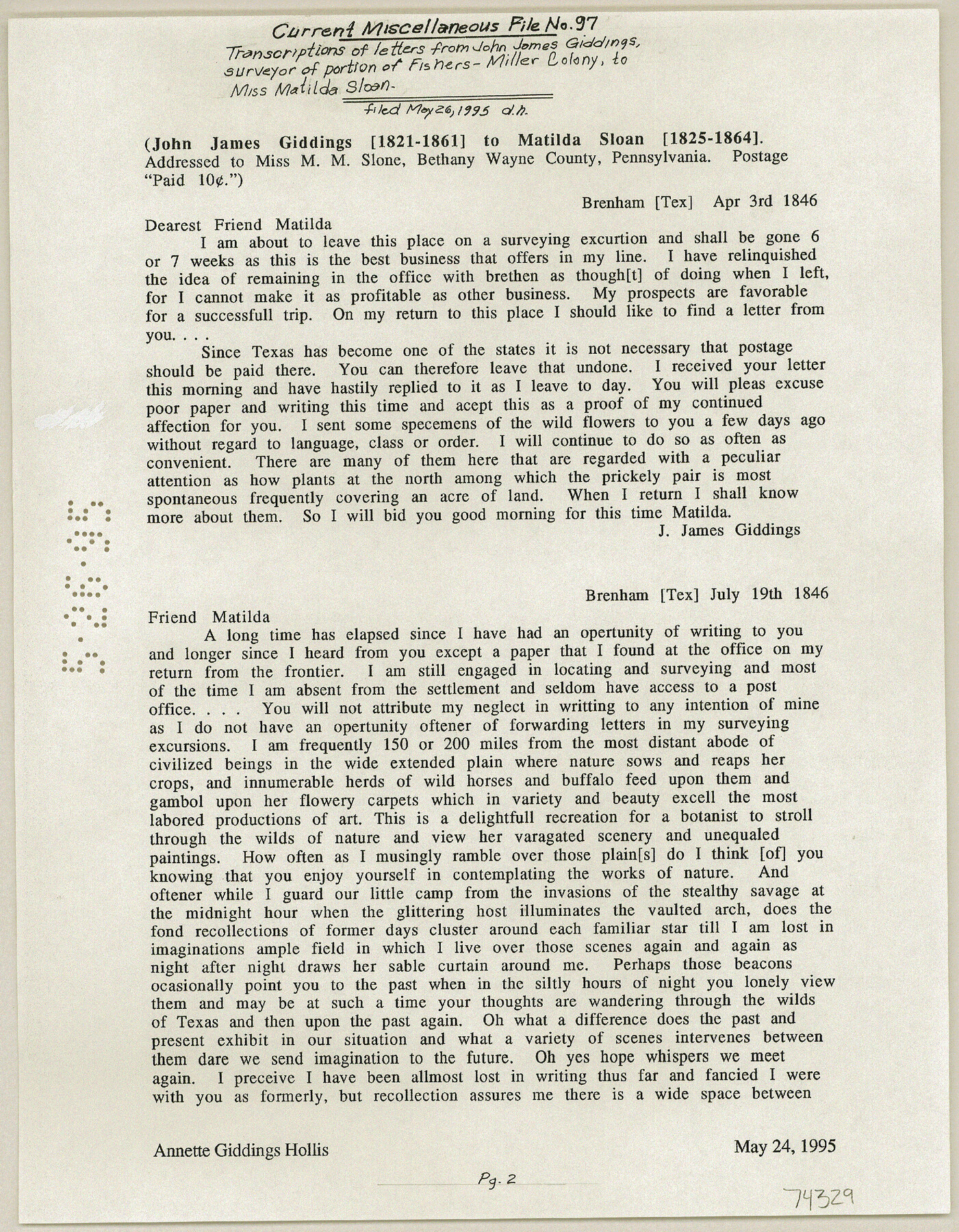
Current Miscellaneous File 97
Transcriptions of letters from John James Giddings (1821-1861) to Matilda Sloan (1825-1864). Mr. Giddings surveyed portion of Fisher-Miller Colony in 1847.
-
Map/Doc
74329
-
Collection
General Map Collection
-
Object Dates
1847/12/20 (Creation Date)
1995/5/30 (File Date)
-
Subjects
Colony
-
Height x Width
11.3 x 8.8 inches
28.7 x 22.4 cm
-
Medium
multi-page, multi-format
Part of: General Map Collection
Gillespie County Sketch File 12

Print $4.00
- Digital $50.00
Gillespie County Sketch File 12
1877
Size 9.6 x 6.3 inches
Map/Doc 24151
Van Zandt County Working Sketch 19

Print $20.00
- Digital $50.00
Van Zandt County Working Sketch 19
Size 43.3 x 32.8 inches
Map/Doc 72269
Crockett County Sketch File 43

Print $20.00
- Digital $50.00
Crockett County Sketch File 43
1880
Size 17.9 x 23.8 inches
Map/Doc 11223
Hardeman County Rolled Sketch 19

Print $52.00
- Digital $50.00
Hardeman County Rolled Sketch 19
1927
Size 30.9 x 31.5 inches
Map/Doc 9109
Sterling County Sketch File 7

Print $25.00
- Digital $50.00
Sterling County Sketch File 7
1926
Size 11.7 x 12.1 inches
Map/Doc 37121
Archer County Working Sketch 10a

Print $20.00
- Digital $50.00
Archer County Working Sketch 10a
1924
Size 25.9 x 40.6 inches
Map/Doc 67150
Van Zandt County Sketch File 9

Print $18.00
- Digital $50.00
Van Zandt County Sketch File 9
1859
Size 12.9 x 8.4 inches
Map/Doc 39384
Marion County Sketch File 19

Print $20.00
- Digital $50.00
Marion County Sketch File 19
2001
Size 11.2 x 8.8 inches
Map/Doc 30616
Live Oak County Working Sketch 1

Print $20.00
- Digital $50.00
Live Oak County Working Sketch 1
Size 20.4 x 29.1 inches
Map/Doc 70586
Matagorda County Rolled Sketch 37A

Print $40.00
- Digital $50.00
Matagorda County Rolled Sketch 37A
Size 48.7 x 41.1 inches
Map/Doc 10195
Flight Mission No. CLL-3N, Frame 33, Willacy County

Print $20.00
- Digital $50.00
Flight Mission No. CLL-3N, Frame 33, Willacy County
1954
Size 18.6 x 22.3 inches
Map/Doc 87090
Comal County Sketch File 21

Print $21.00
- Digital $50.00
Comal County Sketch File 21
1950
Size 9.1 x 11.4 inches
Map/Doc 19041
You may also like
[Liberty County, Texas]
![2058, [Liberty County, Texas], General Map Collection](https://historictexasmaps.com/wmedia_w700/maps/2058-1.tif.jpg)
Print $20.00
- Digital $50.00
[Liberty County, Texas]
1890
Size 23.7 x 18.3 inches
Map/Doc 2058
Flight Mission No. CLL-1N, Frame 39, Willacy County

Print $20.00
- Digital $50.00
Flight Mission No. CLL-1N, Frame 39, Willacy County
1954
Size 18.4 x 22.0 inches
Map/Doc 87020

Caldwell County Working Sketch 8

Print $20.00
- Digital $50.00
Caldwell County Working Sketch 8
1964
Size 29.1 x 22.8 inches
Map/Doc 67838
Tyler County Working Sketch 5

Print $20.00
- Digital $50.00
Tyler County Working Sketch 5
1928
Size 19.4 x 21.2 inches
Map/Doc 69475
Houston County Rolled Sketch 12

Print $20.00
- Digital $50.00
Houston County Rolled Sketch 12
Size 11.8 x 18.1 inches
Map/Doc 95396

Harrison County Boundary File 41 (10)

Print $10.00
- Digital $50.00
Harrison County Boundary File 41 (10)
Size 7.1 x 3.4 inches
Map/Doc 54418
Presidio County Working Sketch 101

Print $20.00
- Digital $50.00
Presidio County Working Sketch 101
1979
Size 37.6 x 31.0 inches
Map/Doc 71778
Hansford County Boundary File 4

Print $26.00
- Digital $50.00
Hansford County Boundary File 4
Size 14.1 x 8.7 inches
Map/Doc 54279
Eastland County Working Sketch 40

Print $20.00
- Digital $50.00
Eastland County Working Sketch 40
1970
Size 27.9 x 26.0 inches
Map/Doc 68821
New Hobbs, Lea County, New Mexico

Print $20.00
- Digital $50.00
New Hobbs, Lea County, New Mexico
Size 15.7 x 20.1 inches
Map/Doc 92424