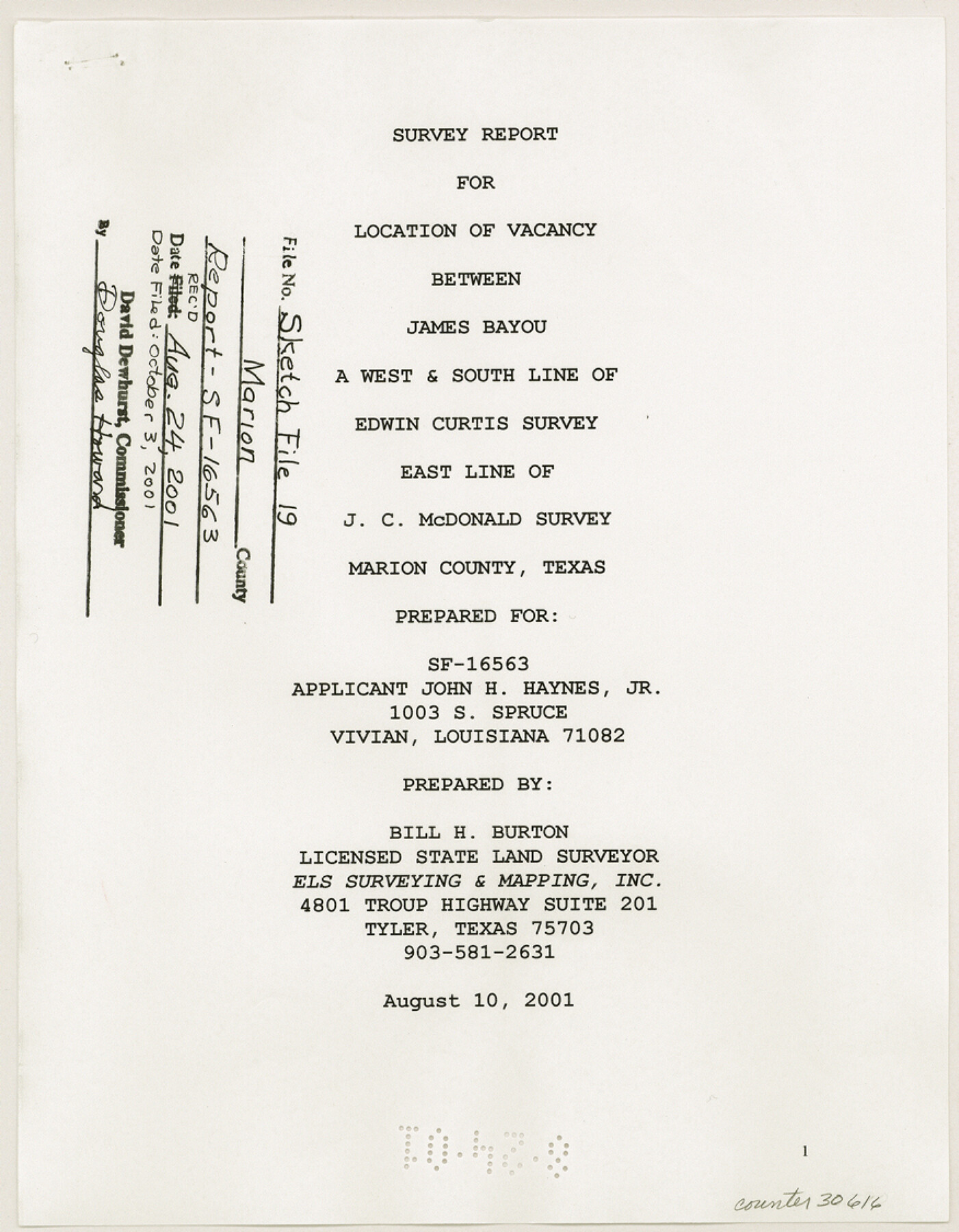
Marion County Sketch File 19
[Survey report for location of vacancy between James Bayou a west and south line of Edwin Curtis survey east line of J. C. McDonald survey]
-
Map/Doc
30616
-
Collection
General Map Collection
-
Object Dates
8/10/2001 (Creation Date)
10/3/2001 (File Date)
-
People and Organizations
Bill H. Burton (Surveyor/Engineer)
-
Counties
Marion
-
Subjects
Surveying Sketch File
-
Height x Width
11.2 x 8.8 inches
28.5 x 22.4 cm
-
Medium
paper, print
-
Comments
See Marion County Rolled Sketches 9a (76419) and 9b (76420).
-
Features
James Bayou
Related maps
Marion County Rolled Sketch 9A

Print $20.00
- Digital $50.00
Marion County Rolled Sketch 9A
2001
Size 22.9 x 22.9 inches
Map/Doc 76419
Marion County Rolled Sketch 9B

Print $20.00
- Digital $50.00
Marion County Rolled Sketch 9B
2001
Size 22.5 x 22.4 inches
Map/Doc 76420
Part of: General Map Collection
Hopkins County Sketch File 17

Print $6.00
- Digital $50.00
Hopkins County Sketch File 17
1870
Size 7.8 x 8.0 inches
Map/Doc 26720
Hood County Rolled Sketch 5

Print $20.00
- Digital $50.00
Hood County Rolled Sketch 5
1980
Size 29.9 x 32.2 inches
Map/Doc 6221
Map of the country adjacent to the left bank of the Rio Grande below Matamoros

Print $20.00
- Digital $50.00
Map of the country adjacent to the left bank of the Rio Grande below Matamoros
1847
Size 18.3 x 28.2 inches
Map/Doc 72871
[Sketch for Mineral Application 36425 - Jefferson County, Ley C. Moore]
![65615, [Sketch for Mineral Application 36425 - Jefferson County, Ley C. Moore], General Map Collection](https://historictexasmaps.com/wmedia_w700/maps/65615.tif.jpg)
Print $40.00
- Digital $50.00
[Sketch for Mineral Application 36425 - Jefferson County, Ley C. Moore]
1942
Size 35.0 x 49.3 inches
Map/Doc 65615
Map of Jones County West of the Clearfork of the Brazos River Young - East of it Milam - Land District

Print $20.00
- Digital $50.00
Map of Jones County West of the Clearfork of the Brazos River Young - East of it Milam - Land District
1859
Size 22.0 x 26.5 inches
Map/Doc 3741
Northwest Part of Webb County

Print $40.00
- Digital $50.00
Northwest Part of Webb County
1984
Size 42.6 x 52.2 inches
Map/Doc 73319
Flight Mission No. DCL-6C, Frame 112, Kenedy County

Print $20.00
- Digital $50.00
Flight Mission No. DCL-6C, Frame 112, Kenedy County
1943
Size 15.4 x 15.5 inches
Map/Doc 85942

Zavala County Rolled Sketch 20

Print $20.00
- Digital $50.00
Zavala County Rolled Sketch 20
Size 33.9 x 26.3 inches
Map/Doc 8323
Foard County Sketch File 17

Print $12.00
- Digital $50.00
Foard County Sketch File 17
1882
Size 14.2 x 8.8 inches
Map/Doc 22828
Laguna Madre, T-9212

Print $20.00
- Digital $50.00
Laguna Madre, T-9212
Size 33.1 x 31.4 inches
Map/Doc 73603
St. Louis Southwestern Railway of Texas

Print $40.00
- Digital $50.00
St. Louis Southwestern Railway of Texas
1905
Size 15.3 x 87.2 inches
Map/Doc 64445
You may also like
Surveys on the Coleto Creek, Goliad County

Print $20.00
- Digital $50.00
Surveys on the Coleto Creek, Goliad County
1841
Size 13.8 x 14.9 inches
Map/Doc 10
Palo Pinto County Rolled Sketch 5

Print $40.00
- Digital $50.00
Palo Pinto County Rolled Sketch 5
Size 54.4 x 36.0 inches
Map/Doc 76021

Flight Mission No. CRC-4R, Frame 176, Chambers County

Print $20.00
- Digital $50.00
Flight Mission No. CRC-4R, Frame 176, Chambers County
1956
Size 18.6 x 22.3 inches
Map/Doc 84927
Dimmit County Working Sketch 11

Print $20.00
- Digital $50.00
Dimmit County Working Sketch 11
1935
Size 28.7 x 31.7 inches
Map/Doc 68672
General Highway Map, Coleman County, Texas

Print $20.00
General Highway Map, Coleman County, Texas
1940
Size 18.4 x 25.2 inches
Map/Doc 79050
Galveston County NRC Article 33.136 Sketch 55A

Print $28.00
- Digital $50.00
Galveston County NRC Article 33.136 Sketch 55A
2009
Size 24.0 x 36.0 inches
Map/Doc 94616
Harris County Working Sketch 87

Print $20.00
- Digital $50.00
Harris County Working Sketch 87
1972
Size 34.1 x 31.0 inches
Map/Doc 65979
Correct Map of Texas and Louisiana

Print $40.00
- Digital $50.00
Correct Map of Texas and Louisiana
1917
Size 41.6 x 53.6 inches
Map/Doc 2142
Reagan County Working Sketch 21

Print $20.00
- Digital $50.00
Reagan County Working Sketch 21
1955
Size 23.4 x 19.9 inches
Map/Doc 71863
Capitol Land Reservation

Print $40.00
- Digital $50.00
Capitol Land Reservation
1882
Size 51.4 x 18.0 inches
Map/Doc 76175
Pecos County Sketch File 44

Print $8.00
- Digital $50.00
Pecos County Sketch File 44
Size 13.0 x 10.4 inches
Map/Doc 33743