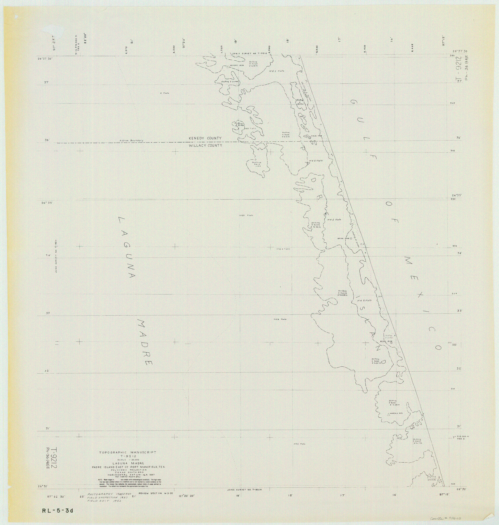
Laguna Madre, T-9212
Topographic Manuscript Laguna Madre, Padre Island East of Port Mansfield
-
Map/Doc
73603
-
Collection
General Map Collection
-
Counties
Kenedy Willacy
-
Subjects
Nautical Charts
-
Height x Width
33.1 x 31.4 inches
84.1 x 79.8 cm
Part of: General Map Collection
Map of Jack County

Print $20.00
- Digital $50.00
Map of Jack County
1896
Size 43.6 x 38.9 inches
Map/Doc 66877
Lines of Equal Magnetic Declination and of Equal Annual Change in the United States for 1930

Print $20.00
- Digital $50.00
Lines of Equal Magnetic Declination and of Equal Annual Change in the United States for 1930
1930
Size 23.5 x 29.7 inches
Map/Doc 69652
Presidio County Working Sketch 84

Print $20.00
- Digital $50.00
Presidio County Working Sketch 84
1970
Size 20.7 x 17.8 inches
Map/Doc 71761
United States of America, compiled from the latest & best authorities by John Melish, 1820

Print $20.00
- Digital $50.00
United States of America, compiled from the latest & best authorities by John Melish, 1820
1820
Size 16.7 x 20.2 inches
Map/Doc 89220
Frio County Sketch File 1

Print $8.00
- Digital $50.00
Frio County Sketch File 1
1848
Size 8.6 x 7.7 inches
Map/Doc 23101
Grayson County Rolled Sketch 3

Print $20.00
- Digital $50.00
Grayson County Rolled Sketch 3
1952
Size 33.7 x 46.1 inches
Map/Doc 9666
Camp County Working Sketch 3

Print $20.00
- Digital $50.00
Camp County Working Sketch 3
1982
Size 32.1 x 24.4 inches
Map/Doc 67879
Bandera County Working Sketch 9

Print $20.00
- Digital $50.00
Bandera County Working Sketch 9
1920
Size 15.2 x 17.1 inches
Map/Doc 67602
El Paso County Sketch File 35 (3)

Print $40.00
- Digital $50.00
El Paso County Sketch File 35 (3)
1886
Size 12.8 x 8.3 inches
Map/Doc 22179
Bexar County Sketch File 29

Print $40.00
- Digital $50.00
Bexar County Sketch File 29
Size 11.3 x 36.7 inches
Map/Doc 10919
Travis County State Real Property Sketch 6

Print $40.00
- Digital $50.00
Travis County State Real Property Sketch 6
1987
Size 30.2 x 41.4 inches
Map/Doc 61697
Map of a part of Laguna Madre showing subdivision for mineral development

Print $20.00
- Digital $50.00
Map of a part of Laguna Madre showing subdivision for mineral development
1950
Size 40.7 x 26.9 inches
Map/Doc 2917
You may also like
Hockley County Boundary File 4

Print $76.00
- Digital $50.00
Hockley County Boundary File 4
Size 14.3 x 8.7 inches
Map/Doc 54810
Parker County Working Sketch 23

Print $20.00
- Digital $50.00
Parker County Working Sketch 23
2007
Map/Doc 87924
Correct Map of Lamb County, Texas

Print $40.00
- Digital $50.00
Correct Map of Lamb County, Texas
1914
Size 47.1 x 57.1 inches
Map/Doc 89954
Fannin County Sketch File 19

Print $4.00
- Digital $50.00
Fannin County Sketch File 19
1878
Size 8.3 x 10.0 inches
Map/Doc 22473
Montague County Working Sketch 17

Print $20.00
- Digital $50.00
Montague County Working Sketch 17
1947
Size 22.1 x 30.0 inches
Map/Doc 71083
[Surveys in Austin's Colony on both sides of the Navidad River]
![217, [Surveys in Austin's Colony on both sides of the Navidad River], General Map Collection](https://historictexasmaps.com/wmedia_w700/maps/217.tif.jpg)
Print $20.00
- Digital $50.00
[Surveys in Austin's Colony on both sides of the Navidad River]
1831
Size 18.8 x 12.7 inches
Map/Doc 217
Section IX, Galveston Harbor and Bar

Print $20.00
- Digital $50.00
Section IX, Galveston Harbor and Bar
1850
Size 30.0 x 45.7 inches
Map/Doc 69855
Cass County Sketch File 4

Print $6.00
- Digital $50.00
Cass County Sketch File 4
1853
Size 8.2 x 11.2 inches
Map/Doc 17398
Williamson County Sketch File 4

Print $26.00
- Digital $50.00
Williamson County Sketch File 4
1849
Size 15.9 x 10.4 inches
Map/Doc 40304
Stephens County Sketch File 10a

Print $8.00
- Digital $50.00
Stephens County Sketch File 10a
1884
Size 12.7 x 8.5 inches
Map/Doc 37044
Webb County Working Sketch 67

Print $40.00
- Digital $50.00
Webb County Working Sketch 67
1966
Size 60.9 x 43.7 inches
Map/Doc 72434
Galveston County NRC Article 33.136 Sketch 6

Print $20.00
- Digital $50.00
Galveston County NRC Article 33.136 Sketch 6
2001
Size 23.1 x 33.9 inches
Map/Doc 61588