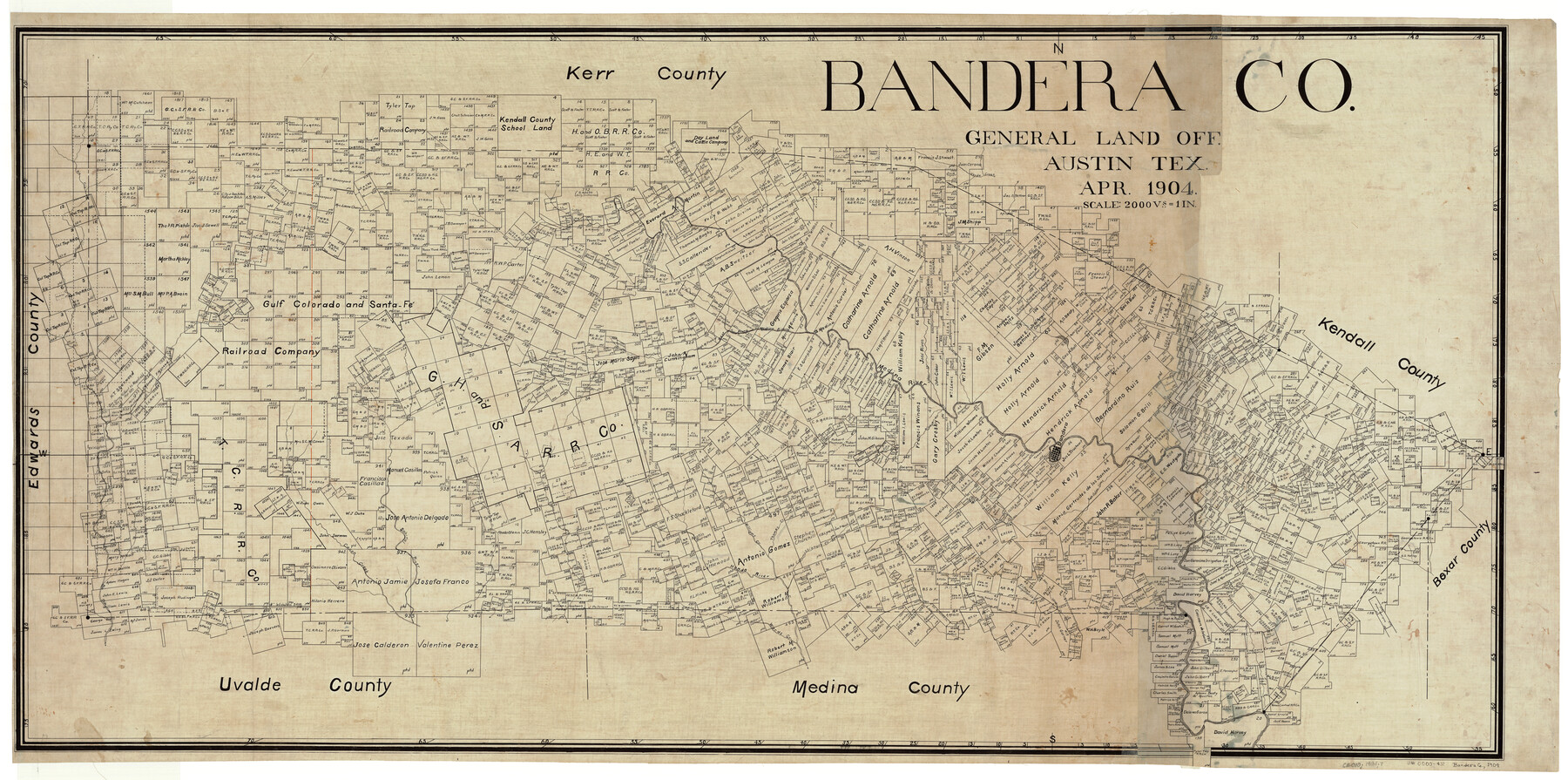
Bandera Co.
-
Map/Doc
4880
-
Collection
General Map Collection
-
Object Dates
1904 (Creation Date)
-
People and Organizations
Texas General Land Office (Publisher)
-
Counties
Bandera
-
Subjects
County
-
Height x Width
31.1 x 62.5 inches
79.0 x 158.8 cm
Part of: General Map Collection
Clay County Sketch File 29

Print $16.00
- Digital $50.00
Clay County Sketch File 29
Size 11.3 x 8.7 inches
Map/Doc 18448
Reagan County Working Sketch 19

Print $20.00
- Digital $50.00
Reagan County Working Sketch 19
1954
Size 24.3 x 42.9 inches
Map/Doc 71861
Potter County Boundary File 3a

Print $4.00
- Digital $50.00
Potter County Boundary File 3a
Size 11.2 x 8.7 inches
Map/Doc 57977
Map of Hidalgo County

Print $20.00
- Digital $50.00
Map of Hidalgo County
1880
Size 45.3 x 25.1 inches
Map/Doc 3667
Sutton County Working Sketch 34

Print $20.00
- Digital $50.00
Sutton County Working Sketch 34
1939
Size 24.3 x 30.6 inches
Map/Doc 62377
Northeast Part of Webb County

Print $40.00
- Digital $50.00
Northeast Part of Webb County
1986
Size 38.0 x 49.2 inches
Map/Doc 73318

Jackson County Sketch File 23

Print $6.00
- Digital $50.00
Jackson County Sketch File 23
1949
Size 11.2 x 8.6 inches
Map/Doc 27703
Flight Mission No. DQO-1K, Frame 152, Galveston County

Print $20.00
- Digital $50.00
Flight Mission No. DQO-1K, Frame 152, Galveston County
1952
Size 18.9 x 22.5 inches
Map/Doc 85005
Archer County Boundary File 5

Print $3.00
- Digital $50.00
Archer County Boundary File 5
Size 16.9 x 6.8 inches
Map/Doc 50112

Travis County Sketch File 61

Print $8.00
- Digital $50.00
Travis County Sketch File 61
1948
Size 14.4 x 8.8 inches
Map/Doc 38427
You may also like
Jack County Working Sketch 12

Print $20.00
- Digital $50.00
Jack County Working Sketch 12
1959
Size 18.0 x 22.4 inches
Map/Doc 66438
Milam County Boundary File 5a

Print $12.00
- Digital $50.00
Milam County Boundary File 5a
Size 14.1 x 8.5 inches
Map/Doc 57233
Flight Mission No. CLL-1N, Frame 34, Willacy County

Print $20.00
- Digital $50.00
Flight Mission No. CLL-1N, Frame 34, Willacy County
1954
Size 18.4 x 22.2 inches
Map/Doc 87015
San Patricio County Rolled Sketch 32

Print $20.00
- Digital $50.00
San Patricio County Rolled Sketch 32
1948
Size 38.8 x 25.0 inches
Map/Doc 7583
Map of the Roman Empire to illustrate Ancient History, engraved for Olney's school atlas

Print $20.00
- Digital $50.00
Map of the Roman Empire to illustrate Ancient History, engraved for Olney's school atlas
1845
Size 12.1 x 19.0 inches
Map/Doc 93550
Frio County Working Sketch Graphic Index

Print $20.00
- Digital $50.00
Frio County Working Sketch Graphic Index
1944
Size 43.0 x 41.4 inches
Map/Doc 76549
Terrell County

Print $20.00
- Digital $50.00
Terrell County
1905
Size 40.5 x 32.3 inches
Map/Doc 4075
Clay County Sketch File 37

Print $8.00
- Digital $50.00
Clay County Sketch File 37
1935
Size 11.6 x 7.2 inches
Map/Doc 18465
Map of the Western Part of Travis County, Texas

Print $20.00
- Digital $50.00
Map of the Western Part of Travis County, Texas
1919
Size 36.2 x 29.9 inches
Map/Doc 10754
Cass County Rolled Sketch BRR

Print $40.00
- Digital $50.00
Cass County Rolled Sketch BRR
1936
Size 67.3 x 28.0 inches
Map/Doc 8581
Howard County Sketch File 10

Print $20.00
- Digital $50.00
Howard County Sketch File 10
Size 22.5 x 22.0 inches
Map/Doc 11798
Navigation Maps of Gulf Intracoastal Waterway, Port Arthur to Brownsville, Texas

Print $4.00
- Digital $50.00
Navigation Maps of Gulf Intracoastal Waterway, Port Arthur to Brownsville, Texas
1951
Size 16.6 x 21.5 inches
Map/Doc 65430