Potter County Boundary File 3a
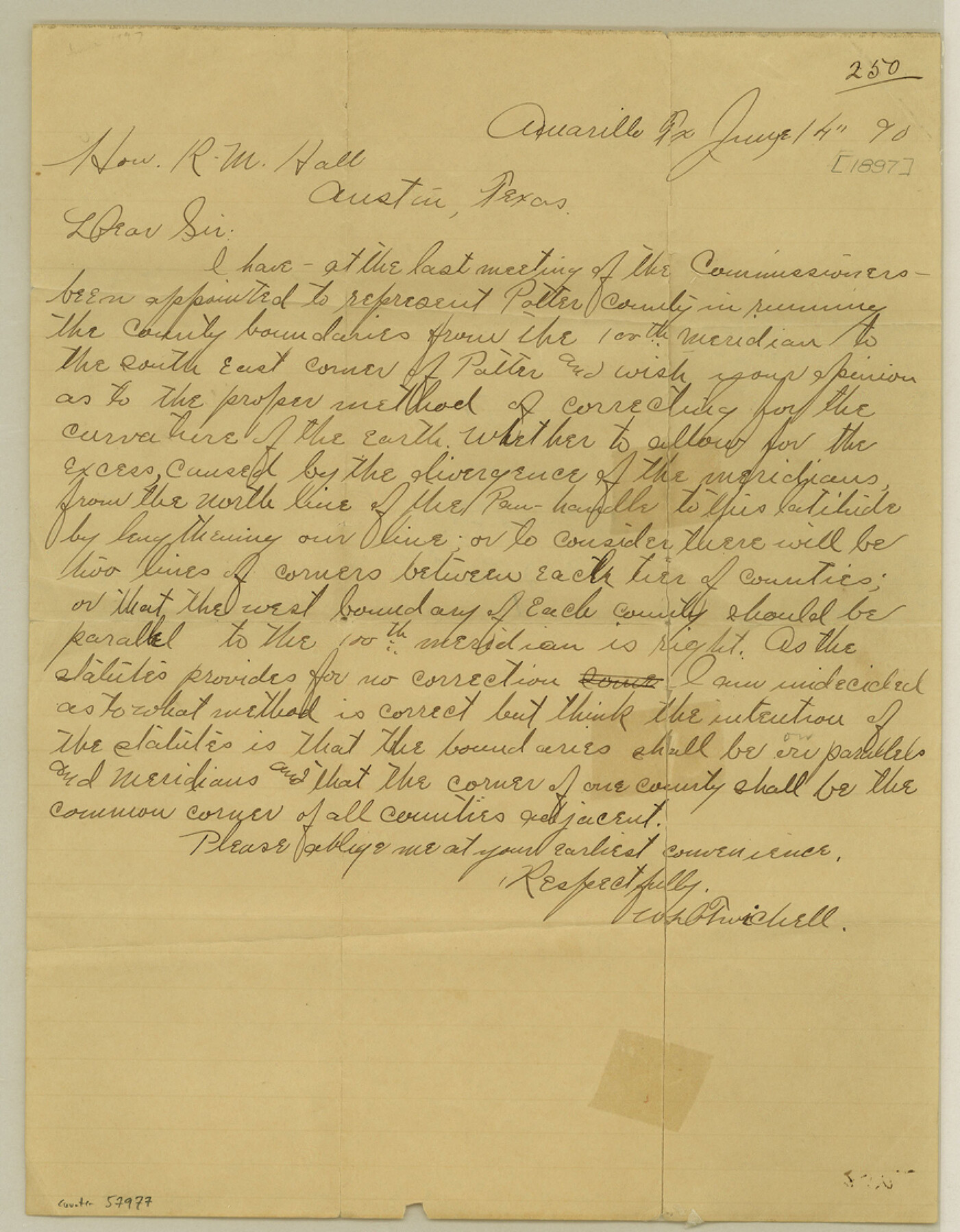
[Letter from W. D. Twichell stating he was appointed to represent Potter County in running the county boundaries from the 100th meridian to the south east corner of Potter]
-
Map/Doc
57977
-
Collection
General Map Collection
-
Counties
Potter
-
Subjects
County Boundaries
-
Height x Width
11.2 x 8.7 inches
28.5 x 22.1 cm
Part of: General Map Collection
Cherokee County Working Sketch Graphic Index

Print $40.00
- Digital $50.00
Cherokee County Working Sketch Graphic Index
1933
Size 56.7 x 40.0 inches
Map/Doc 76492
Freestone County Working Sketch 31

Print $20.00
- Digital $50.00
Freestone County Working Sketch 31
1995
Size 42.8 x 33.9 inches
Map/Doc 78205
Flight Mission No. BRA-8M, Frame 73, Jefferson County

Print $20.00
- Digital $50.00
Flight Mission No. BRA-8M, Frame 73, Jefferson County
1953
Size 18.7 x 22.3 inches
Map/Doc 85593
Jasper County Sketch File 19

Print $6.00
- Digital $50.00
Jasper County Sketch File 19
1890
Size 14.2 x 8.8 inches
Map/Doc 27815
Flight Mission No. BQR-22K, Frame 43, Brazoria County

Print $20.00
- Digital $50.00
Flight Mission No. BQR-22K, Frame 43, Brazoria County
1953
Size 18.6 x 22.3 inches
Map/Doc 84127
Subdivision Plat of Blue Ridge State Farm Showing 18 Tracts

Print $20.00
- Digital $50.00
Subdivision Plat of Blue Ridge State Farm Showing 18 Tracts
Size 27.0 x 27.4 inches
Map/Doc 62978
Flight Mission No. CRC-4R, Frame 95, Chambers County

Print $20.00
- Digital $50.00
Flight Mission No. CRC-4R, Frame 95, Chambers County
1956
Size 18.6 x 22.3 inches
Map/Doc 84892
Sutton County Sketch File 2

Print $4.00
- Digital $50.00
Sutton County Sketch File 2
1898
Size 6.1 x 9.7 inches
Map/Doc 37351
Uvalde County Working Sketch 23

Print $20.00
- Digital $50.00
Uvalde County Working Sketch 23
1952
Size 32.0 x 26.6 inches
Map/Doc 72093
El Paso County Rolled Sketch 26

Print $20.00
- Digital $50.00
El Paso County Rolled Sketch 26
Size 44.5 x 34.1 inches
Map/Doc 8857
Panola County

Print $20.00
- Digital $50.00
Panola County
1947
Size 40.8 x 40.3 inches
Map/Doc 66969
Flight Mission No. DCL-7C, Frame 113, Kenedy County

Print $20.00
- Digital $50.00
Flight Mission No. DCL-7C, Frame 113, Kenedy County
1943
Size 18.5 x 22.2 inches
Map/Doc 86078
You may also like
Geological Highway Map of Texas

Geological Highway Map of Texas
1973
Size 27.9 x 36.5 inches
Map/Doc 77523
[Surveys in Henderson County, Nacogdoches/Houston District]
![69735, [Surveys in Henderson County, Nacogdoches/Houston District], General Map Collection](https://historictexasmaps.com/wmedia_w700/maps/69735.tif.jpg)
Print $2.00
- Digital $50.00
[Surveys in Henderson County, Nacogdoches/Houston District]
Size 11.0 x 7.9 inches
Map/Doc 69735
Lamb County Sketch File 1 and 1a

Print $30.00
- Digital $50.00
Lamb County Sketch File 1 and 1a
Size 8.7 x 7.6 inches
Map/Doc 29337
Montague County Working Sketch 13

Print $20.00
- Digital $50.00
Montague County Working Sketch 13
1939
Size 26.0 x 20.6 inches
Map/Doc 71079
Edwards County Working Sketch 102

Print $20.00
- Digital $50.00
Edwards County Working Sketch 102
1971
Size 35.0 x 25.5 inches
Map/Doc 68978
Texas-United States Boundary Line 1

Print $4.00
- Digital $50.00
Texas-United States Boundary Line 1
1843
Size 12.6 x 7.8 inches
Map/Doc 74974
A Traveler's Map of Spain and Portugal

A Traveler's Map of Spain and Portugal
Size 22.8 x 36.3 inches
Map/Doc 95938
Map of the International and Great Northern Railroad between Austin and San Antonio, Texas

Print $40.00
- Digital $50.00
Map of the International and Great Northern Railroad between Austin and San Antonio, Texas
1881
Size 43.2 x 96.0 inches
Map/Doc 64777
[Maps of surveys in Reeves & Culberson Cos]
![61141, [Maps of surveys in Reeves & Culberson Cos], General Map Collection](https://historictexasmaps.com/wmedia_w700/maps/61141.tif.jpg)
Print $20.00
- Digital $50.00
[Maps of surveys in Reeves & Culberson Cos]
1937
Size 30.7 x 24.9 inches
Map/Doc 61141
Flight Mission No. BRA-16M, Frame 116, Jefferson County

Print $20.00
- Digital $50.00
Flight Mission No. BRA-16M, Frame 116, Jefferson County
1953
Size 18.5 x 22.3 inches
Map/Doc 85726
[Surveys along San Cristoval Creek]
![300, [Surveys along San Cristoval Creek], General Map Collection](https://historictexasmaps.com/wmedia_w700/maps/300.tif.jpg)
Print $2.00
- Digital $50.00
[Surveys along San Cristoval Creek]
1842
Size 9.0 x 9.3 inches
Map/Doc 300
Republic Counties. January 1, 1845

Print $20.00
Republic Counties. January 1, 1845
2020
Size 24.5 x 21.7 inches
Map/Doc 96318