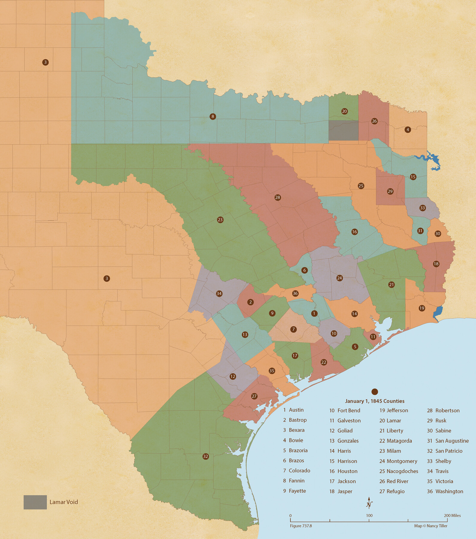
Republic Counties. January 1, 1845
Figure No. 737.8 from 'A Boundary Atlas of Texas, 1821-1845' by Jim Tiller
-
Map/Doc
96318
-
Collection
Nancy and Jim Tiller Digital Collection
-
Object Dates
2020/1/1 (Creation Date)
-
People and Organizations
Jim Tiller (Author)
Nancy Tiller (Cartographer)
Gang Gong (GIS Professional)
-
Subjects
Atlas Republic of Texas Texas Boundaries
-
Height x Width
24.5 x 21.7 inches
62.2 x 55.1 cm
-
Medium
digital image
-
Comments
To purchase a digital PDF copy of "A Boundary Atlas of Texas, 1821-1845" see 96437.
Part of: Nancy and Jim Tiller Digital Collection
The Republic County of Jackson. September 17, 1838

Print $20.00
The Republic County of Jackson. September 17, 1838
2020
Size 15.6 x 21.8 inches
Map/Doc 96185
The Republic County of Colorado. Spring 1842

Print $20.00
The Republic County of Colorado. Spring 1842
2020
Size 18.4 x 21.7 inches
Map/Doc 96126
The Mexican Municipality of San Augustine. Created March 6, 1834

Print $20.00
The Mexican Municipality of San Augustine. Created March 6, 1834
2020
Size 24.1 x 21.7 inches
Map/Doc 96032
Austin Empresario Colony. April 27, 1825

Print $20.00
Austin Empresario Colony. April 27, 1825
2020
Size 18.1 x 21.6 inches
Map/Doc 95979
From Citizens of Shelby and Red River Counties Living East of the Sabine River and Southwest of the Sulphur Fork of Red River for the Creation of a New County to be Called Green, March 11, 1837/April 1, 1837

Print $20.00
From Citizens of Shelby and Red River Counties Living East of the Sabine River and Southwest of the Sulphur Fork of Red River for the Creation of a New County to be Called Green, March 11, 1837/April 1, 1837
2020
Size 24.3 x 21.7 inches
Map/Doc 96373
The Judicial District/County of Lavaca. Abolished, Spring 1842

Print $20.00
The Judicial District/County of Lavaca. Abolished, Spring 1842
2020
Size 14.6 x 21.7 inches
Map/Doc 96332
The Chief Justice County of Colorado. Undated

Print $20.00
The Chief Justice County of Colorado. Undated
2020
Size 14.8 x 21.6 inches
Map/Doc 96044
The Republic County of Fannin. November 28. 1839

Print $20.00
The Republic County of Fannin. November 28. 1839
2020
Size 12.9 x 21.7 inches
Map/Doc 96129
The Republic County of Fort Bend. January 10, 1839

Print $20.00
The Republic County of Fort Bend. January 10, 1839
2020
Size 14.7 x 21.6 inches
Map/Doc 96138
The Republic County of Red River. Spring 1842

Print $20.00
The Republic County of Red River. Spring 1842
2020
Size 21.0 x 21.7 inches
Map/Doc 96254
The Republic County of Lamar. December 29, 1845

Print $20.00
The Republic County of Lamar. December 29, 1845
2020
Size 16.4 x 21.7 inches
Map/Doc 96207
Edwards Empresario Colony. April 15, 1825

Print $20.00
Edwards Empresario Colony. April 15, 1825
2020
Size 18.1 x 21.6 inches
Map/Doc 95993
You may also like
Coryell County Boundary File 3

Print $14.00
- Digital $50.00
Coryell County Boundary File 3
Size 13.2 x 8.2 inches
Map/Doc 51907
Bowie County Sketch File 1

Print $8.00
- Digital $50.00
Bowie County Sketch File 1
Size 8.6 x 10.0 inches
Map/Doc 14833
Smith County Working Sketch 4

Print $20.00
- Digital $50.00
Smith County Working Sketch 4
1913
Size 13.5 x 17.9 inches
Map/Doc 63889
Rusk County Sketch File 6

Print $4.00
Rusk County Sketch File 6
1848
Size 6.3 x 7.9 inches
Map/Doc 35499
Johnson County Sketch File 25

Print $50.00
- Digital $50.00
Johnson County Sketch File 25
Size 13.9 x 8.3 inches
Map/Doc 28459
[Surveys along Tehuacano and Grindstone Creek, drawings X and Y]
![299, [Surveys along Tehuacano and Grindstone Creek, drawings X and Y], General Map Collection](https://historictexasmaps.com/wmedia_w700/maps/299.tif.jpg)
Print $20.00
- Digital $50.00
[Surveys along Tehuacano and Grindstone Creek, drawings X and Y]
1846
Size 12.4 x 18.3 inches
Map/Doc 299
Jasper County Rolled Sketch 4

Print $20.00
- Digital $50.00
Jasper County Rolled Sketch 4
1947
Size 40.0 x 31.1 inches
Map/Doc 6351
Palo Pinto County Rolled Sketch 12

Print $20.00
- Digital $50.00
Palo Pinto County Rolled Sketch 12
1984
Size 32.2 x 28.9 inches
Map/Doc 7192
Scurry County Rolled Sketch 9

Print $20.00
- Digital $50.00
Scurry County Rolled Sketch 9
1963
Size 23.0 x 22.0 inches
Map/Doc 7769
[Copied from a chart of Galveston Bar and Harbor]
![72760, [Copied from a chart of Galveston Bar and Harbor], General Map Collection](https://historictexasmaps.com/wmedia_w700/maps/72760.tif.jpg)
Print $20.00
- Digital $50.00
[Copied from a chart of Galveston Bar and Harbor]
1846
Size 18.3 x 25.3 inches
Map/Doc 72760
Marion County Working Sketch 28

Print $20.00
- Digital $50.00
Marion County Working Sketch 28
1975
Size 24.0 x 33.5 inches
Map/Doc 70804
Kenedy County Aerial Photograph Index Sheet 9

Print $20.00
- Digital $50.00
Kenedy County Aerial Photograph Index Sheet 9
1943
Size 23.6 x 18.5 inches
Map/Doc 83717