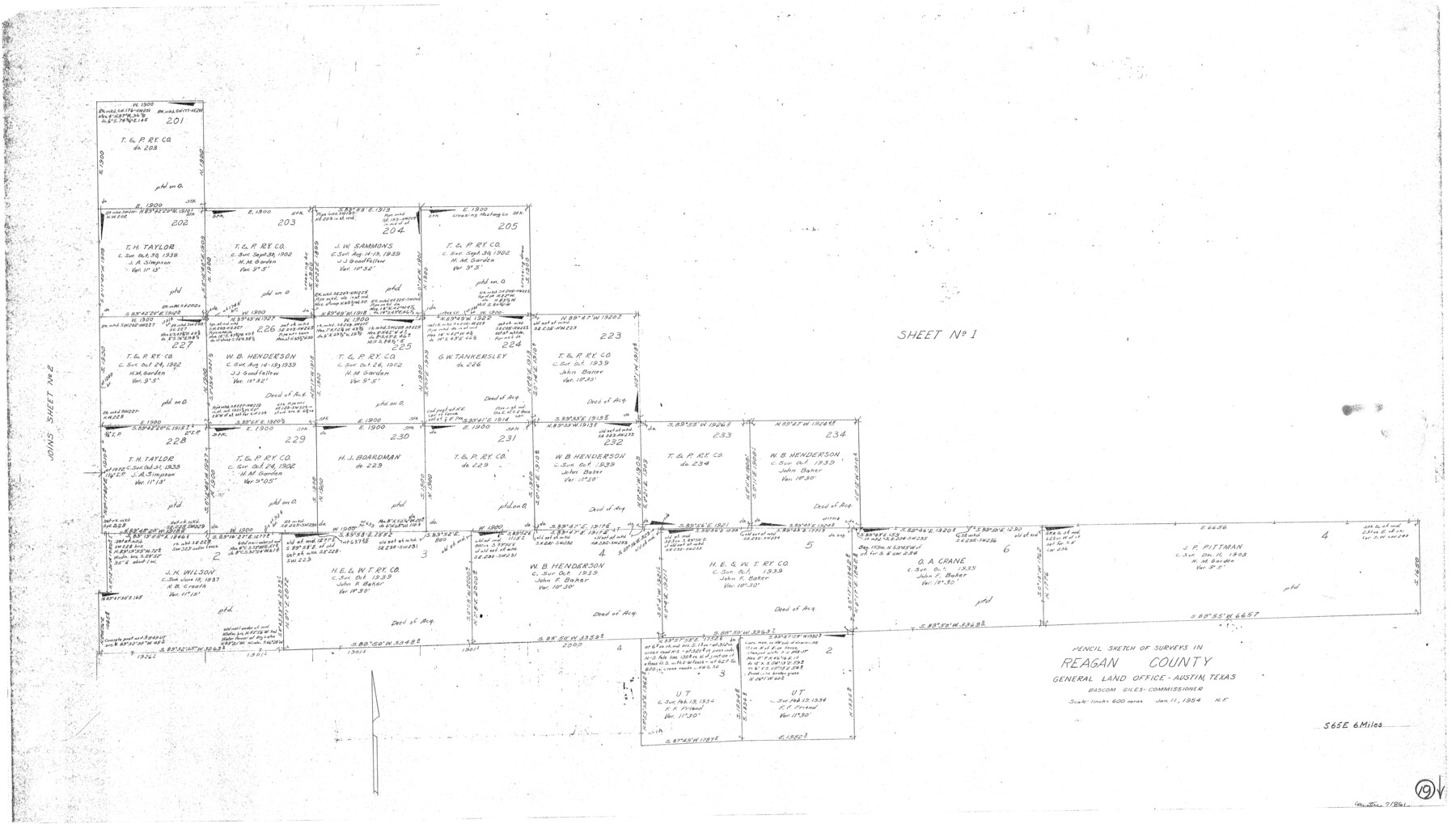
Reagan County Working Sketch 19
-
Map/Doc
71861
-
Collection
General Map Collection
-
Object Dates
1/11/1954 (Creation Date)
-
People and Organizations
Herman Forbes (Draftsman)
-
Counties
Reagan
-
Subjects
Surveying Working Sketch
-
Height x Width
24.3 x 42.9 inches
61.7 x 109.0 cm
-
Scale
1" = 600 varas
Part of: General Map Collection
Travis County Boundary File 28

Print $8.00
- Digital $50.00
Travis County Boundary File 28
Size 14.7 x 9.0 inches
Map/Doc 59464
[Galveston, Harrisburg & San Antonio through El Paso County]
![64008, [Galveston, Harrisburg & San Antonio through El Paso County], General Map Collection](https://historictexasmaps.com/wmedia_w700/maps/64008.tif.jpg)
Print $20.00
- Digital $50.00
[Galveston, Harrisburg & San Antonio through El Paso County]
1906
Size 13.7 x 33.8 inches
Map/Doc 64008
Leon County Working Sketch 59

Print $20.00
- Digital $50.00
Leon County Working Sketch 59
1998
Size 19.2 x 25.5 inches
Map/Doc 70459
Reagan County Sketch File 5

Print $12.00
- Digital $50.00
Reagan County Sketch File 5
1927
Size 11.2 x 8.7 inches
Map/Doc 34980
Zavala County Rolled Sketch 32

Print $20.00
- Digital $50.00
Zavala County Rolled Sketch 32
Size 22.5 x 38.2 inches
Map/Doc 8333
Hill County Sketch File 20

Print $22.00
- Digital $50.00
Hill County Sketch File 20
1854
Size 8.3 x 7.7 inches
Map/Doc 26490
[Surveys in Polk and Chambers Counties]
![355, [Surveys in Polk and Chambers Counties], General Map Collection](https://historictexasmaps.com/wmedia_w700/maps/355.tif.jpg)
Print $3.00
- Digital $50.00
[Surveys in Polk and Chambers Counties]
Size 11.7 x 14.4 inches
Map/Doc 355
Wilbarger County Rolled Sketch 7

Print $20.00
- Digital $50.00
Wilbarger County Rolled Sketch 7
Size 37.0 x 37.5 inches
Map/Doc 10144
Edwards County Rolled Sketch 18

Print $20.00
- Digital $50.00
Edwards County Rolled Sketch 18
1947
Size 21.8 x 21.2 inches
Map/Doc 5807
Van Zandt County Sketch File 36

Print $4.00
- Digital $50.00
Van Zandt County Sketch File 36
1864
Size 8.0 x 10.4 inches
Map/Doc 39478
Bee County Sketch File 1a

Print $12.00
- Digital $50.00
Bee County Sketch File 1a
1846
Size 9.8 x 6.5 inches
Map/Doc 14359
Rio Grande from San Juan River to the Gulf of Mexico showing Boundary between the United States and Mexico

Print $20.00
- Digital $50.00
Rio Grande from San Juan River to the Gulf of Mexico showing Boundary between the United States and Mexico
1903
Size 25.6 x 15.8 inches
Map/Doc 2065
You may also like
Map of Leon County

Print $20.00
- Digital $50.00
Map of Leon County
1871
Size 23.6 x 21.2 inches
Map/Doc 3808
Webb County Sketch File 45

Print $20.00
- Digital $50.00
Webb County Sketch File 45
1883
Size 17.5 x 22.5 inches
Map/Doc 12642
Brewster County Rolled Sketch 114

Print $20.00
- Digital $50.00
Brewster County Rolled Sketch 114
1964
Size 11.7 x 18.4 inches
Map/Doc 5267
Garza County Rolled Sketch R3

Print $20.00
- Digital $50.00
Garza County Rolled Sketch R3
Size 21.4 x 14.9 inches
Map/Doc 6006
[Surveys in Austin's Colony along Hickory Creek, Hog Creek, and the Yegua River]
![195, [Surveys in Austin's Colony along Hickory Creek, Hog Creek, and the Yegua River], General Map Collection](https://historictexasmaps.com/wmedia_w700/maps/195.tif.jpg)
Print $20.00
- Digital $50.00
[Surveys in Austin's Colony along Hickory Creek, Hog Creek, and the Yegua River]
1831
Size 19.4 x 23.9 inches
Map/Doc 195
Showing Position of Original and Re-Survey Corners in Lynn, Terry, Yoakum, Gaines and Dawson Counties, Texas

Print $40.00
- Digital $50.00
Showing Position of Original and Re-Survey Corners in Lynn, Terry, Yoakum, Gaines and Dawson Counties, Texas
1946
Size 57.3 x 22.1 inches
Map/Doc 93044
McLennan County Sketch File 5

Print $9.00
- Digital $50.00
McLennan County Sketch File 5
Size 11.0 x 17.0 inches
Map/Doc 31240
Polk County Working Sketch 5

Print $20.00
- Digital $50.00
Polk County Working Sketch 5
1926
Size 17.9 x 23.2 inches
Map/Doc 71620
Mason County Working Sketch 13

Print $20.00
- Digital $50.00
Mason County Working Sketch 13
1954
Size 20.0 x 29.9 inches
Map/Doc 70849

McMullen County Working Sketch 38

Print $20.00
- Digital $50.00
McMullen County Working Sketch 38
1974
Size 36.1 x 23.3 inches
Map/Doc 70739
Nueces County Sketch File 35

Print $2.00
- Digital $50.00
Nueces County Sketch File 35
1913
Size 13.1 x 4.8 inches
Map/Doc 32613