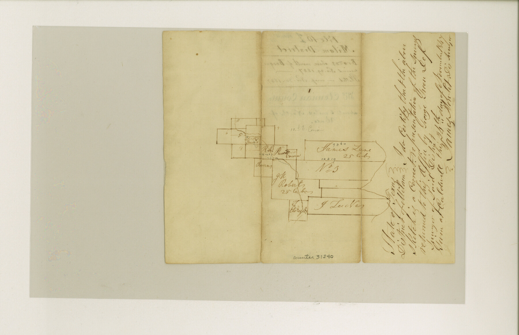
McLennan County Sketch File 5
[Two sketches of different areas in the western half of the county]
-
Map/Doc
31240
-
Collection
General Map Collection
-
People and Organizations
James Howlet (Surveyor/Engineer)
Chas. W. Pressler (Surveyor/Engineer)
-
Counties
McLennan
-
Subjects
Surveying Sketch File
-
Height x Width
11.0 x 17.0 inches
27.9 x 43.2 cm
-
Medium
paper, manuscript
-
Features
Bosque River
Brazos River
Part of: General Map Collection
Wood County Working Sketch 7

Print $20.00
- Digital $50.00
Wood County Working Sketch 7
1942
Size 41.0 x 37.7 inches
Map/Doc 62007
Flight Mission No. CRK-7P, Frame 131, Refugio County

Print $20.00
- Digital $50.00
Flight Mission No. CRK-7P, Frame 131, Refugio County
1956
Size 18.3 x 22.1 inches
Map/Doc 86954
Flight Mission No. DAG-18K, Frame 71, Matagorda County

Print $20.00
- Digital $50.00
Flight Mission No. DAG-18K, Frame 71, Matagorda County
1952
Size 16.3 x 16.3 inches
Map/Doc 86364
Matagorda County Working Sketch 6

Print $20.00
- Digital $50.00
Matagorda County Working Sketch 6
1950
Size 24.2 x 41.5 inches
Map/Doc 70864
Flight Mission No. DQO-1K, Frame 147, Galveston County

Print $20.00
- Digital $50.00
Flight Mission No. DQO-1K, Frame 147, Galveston County
1952
Size 18.8 x 22.4 inches
Map/Doc 85000
Township No. 1 South Range No. 24 West of the Indian Meridian

Print $20.00
- Digital $50.00
Township No. 1 South Range No. 24 West of the Indian Meridian
1875
Size 19.2 x 24.4 inches
Map/Doc 75173
Crane County Sketch File 21

Print $7.00
- Digital $50.00
Crane County Sketch File 21
1930
Size 11.4 x 8.9 inches
Map/Doc 19590
Real County Working Sketch 50

Print $20.00
- Digital $50.00
Real County Working Sketch 50
1957
Size 19.8 x 26.1 inches
Map/Doc 71942
Ward County Working Sketch 37

Print $20.00
- Digital $50.00
Ward County Working Sketch 37
1969
Size 31.3 x 46.9 inches
Map/Doc 72343
Liberty County Working Sketch 4

Print $20.00
- Digital $50.00
Liberty County Working Sketch 4
1901
Size 16.1 x 20.2 inches
Map/Doc 70463
McMullen County Sketch File 42

Print $6.00
- Digital $50.00
McMullen County Sketch File 42
1941
Size 14.2 x 8.9 inches
Map/Doc 31418
Crane County Working Sketch Graphic Index, Sheet A

Print $20.00
- Digital $50.00
Crane County Working Sketch Graphic Index, Sheet A
1945
Size 44.6 x 33.3 inches
Map/Doc 76507
You may also like
Bexar County Sketch File 58a

Print $4.00
- Digital $50.00
Bexar County Sketch File 58a
1847
Size 10.2 x 8.2 inches
Map/Doc 14574
Trinity River, Irving Sheet

Print $4.00
- Digital $50.00
Trinity River, Irving Sheet
1925
Size 20.7 x 17.9 inches
Map/Doc 65212
[H. & G. N. Block 1]
![90944, [H. & G. N. Block 1], Twichell Survey Records](https://historictexasmaps.com/wmedia_w700/maps/90944-1.tif.jpg)
Print $20.00
- Digital $50.00
[H. & G. N. Block 1]
1873
Size 17.7 x 14.3 inches
Map/Doc 90944
Schleicher County Working Sketch 16

Print $20.00
- Digital $50.00
Schleicher County Working Sketch 16
1942
Size 24.5 x 26.4 inches
Map/Doc 63818
Comanche County, Texas

Print $20.00
- Digital $50.00
Comanche County, Texas
1879
Size 23.5 x 28.4 inches
Map/Doc 702
Chambers County Sketch File 55

Print $10.00
- Digital $50.00
Chambers County Sketch File 55
1935
Size 14.3 x 8.6 inches
Map/Doc 18094
Flight Mission No. BRA-16M, Frame 59, Jefferson County

Print $20.00
- Digital $50.00
Flight Mission No. BRA-16M, Frame 59, Jefferson County
1953
Size 18.3 x 22.5 inches
Map/Doc 85676
Map of Tyler County, Texas

Print $20.00
- Digital $50.00
Map of Tyler County, Texas
1879
Size 28.6 x 22.8 inches
Map/Doc 720
Mills County Boundary File 8

Print $10.00
- Digital $50.00
Mills County Boundary File 8
Size 14.2 x 8.7 inches
Map/Doc 57313
Brewster County Rolled Sketch 98

Print $20.00
- Digital $50.00
Brewster County Rolled Sketch 98
1952
Size 29.3 x 38.0 inches
Map/Doc 8508
San Patricio County NRC Article 33.136 Location Key Sheet

Print $20.00
- Digital $50.00
San Patricio County NRC Article 33.136 Location Key Sheet
1975
Size 27.0 x 23.0 inches
Map/Doc 87914
Sutton County Sketch File JT

Print $12.00
- Digital $50.00
Sutton County Sketch File JT
Size 14.4 x 8.6 inches
Map/Doc 37453