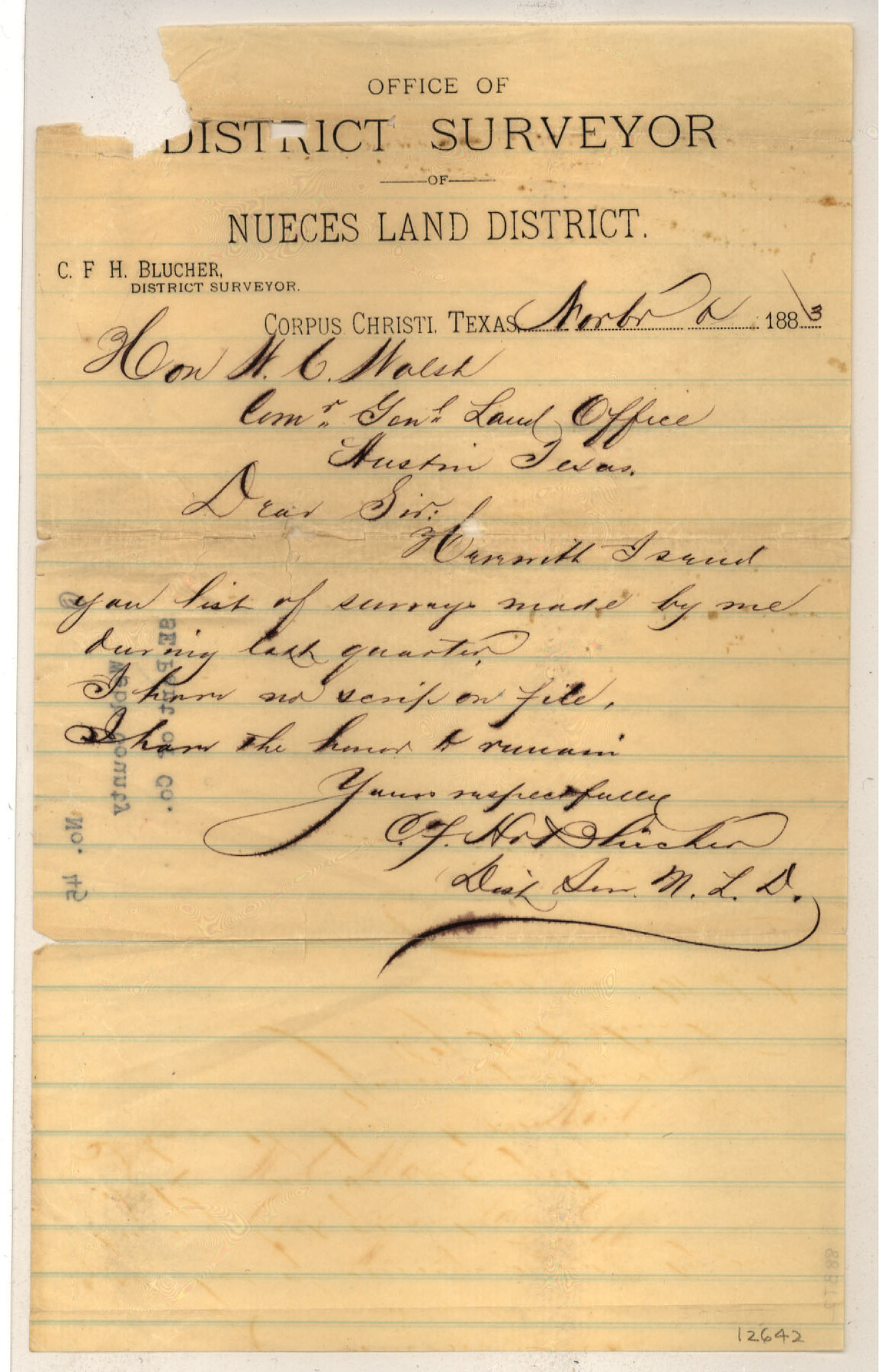
Webb County Sketch File 45
[Sketch and letter regarding surveys in the southeast part of the county]
-
Map/Doc
12642
-
Collection
General Map Collection
-
Object Dates
11/1/1883 (Creation Date)
11/9/1883 (File Date)
-
People and Organizations
C.F.H. Blucher (Surveyor/Engineer)
-
Counties
Webb
-
Subjects
Surveying Sketch File
-
Height x Width
17.5 x 22.5 inches
44.5 x 57.2 cm
-
Medium
paper, manuscript
Part of: General Map Collection
Flight Mission No. CGI-2N, Frame 186, Cameron County

Print $20.00
- Digital $50.00
Flight Mission No. CGI-2N, Frame 186, Cameron County
1954
Size 19.5 x 25.0 inches
Map/Doc 84546
Flight Mission No. CRE-2R, Frame 88, Jackson County

Print $20.00
- Digital $50.00
Flight Mission No. CRE-2R, Frame 88, Jackson County
1956
Size 15.9 x 15.9 inches
Map/Doc 85360
Culberson County Rolled Sketch 48

Print $335.00
- Digital $50.00
Culberson County Rolled Sketch 48
1960
Size 11.0 x 15.4 inches
Map/Doc 45339
Right-of-Way and Track Map, Texas State Railroad operated by the T. and N. O. R.R. Co.

Print $40.00
- Digital $50.00
Right-of-Way and Track Map, Texas State Railroad operated by the T. and N. O. R.R. Co.
1917
Size 24.8 x 56.3 inches
Map/Doc 64173

Map of Jack County

Print $40.00
- Digital $50.00
Map of Jack County
1895
Size 49.7 x 37.2 inches
Map/Doc 16858
Stephens County Sketch File 1B

Print $20.00
- Digital $50.00
Stephens County Sketch File 1B
Size 12.9 x 28.2 inches
Map/Doc 12348
Hale County Sketch File 22

Print $8.00
- Digital $50.00
Hale County Sketch File 22
1903
Size 11.1 x 8.6 inches
Map/Doc 24755
Upton County Sketch File 33

Print $20.00
- Digital $50.00
Upton County Sketch File 33
1939
Size 19.4 x 20.8 inches
Map/Doc 12524
Jefferson County NRC Article 33.136 Sketch 6

Print $4.00
- Digital $50.00
Jefferson County NRC Article 33.136 Sketch 6
2005
Size 14.1 x 8.6 inches
Map/Doc 83171
Flight Mission No. DQO-1K, Frame 92, Galveston County

Print $20.00
- Digital $50.00
Flight Mission No. DQO-1K, Frame 92, Galveston County
1952
Size 18.9 x 22.6 inches
Map/Doc 84988
Flight Mission No. 29300074, Harris County

Print $20.00
- Digital $50.00
Flight Mission No. 29300074, Harris County
1985
Size 10.4 x 10.4 inches
Map/Doc 85286
You may also like
Galveston County Sketch File 56

Print $4.00
- Digital $50.00
Galveston County Sketch File 56
1892
Size 11.2 x 8.8 inches
Map/Doc 23601
Flight Mission No. BRE-2P, Frame 69, Nueces County

Print $20.00
- Digital $50.00
Flight Mission No. BRE-2P, Frame 69, Nueces County
1956
Size 18.6 x 22.5 inches
Map/Doc 86764
The Republic County of Harris. Proposed, Late Fall 1837-May 15, 1838

Print $20.00
The Republic County of Harris. Proposed, Late Fall 1837-May 15, 1838
2020
Size 17.7 x 21.7 inches
Map/Doc 96162

Maps & Lists Showing Prison Lands (Oil & Gas) Leased as of June 1955

Digital $50.00
Maps & Lists Showing Prison Lands (Oil & Gas) Leased as of June 1955
Size 11.4 x 7.1 inches
Map/Doc 62866
Terrell County Working Sketch 1

Print $20.00
- Digital $50.00
Terrell County Working Sketch 1
1886
Size 27.5 x 24.4 inches
Map/Doc 62149
Navarro County Rolled Sketch 7

Print $20.00
- Digital $50.00
Navarro County Rolled Sketch 7
Size 45.0 x 34.6 inches
Map/Doc 10308
Pecos County Working Sketch 90

Print $40.00
- Digital $50.00
Pecos County Working Sketch 90
1964
Size 65.3 x 26.6 inches
Map/Doc 71562
Midland County Working Sketch 27

Print $20.00
- Digital $50.00
Midland County Working Sketch 27
1963
Size 41.6 x 38.9 inches
Map/Doc 71008
[Sketch of part of G. & M. Block 5, G. & M. Block 4, Block M19 and Block 21W]
![93085, [Sketch of part of G. & M. Block 5, G. & M. Block 4, Block M19 and Block 21W], Twichell Survey Records](https://historictexasmaps.com/wmedia_w700/maps/93085-1.tif.jpg)
Print $20.00
- Digital $50.00
[Sketch of part of G. & M. Block 5, G. & M. Block 4, Block M19 and Block 21W]
Size 23.1 x 17.8 inches
Map/Doc 93085
Potter County Boundary File 4

Print $30.00
- Digital $50.00
Potter County Boundary File 4
Size 14.6 x 9.3 inches
Map/Doc 57997
Portion of States Submerged Area in Matagorda Bay

Print $20.00
- Digital $50.00
Portion of States Submerged Area in Matagorda Bay
1921
Size 15.7 x 15.1 inches
Map/Doc 2950