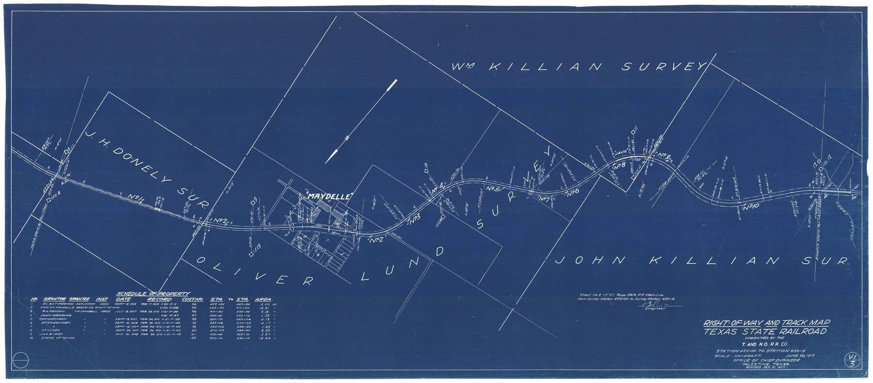
Right-of-Way and Track Map, Texas State Railroad operated by the T. and N. O. R.R. Co.
Station 422+40 to Station 633+18
Z-2-48
- 
                          Map/Doc64173
- 
                            CollectionGeneral Map Collection
- 
                            Object Dates1927/12/31 (Revision Date)1917/6/30 (Creation Date)
- 
                            CountiesCherokee
- 
                            SubjectsRailroads
- 
                            Height x Width24.8 x 56.3 inches63.0 x 143.0 cm
- 
                            Mediumblueprint/diazo
- 
                            Scale1" = 400'
- 
                            CommentsSee counter nos. 64171 through 64178 for all sheets.
- 
                            FeaturesT&NOTSRMaydelleJavaTalles Creek
Part of: General Map Collection
            Flight Mission No. BRE-1P, Frame 129, Nueces County


                                            Print $20.00                    
                                             -                         Digital $50.00                                    
                Flight Mission No. BRE-1P, Frame 129, Nueces County
1956
Size 18.5 x 22.6 inches
                                Map/Doc 86695
            
            Ft. W. & R. G. Ry. Right of Way Map, Chapin to Bluffdale, Hood County, Texas


                                            Print $40.00                    
                                             -                         Digital $50.00                                    
                Ft. W. & R. G. Ry. Right of Way Map, Chapin to Bluffdale, Hood County, Texas
1918
Size 36.5 x 50.5 inches
                                Map/Doc 64645
            
            Hunt County Working Sketch 3


                                            Print $20.00                    
                                             -                         Digital $50.00                                    
                Hunt County Working Sketch 3
1923
Size 20.6 x 28.2 inches
                                Map/Doc 66350
            
            Uvalde County Sketch File 32


                                            Print $12.00                    
                                             -                         Digital $50.00                                    
                Uvalde County Sketch File 32
2008
Size 8.5 x 11.0 inches
                                Map/Doc 89025
            
            Calhoun County Sketch File 9


                                            Print $14.00                    
                                             -                         Digital $50.00                                    
                Calhoun County Sketch File 9
1953
Size 11.5 x 14.0 inches
                                Map/Doc 35936
            
            [Map of Henderson County]
            
                                    ![76767, [Map of Henderson County], General Map Collection](https://historictexasmaps.com/wmedia_w700/maps/76767.tif.jpg) 


    ![76767, [Map of Henderson County], General Map Collection](https://historictexasmaps.com/wmedia_w700/maps/76767.tif.jpg) 
                                
            
                                            Print $20.00                    
                                             -                         Digital $50.00                                    
                [Map of Henderson County]
1854
Size 29.7 x 22.0 inches
                                Map/Doc 76767
            
            Crockett County Working Sketch 66


                                            Print $40.00                    
                                             -                         Digital $50.00                                    
                Crockett County Working Sketch 66
1959
Size 62.7 x 44.0 inches
                                Map/Doc 68399
            
            Taylor County Rolled Sketch 26


                                            Print $20.00                    
                                             -                         Digital $50.00                                    
                Taylor County Rolled Sketch 26
1982
Size 35.0 x 35.0 inches
                                Map/Doc 9987
            
            Bastrop County Working Sketch 3


                                            Print $20.00                    
                                             -                         Digital $50.00                                    
                Bastrop County Working Sketch 3
1921
Size 22.9 x 15.4 inches
                                Map/Doc 67303
            
            Copy of Surveyor's Field Book, Morris Browning - In Blocks 7, 5 & 4, I&GNRRCo., Hutchinson and Carson Counties, Texas


                                            Print $2.00                    
                                             -                         Digital $50.00                                    
                Copy of Surveyor's Field Book, Morris Browning - In Blocks 7, 5 & 4, I&GNRRCo., Hutchinson and Carson Counties, Texas
1888
Size 7.0 x 8.9 inches
                                Map/Doc 62277
            
            Winkler County Rolled Sketch 4


                                            Print $40.00                    
                                             -                         Digital $50.00                                    
                Winkler County Rolled Sketch 4
1927
Size 59.1 x 39.5 inches
                                Map/Doc 10147
            
            Outer Continental Shelf Leasing Maps (Texas Offshore Operations)


                                            Print $20.00                    
                                             -                         Digital $50.00                                    
                Outer Continental Shelf Leasing Maps (Texas Offshore Operations)
Size 17.7 x 14.3 inches
                                Map/Doc 75856
            You may also like
            Nolan County Working Sketch 8


                                            Print $40.00                    
                                             -                         Digital $50.00                                    
                Nolan County Working Sketch 8
1956
Size 70.8 x 33.0 inches
                                Map/Doc 71299
            
            Brewster County Rolled Sketch 28


                                            Print $20.00                    
                                             -                         Digital $50.00                                    
                Brewster County Rolled Sketch 28
1910
Size 25.6 x 29.4 inches
                                Map/Doc 5215
            
            Motley County Sketch File 33 (S)


                                            Print $6.00                    
                                             -                         Digital $50.00                                    
                Motley County Sketch File 33 (S)
1914
Size 7.4 x 8.5 inches
                                Map/Doc 32217
            
            Flight Mission No. DIX-8P, Frame 94, Aransas County


                                            Print $20.00                    
                                             -                         Digital $50.00                                    
                Flight Mission No. DIX-8P, Frame 94, Aransas County
1956
Size 18.5 x 22.3 inches
                                Map/Doc 83919
            
            Kimble County Working Sketch 36


                                            Print $40.00                    
                                             -                         Digital $50.00                                    
                Kimble County Working Sketch 36
1946
Size 53.6 x 43.1 inches
                                Map/Doc 70104
            
            Loving County Rolled Sketch 16


                                            Print $20.00                    
                                             -                         Digital $50.00                                    
                Loving County Rolled Sketch 16
2016
Size 36.3 x 24.6 inches
                                Map/Doc 94114
            
            Liberty County Boundary File 1


                                            Print $8.00                    
                                             -                         Digital $50.00                                    
                Liberty County Boundary File 1
Size 14.2 x 8.9 inches
                                Map/Doc 56289
            
            Map of Kimble County, Texas


                                            Print $20.00                    
                                             -                         Digital $50.00                                    
                Map of Kimble County, Texas
1879
Size 18.1 x 28.3 inches
                                Map/Doc 527
            
            Working Sketch in SW cor. of Coleman Co. showing the excess in the surveys fronting on the river and the relative position of surveys north of them according to latest data on file in the Genl. Land Office


                                            Print $20.00                    
                                             -                         Digital $50.00                                    
                Working Sketch in SW cor. of Coleman Co. showing the excess in the surveys fronting on the river and the relative position of surveys north of them according to latest data on file in the Genl. Land Office
1892
Size 18.8 x 14.1 inches
                                Map/Doc 441
            
            Borden County Boundary File 7


                                            Print $29.00                    
                                             -                         Digital $50.00                                    
                Borden County Boundary File 7
1965
Size 11.2 x 8.8 inches
                                Map/Doc 61161
            
            [Township 3 North, Block 34]
            
                                    ![91227, [Township 3 North, Block 34], Twichell Survey Records](https://historictexasmaps.com/wmedia_w700/maps/91227-1.tif.jpg) 


    ![91227, [Township 3 North, Block 34], Twichell Survey Records](https://historictexasmaps.com/wmedia_w700/maps/91227-1.tif.jpg) 
                                
            
                                            Print $2.00                    
                                             -                         Digital $50.00                                    
                [Township 3 North, Block 34]
Size 9.2 x 11.7 inches
                                Map/Doc 91227
            
            Typical Scenes of Wichita Falls and District


                                            Print $20.00                    
                                             -                         Digital $50.00                                    
                Typical Scenes of Wichita Falls and District
1927
Size 13.7 x 16.6 inches
                                Map/Doc 96761
            