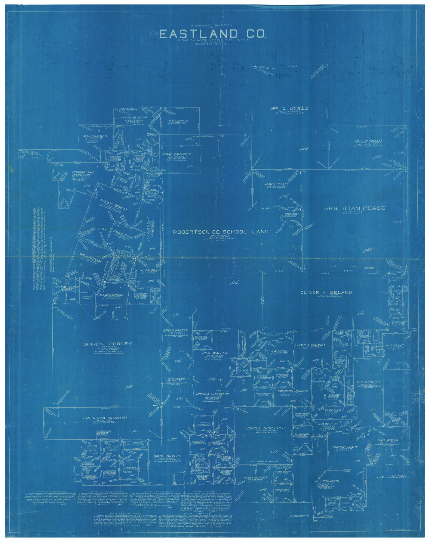
Eastland County Working Sketch 23
-
Map/Doc
68804
-
Collection
General Map Collection
-
Object Dates
7/30/1920 (Creation Date)
-
People and Organizations
Grady W. Davis (Draftsman)
-
Counties
Eastland
-
Subjects
Surveying Working Sketch
-
Height x Width
53.5 x 42.5 inches
135.9 x 108.0 cm
-
Scale
1" = 500 varas
Part of: General Map Collection
Real County Working Sketch 67

Print $20.00
- Digital $50.00
Real County Working Sketch 67
1970
Size 21.2 x 16.4 inches
Map/Doc 71959
Jeff Davis County Sketch File 1

Print $20.00
- Digital $50.00
Jeff Davis County Sketch File 1
Size 35.8 x 24.2 inches
Map/Doc 11855
Dimmit County Sketch File 20a

Print $2.00
- Digital $50.00
Dimmit County Sketch File 20a
Size 9.3 x 4.3 inches
Map/Doc 21103
McMullen County Working Sketch 57

Print $20.00
- Digital $50.00
McMullen County Working Sketch 57
1983
Size 29.5 x 18.8 inches
Map/Doc 70758

Carson County

Print $20.00
- Digital $50.00
Carson County
1932
Size 42.0 x 38.5 inches
Map/Doc 73100
Bailey County Sketch File 10

Print $4.00
- Digital $50.00
Bailey County Sketch File 10
Size 14.1 x 8.7 inches
Map/Doc 13965
Crockett County Sketch File 90

Print $40.00
- Digital $50.00
Crockett County Sketch File 90
1961
Size 14.7 x 23.5 inches
Map/Doc 11238
Supplemental Plat of a portion of T. 5S., R. 13W., Indian Mer., Oklahoma

Print $4.00
- Digital $50.00
Supplemental Plat of a portion of T. 5S., R. 13W., Indian Mer., Oklahoma
1922
Size 18.3 x 24.4 inches
Map/Doc 75154
Real County Working Sketch 26

Print $20.00
- Digital $50.00
Real County Working Sketch 26
1947
Size 28.7 x 28.1 inches
Map/Doc 71918
Map of Germany, Switzerland and Northern Italy engraved to illustrate Mitchell's school and family geography

Print $20.00
- Digital $50.00
Map of Germany, Switzerland and Northern Italy engraved to illustrate Mitchell's school and family geography
1840
Size 11.8 x 9.5 inches
Map/Doc 93504
Flight Mission No. DCL-7C, Frame 21, Kenedy County

Print $20.00
- Digital $50.00
Flight Mission No. DCL-7C, Frame 21, Kenedy County
1943
Size 15.3 x 15.2 inches
Map/Doc 86013
You may also like
Controlled Mosaic by Jack Amman Photogrammetric Engineers, Inc - Sheet 28

Print $20.00
- Digital $50.00
Controlled Mosaic by Jack Amman Photogrammetric Engineers, Inc - Sheet 28
1954
Size 20.0 x 24.0 inches
Map/Doc 83481
Map of Moser Ranch, Bowie County, Texas

Print $20.00
- Digital $50.00
Map of Moser Ranch, Bowie County, Texas
Size 29.0 x 27.4 inches
Map/Doc 73558
Flight Mission No. BQR-4K, Frame 65, Brazoria County

Print $20.00
- Digital $50.00
Flight Mission No. BQR-4K, Frame 65, Brazoria County
1952
Size 18.5 x 22.3 inches
Map/Doc 83998
Duval County Sketch File 66

Print $12.00
- Digital $50.00
Duval County Sketch File 66
1944
Size 14.5 x 8.8 inches
Map/Doc 21444
Flight Mission No. DQN-6K, Frame 13, Calhoun County

Print $20.00
- Digital $50.00
Flight Mission No. DQN-6K, Frame 13, Calhoun County
1953
Size 18.5 x 22.2 inches
Map/Doc 84435
Connected Map of Austin's Colony

Print $40.00
- Digital $50.00
Connected Map of Austin's Colony
1837
Size 90.8 x 85.6 inches
Map/Doc 1944

Flight Mission No. BRA-8M, Frame 78, Jefferson County

Print $20.00
- Digital $50.00
Flight Mission No. BRA-8M, Frame 78, Jefferson County
1953
Size 15.9 x 15.8 inches
Map/Doc 85598
Rio Grande Rectification Project, El Paso and Juarez Valley

Print $20.00
- Digital $50.00
Rio Grande Rectification Project, El Paso and Juarez Valley
1935
Size 10.7 x 29.7 inches
Map/Doc 60870
[Sketch showing parts of PSL Bloks Q, L, and P]
![89687, [Sketch showing parts of PSL Bloks Q, L, and P], Twichell Survey Records](https://historictexasmaps.com/wmedia_w700/maps/89687-1.tif.jpg)
Print $40.00
- Digital $50.00
[Sketch showing parts of PSL Bloks Q, L, and P]
Size 62.4 x 23.2 inches
Map/Doc 89687
Webb County Working Sketch 57

Print $20.00
- Digital $50.00
Webb County Working Sketch 57
1958
Size 24.9 x 38.0 inches
Map/Doc 72423
Lynn County Boundary File 10

Print $110.00
- Digital $50.00
Lynn County Boundary File 10
Size 14.3 x 8.7 inches
Map/Doc 56709