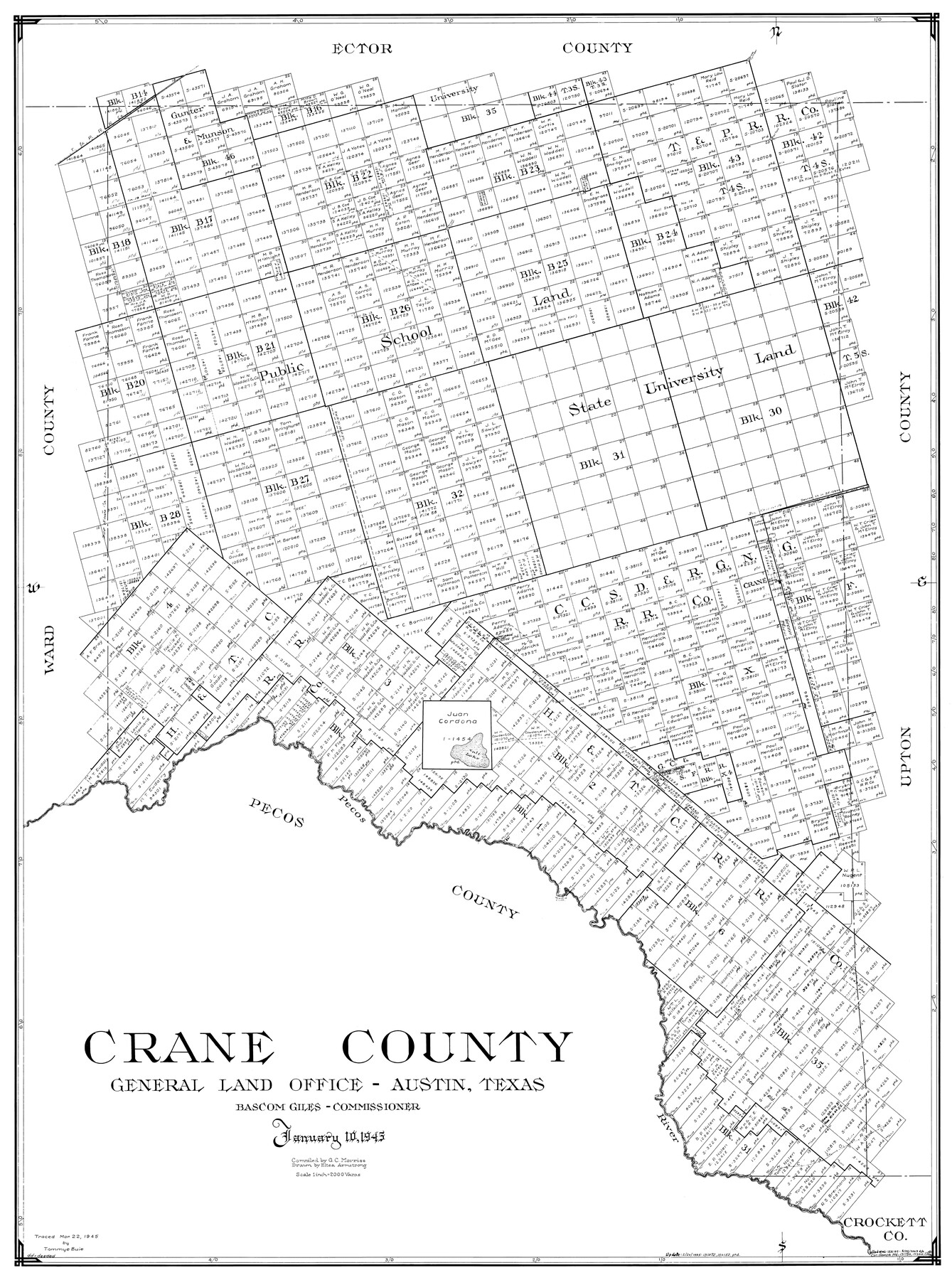
Crane County
-
Map/Doc
77251
-
Collection
General Map Collection
-
Object Dates
1945/1/10 (Creation Date)
-
People and Organizations
Eltea Armstrong (Draftsman)
G.C. Morriss (Compiler)
-
Counties
Crane
-
Subjects
County
-
Height x Width
43.5 x 32.6 inches
110.5 x 82.8 cm
Part of: General Map Collection
Sterling County Rolled Sketch 15

Print $20.00
- Digital $50.00
Sterling County Rolled Sketch 15
Size 30.0 x 31.2 inches
Map/Doc 9947
Brazos River, Widths of Floodways/Brazos and Navasota Rivers

Print $20.00
- Digital $50.00
Brazos River, Widths of Floodways/Brazos and Navasota Rivers
1921
Size 38.1 x 24.5 inches
Map/Doc 65292
Kerr County Boundary File 6

Print $8.00
- Digital $50.00
Kerr County Boundary File 6
Size 14.2 x 8.7 inches
Map/Doc 64822
Midland County Working Sketch 18

Print $40.00
- Digital $50.00
Midland County Working Sketch 18
1956
Size 26.5 x 49.5 inches
Map/Doc 70998
Jefferson County Working Sketch 10

Print $40.00
- Digital $50.00
Jefferson County Working Sketch 10
1942
Size 35.0 x 49.4 inches
Map/Doc 66553
Coryell County Working Sketch 26

Print $20.00
- Digital $50.00
Coryell County Working Sketch 26
1988
Size 30.7 x 30.6 inches
Map/Doc 68233
Boundary and Ownership map, Laguna Atascosa National Wildlife Refuge, Cameron and Willacy Counties, Texas

Print $40.00
- Digital $50.00
Boundary and Ownership map, Laguna Atascosa National Wildlife Refuge, Cameron and Willacy Counties, Texas
Size 72.7 x 43.0 inches
Map/Doc 60396
Flight Mission No. BRE-2P, Frame 77, Nueces County

Print $20.00
- Digital $50.00
Flight Mission No. BRE-2P, Frame 77, Nueces County
1956
Size 18.4 x 22.2 inches
Map/Doc 86772
Upshur County Rolled Sketch 5

Print $20.00
- Digital $50.00
Upshur County Rolled Sketch 5
2000
Size 35.2 x 24.4 inches
Map/Doc 8064
Uvalde County Sketch File 22

Print $30.00
- Digital $50.00
Uvalde County Sketch File 22
1919
Size 9.7 x 8.6 inches
Map/Doc 39008
Duval County Sketch File 53

Print $4.00
- Digital $50.00
Duval County Sketch File 53
1937
Size 11.6 x 7.3 inches
Map/Doc 21416
Nueces County Sketch File 18

Print $4.00
- Digital $50.00
Nueces County Sketch File 18
1874
Size 10.2 x 7.2 inches
Map/Doc 32549
You may also like
Callahan County Sketch File 16

Print $4.00
- Digital $50.00
Callahan County Sketch File 16
Size 14.6 x 8.7 inches
Map/Doc 35895
Ochiltree County

Print $20.00
- Digital $50.00
Ochiltree County
Size 14.3 x 16.5 inches
Map/Doc 91491
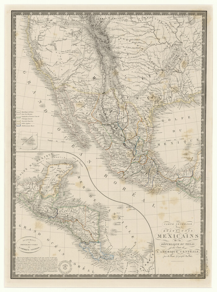
Carte Générale des États-Unis Mexicains de la République du Texas et des Etats de L'Amérique Centrale
Print $20.00
- Digital $50.00
Carte Générale des États-Unis Mexicains de la République du Texas et des Etats de L'Amérique Centrale
1844
Size 21.9 x 16.3 inches
Map/Doc 97532
Ward County Working Sketch 40

Print $20.00
- Digital $50.00
Ward County Working Sketch 40
1969
Size 24.4 x 45.7 inches
Map/Doc 72346
Louisiana and Texas Intracoastal Waterway - Entrance near Port O'Connor, Texas, Survey of September, 1940

Print $20.00
- Digital $50.00
Louisiana and Texas Intracoastal Waterway - Entrance near Port O'Connor, Texas, Survey of September, 1940
1940
Size 31.2 x 41.5 inches
Map/Doc 61822
Map of Bexar County, Texas

Print $20.00
- Digital $50.00
Map of Bexar County, Texas
1879
Size 25.1 x 29.7 inches
Map/Doc 530
Sabine River, Composite Sheet

Print $40.00
- Digital $50.00
Sabine River, Composite Sheet
Size 38.5 x 52.7 inches
Map/Doc 65133
Lavaca County Working Sketch 23

Print $20.00
- Digital $50.00
Lavaca County Working Sketch 23
1985
Size 37.8 x 39.8 inches
Map/Doc 70376
Brewster County Working Sketch 29

Print $20.00
- Digital $50.00
Brewster County Working Sketch 29
1941
Size 19.1 x 31.2 inches
Map/Doc 67563
Zavala County Sketch File 46

Print $20.00
- Digital $50.00
Zavala County Sketch File 46
1937
Size 16.7 x 18.8 inches
Map/Doc 12734
Goliad County Sketch File X

Print $10.00
- Digital $50.00
Goliad County Sketch File X
1893
Size 8.3 x 12.8 inches
Map/Doc 24332
The Mexican Municipality of Brazoria. December 28, 1834

Print $20.00
The Mexican Municipality of Brazoria. December 28, 1834
2020
Size 16.5 x 21.7 inches
Map/Doc 96017