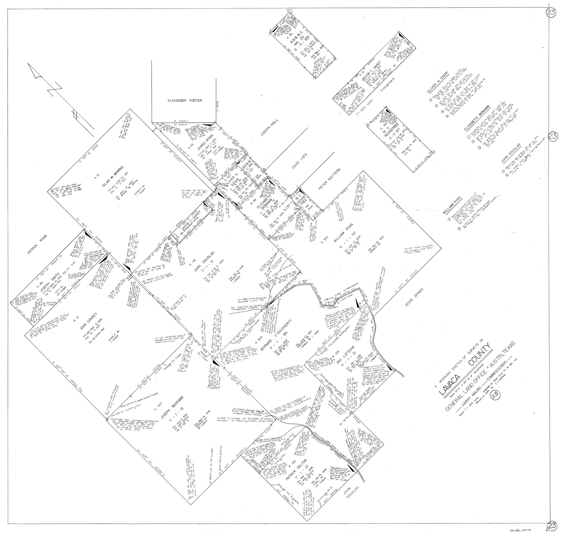
Lavaca County Working Sketch 23
-
Map/Doc
70376
-
Collection
General Map Collection
-
Object Dates
2/4/1985 (Creation Date)
-
People and Organizations
C.J. Huffman (Draftsman)
-
Counties
Lavaca
-
Subjects
Surveying Working Sketch
-
Height x Width
37.8 x 39.8 inches
96.0 x 101.1 cm
-
Scale
1" = 600 varas
Part of: General Map Collection
Pecos County Working Sketch 135

Print $20.00
- Digital $50.00
Pecos County Working Sketch 135
1979
Size 46.4 x 37.3 inches
Map/Doc 71609
Wise County Sketch File 42

Print $4.00
- Digital $50.00
Wise County Sketch File 42
1876
Size 8.0 x 6.5 inches
Map/Doc 40601
Clay County Sketch File 29

Print $16.00
- Digital $50.00
Clay County Sketch File 29
Size 11.3 x 8.7 inches
Map/Doc 18448
Matagorda Light to Aransas Pass

Print $20.00
- Digital $50.00
Matagorda Light to Aransas Pass
1924
Size 35.9 x 44.6 inches
Map/Doc 73391
Medina County

Print $40.00
- Digital $50.00
Medina County
1915
Size 50.1 x 42.1 inches
Map/Doc 66924
Travis County State Real Property Sketch 16

Print $20.00
- Digital $50.00
Travis County State Real Property Sketch 16
2009
Size 47.8 x 36.0 inches
Map/Doc 90087
Nueces County Rolled Sketch 13

Print $20.00
- Digital $50.00
Nueces County Rolled Sketch 13
1930
Size 26.5 x 18.5 inches
Map/Doc 6869
Menard County Sketch File 2

Print $22.00
- Digital $50.00
Menard County Sketch File 2
1881
Size 7.9 x 12.8 inches
Map/Doc 31486
Rusk County Sketch File 19a

Print $4.00
Rusk County Sketch File 19a
1860
Size 8.2 x 6.6 inches
Map/Doc 35528
Val Verde County Rolled Sketch 60

Print $20.00
- Digital $50.00
Val Verde County Rolled Sketch 60
1951
Size 32.4 x 20.4 inches
Map/Doc 8127

Terrell County Sketch File 33

Print $20.00
- Digital $50.00
Terrell County Sketch File 33
1924
Size 18.2 x 27.6 inches
Map/Doc 12427
You may also like
Map of Sabine County

Print $20.00
- Digital $50.00
Map of Sabine County
1896
Size 25.8 x 17.9 inches
Map/Doc 63012
Williamson County Sketch File 26

Print $30.00
- Digital $50.00
Williamson County Sketch File 26
1853
Size 14.2 x 8.8 inches
Map/Doc 40367
T and P as Surveyed January 1876, Blocks 35-36

Print $40.00
- Digital $50.00
T and P as Surveyed January 1876, Blocks 35-36
1876
Size 29.0 x 95.2 inches
Map/Doc 93184

Coleman County Working Sketch 16

Print $20.00
- Digital $50.00
Coleman County Working Sketch 16
1950
Size 41.7 x 35.7 inches
Map/Doc 68082
Flight Mission No. CRC-6R, Frame 13, Chambers County

Print $20.00
- Digital $50.00
Flight Mission No. CRC-6R, Frame 13, Chambers County
1956
Size 18.6 x 22.3 inches
Map/Doc 84967
Galveston County NRC Article 33.136 Location Key Sheet

Print $20.00
- Digital $50.00
Galveston County NRC Article 33.136 Location Key Sheet
1994
Size 27.0 x 21.8 inches
Map/Doc 77021
Dickens County

Print $20.00
- Digital $50.00
Dickens County
1891
Size 27.7 x 21.9 inches
Map/Doc 66804
Kimble County Rolled Sketch 35

Print $20.00
- Digital $50.00
Kimble County Rolled Sketch 35
1978
Size 20.0 x 19.6 inches
Map/Doc 6525
Flight Mission No. DQO-7K, Frame 74, Galveston County

Print $20.00
- Digital $50.00
Flight Mission No. DQO-7K, Frame 74, Galveston County
1952
Size 18.9 x 22.5 inches
Map/Doc 85101
Starr County Rolled Sketch 8

Print $20.00
- Digital $50.00
Starr County Rolled Sketch 8
Size 21.5 x 29.6 inches
Map/Doc 7796
The Judicial District/County of Neches. Abolished, Spring 1842

Print $20.00
The Judicial District/County of Neches. Abolished, Spring 1842
2020
Size 15.5 x 21.7 inches
Map/Doc 96339