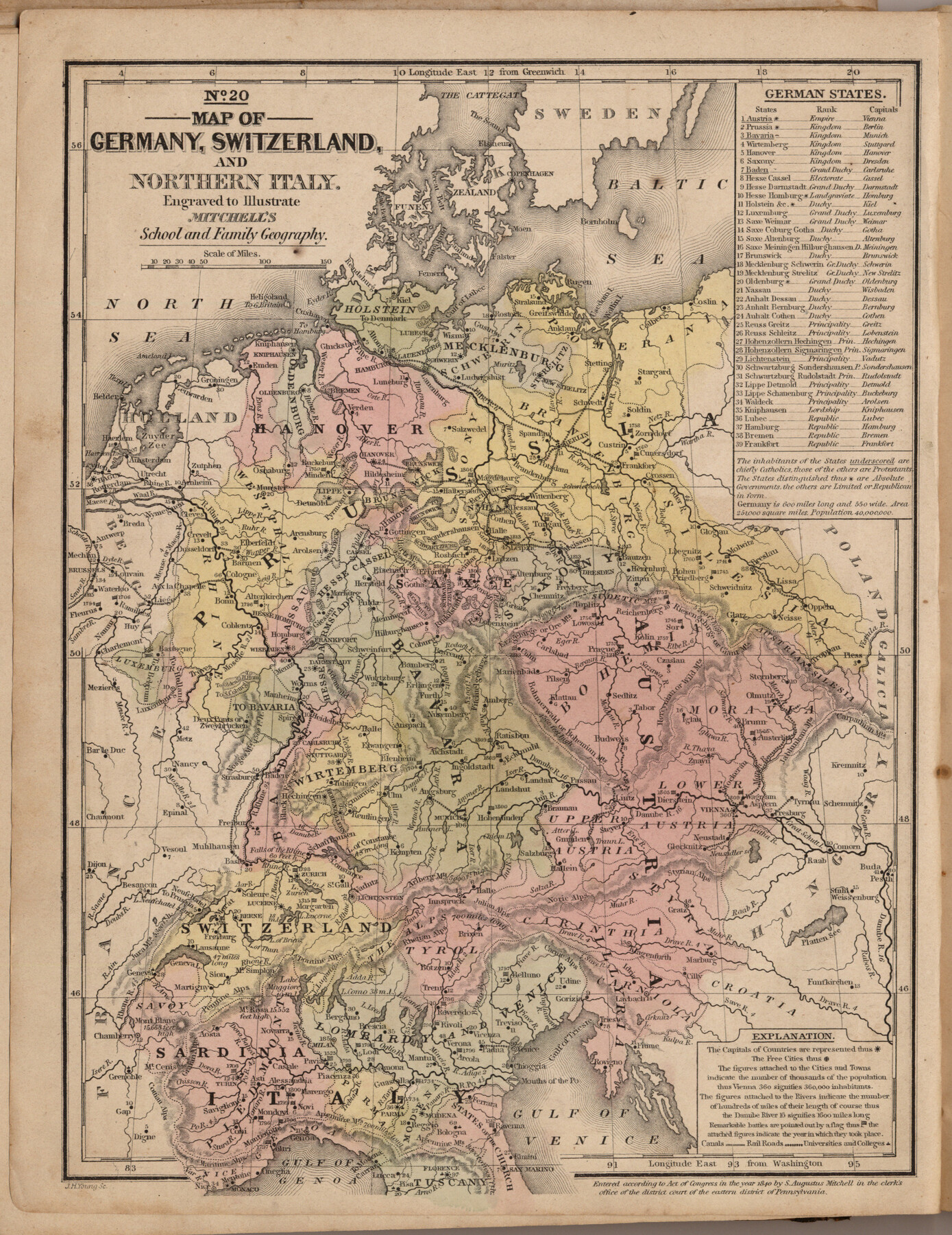
Map of Germany, Switzerland and Northern Italy engraved to illustrate Mitchell's school and family geography
Mitchell's school atlas map no. 20
-
Map/Doc
93504
-
Collection
General Map Collection
-
Object Dates
1840 (Creation Date)
2013/7/12 (File Date)
-
People and Organizations
Thomas, Cowperthwait and Co. (Publisher)
J. H. Young (Printer)
Galen Greaser (Donor)
S. Augustus Mitchell (Author)
-
Subjects
Atlas Europe
-
Height x Width
11.8 x 9.5 inches
30.0 x 24.1 cm
-
Comments
Donated by Galen Greaser in 2009. Map is part of volume: "Mitchell's school atlas: comprising the maps, etc., designed to illustrate Mitchell's school and family geography". See 93491 for complete atlas.
Related maps
Mitchell's school atlas: comprising the maps, etc., designed to illustrate Mitchell's school and family geography

Print $370.00
- Digital $50.00
Mitchell's school atlas: comprising the maps, etc., designed to illustrate Mitchell's school and family geography
1851
Size 12.0 x 9.6 inches
Map/Doc 93491
Part of: General Map Collection
Mason County Rolled Sketch 3

Print $20.00
- Digital $50.00
Mason County Rolled Sketch 3
1965
Size 30.3 x 22.8 inches
Map/Doc 6676
Harris County Working Sketch 70

Print $20.00
- Digital $50.00
Harris County Working Sketch 70
1956
Size 25.5 x 32.9 inches
Map/Doc 65962
Flight Mission No. CUG-2P, Frame 8, Kleberg County

Print $20.00
- Digital $50.00
Flight Mission No. CUG-2P, Frame 8, Kleberg County
1956
Size 18.5 x 22.2 inches
Map/Doc 86180
Hardin County Sketch File 2

Print $7.00
- Digital $50.00
Hardin County Sketch File 2
Size 12.7 x 8.4 inches
Map/Doc 25083
Map of Eastland County, the portion on the waters of Colorado River, Travis - the balance, Milam Land District

Print $20.00
- Digital $50.00
Map of Eastland County, the portion on the waters of Colorado River, Travis - the balance, Milam Land District
1860
Size 23.8 x 21.5 inches
Map/Doc 3501
La Salle County Working Sketch 1

Print $20.00
- Digital $50.00
La Salle County Working Sketch 1
1929
Size 24.2 x 23.1 inches
Map/Doc 70302
Presidio County Sketch File 66

Print $6.00
- Digital $50.00
Presidio County Sketch File 66
1940
Size 11.4 x 8.7 inches
Map/Doc 34656
Val Verde County Rolled Sketch JR

Print $20.00
- Digital $50.00
Val Verde County Rolled Sketch JR
1938
Size 35.9 x 31.1 inches
Map/Doc 10080
San Augustine County Sketch File 12

Print $4.00
San Augustine County Sketch File 12
Size 12.2 x 7.9 inches
Map/Doc 35656
Diefert Situs Orbis Hydrographorum ab eo quem Ptolomeus Posuit

Print $20.00
- Digital $50.00
Diefert Situs Orbis Hydrographorum ab eo quem Ptolomeus Posuit
1522
Size 13.9 x 19.1 inches
Map/Doc 96578
Llano County Boundary File 3

Print $42.00
- Digital $50.00
Llano County Boundary File 3
Size 14.1 x 8.7 inches
Map/Doc 56449
Map of Wise County

Print $20.00
- Digital $50.00
Map of Wise County
1895
Size 41.7 x 37.5 inches
Map/Doc 63133
You may also like
Flight Mission No. DIX-6P, Frame 115, Aransas County

Print $20.00
- Digital $50.00
Flight Mission No. DIX-6P, Frame 115, Aransas County
1956
Size 19.3 x 22.8 inches
Map/Doc 83821
Houston Ship Channel, Alexander Island to Carpenter Bayou

Print $40.00
- Digital $50.00
Houston Ship Channel, Alexander Island to Carpenter Bayou
1989
Size 35.4 x 49.3 inches
Map/Doc 69915
Hemphill County Boundary File 1

Print $18.00
- Digital $50.00
Hemphill County Boundary File 1
Size 9.0 x 3.9 inches
Map/Doc 54612
Medina County Working Sketch 27

Print $20.00
- Digital $50.00
Medina County Working Sketch 27
1985
Size 22.8 x 24.8 inches
Map/Doc 70942
Guadalupe County Rolled Sketch 1

Print $20.00
- Digital $50.00
Guadalupe County Rolled Sketch 1
1954
Size 33.1 x 38.8 inches
Map/Doc 6044
El Paso County Working Sketch 29

Print $40.00
- Digital $50.00
El Paso County Working Sketch 29
1967
Size 43.0 x 64.8 inches
Map/Doc 69051
Scurry County Rolled Sketch 1

Print $40.00
- Digital $50.00
Scurry County Rolled Sketch 1
Size 70.5 x 44.9 inches
Map/Doc 9910
Greer County Sketch File 4

Print $4.00
- Digital $50.00
Greer County Sketch File 4
1883
Size 8.6 x 5.5 inches
Map/Doc 24519


Trinity River, Bazzette Sheet

Print $20.00
- Digital $50.00
Trinity River, Bazzette Sheet
1925
Size 27.4 x 23.6 inches
Map/Doc 69692
