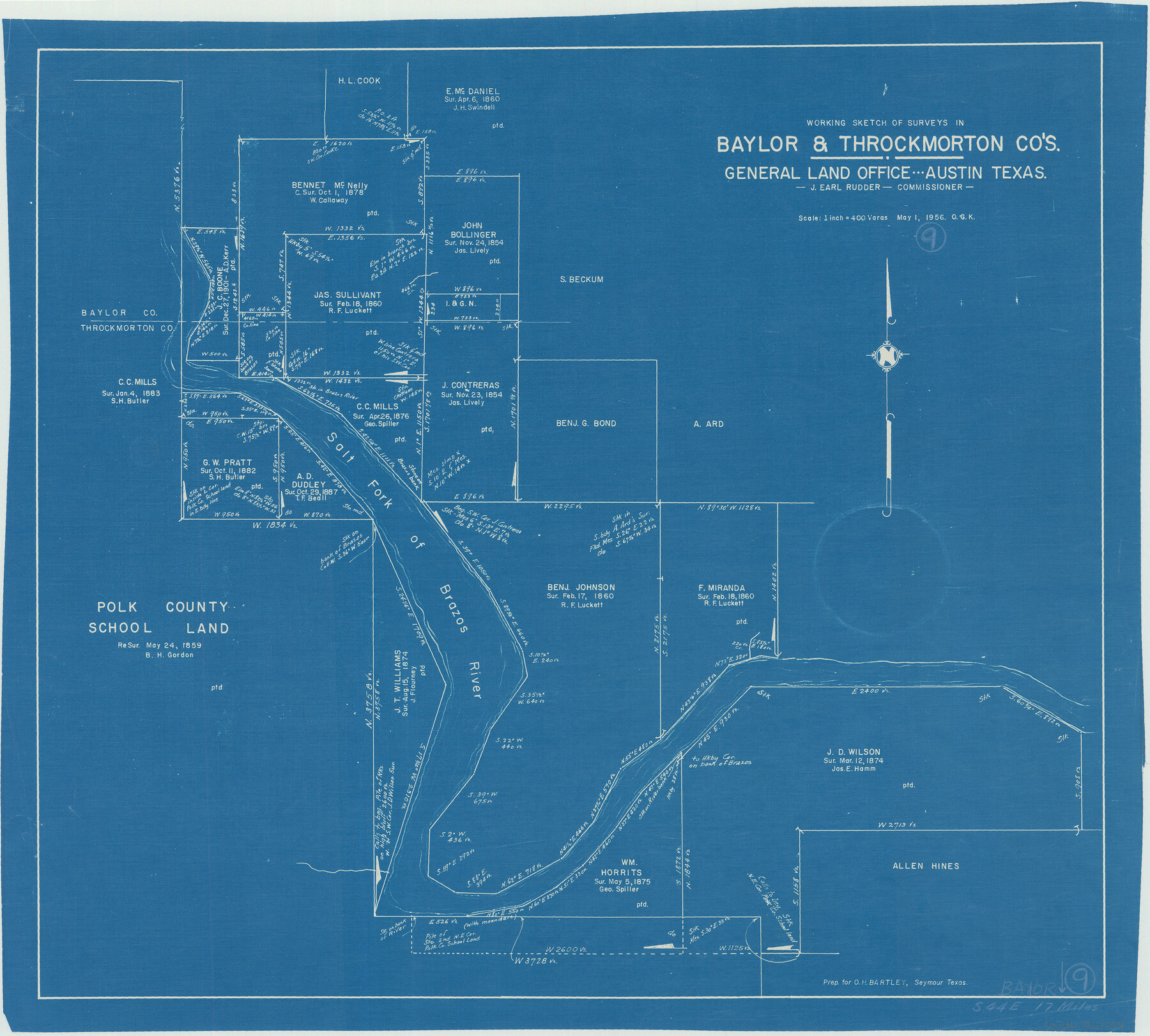
Baylor County Working Sketch 9
-
Map/Doc
67294
-
Collection
General Map Collection
-
Object Dates
5/1/1956 (Creation Date)
-
People and Organizations
J. Earl Rudder (GLO Commissioner)
Otto G. Kurio (Draftsman)
-
Counties
Baylor
-
Subjects
Surveying Working Sketch
-
Height x Width
24.7 x 27.4 inches
62.7 x 69.6 cm
-
Scale
1" = 400 varas
-
Comments
Surveys located about 17 miles South 44 degrees East of Seymour, Texas.
Part of: General Map Collection
El Paso County Rolled Sketch 38
Print $40.00
- Digital $50.00
El Paso County Rolled Sketch 38
1922
Size 14.1 x 61.3 inches
Map/Doc 8866
Map of Bowie County

Print $20.00
- Digital $50.00
Map of Bowie County
1841
Size 17.8 x 21.8 inches
Map/Doc 3316
Angelina County Sketch File 13

Print $4.00
- Digital $50.00
Angelina County Sketch File 13
1860
Size 13.0 x 8.2 inches
Map/Doc 12957
Throckmorton County Boundary File 3

Print $40.00
- Digital $50.00
Throckmorton County Boundary File 3
Size 18.9 x 17.9 inches
Map/Doc 59281
Van Zandt County Working Sketch 6a

Print $40.00
- Digital $50.00
Van Zandt County Working Sketch 6a
1941
Size 57.6 x 30.1 inches
Map/Doc 72255
Crockett County Rolled Sketch 63

Print $20.00
- Digital $50.00
Crockett County Rolled Sketch 63
1947
Size 18.9 x 30.8 inches
Map/Doc 5606
Culberson County Sketch File RJ

Print $20.00
- Digital $50.00
Culberson County Sketch File RJ
1927
Size 16.9 x 24.4 inches
Map/Doc 5789
Travis County Sketch File 4

Print $9.00
- Digital $50.00
Travis County Sketch File 4
1853
Size 13.1 x 8.2 inches
Map/Doc 38275
Wise County Working Sketch 26

Print $20.00
- Digital $50.00
Wise County Working Sketch 26
1987
Size 25.8 x 33.7 inches
Map/Doc 72640
Flight Mission No. BRA-16M, Frame 63, Jefferson County

Print $20.00
- Digital $50.00
Flight Mission No. BRA-16M, Frame 63, Jefferson County
1953
Size 18.6 x 22.3 inches
Map/Doc 85680
Taylor County Sketch File 15

Print $12.00
- Digital $50.00
Taylor County Sketch File 15
1881
Size 10.1 x 8.1 inches
Map/Doc 37805
Gulf Coast of the United States, Key West to Rio Grande

Print $20.00
- Digital $50.00
Gulf Coast of the United States, Key West to Rio Grande
1892
Size 27.3 x 18.3 inches
Map/Doc 72671
You may also like
Rusk County Sketch File 38

Print $6.00
Rusk County Sketch File 38
1951
Size 11.3 x 8.8 inches
Map/Doc 35576
Walker County Working Sketch 16

Print $20.00
- Digital $50.00
Walker County Working Sketch 16
1983
Size 36.5 x 42.4 inches
Map/Doc 72296
Liberty County Sketch File 46

Print $42.00
- Digital $50.00
Liberty County Sketch File 46
1860
Size 13.4 x 12.2 inches
Map/Doc 30005
Kent County Working Sketch 21

Print $20.00
- Digital $50.00
Kent County Working Sketch 21
1981
Size 43.5 x 37.5 inches
Map/Doc 70028
Terrell County Rolled Sketch 12

Print $20.00
- Digital $50.00
Terrell County Rolled Sketch 12
Size 37.1 x 31.5 inches
Map/Doc 7926
Midland County Working Sketch 25

Print $40.00
- Digital $50.00
Midland County Working Sketch 25
1957
Size 58.3 x 49.1 inches
Map/Doc 71006
San Jacinto County Working Sketch 44

Print $20.00
- Digital $50.00
San Jacinto County Working Sketch 44
1981
Size 20.6 x 11.4 inches
Map/Doc 63758
Presidio County Working Sketch 107

Print $40.00
- Digital $50.00
Presidio County Working Sketch 107
1980
Size 36.0 x 57.3 inches
Map/Doc 71784

Flight Mission No. CLL-1N, Frame 81, Willacy County

Print $20.00
- Digital $50.00
Flight Mission No. CLL-1N, Frame 81, Willacy County
1954
Size 18.3 x 22.1 inches
Map/Doc 87027
Map of Jefferson County

Print $20.00
- Digital $50.00
Map of Jefferson County
1840
Size 32.7 x 23.4 inches
Map/Doc 3725
Washington County

Print $20.00
- Digital $50.00
Washington County
1920
Size 32.5 x 47.2 inches
Map/Doc 16918