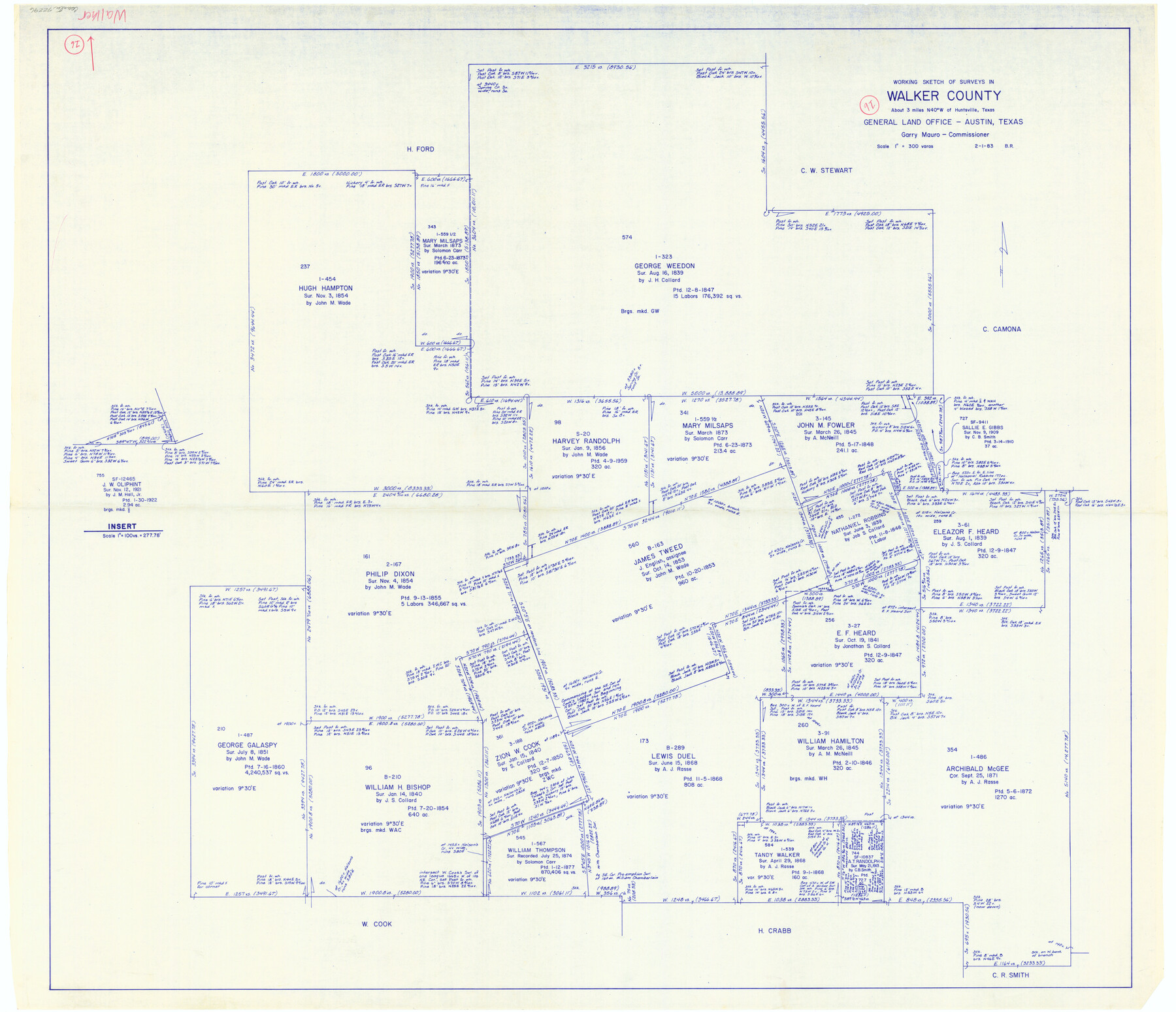
Walker County Working Sketch 16
-
Map/Doc
72296
-
Collection
General Map Collection
-
Object Dates
2/1/1983 (Creation Date)
-
People and Organizations
Beverly Robison (Draftsman)
-
Counties
Walker
-
Subjects
Surveying Working Sketch
-
Height x Width
36.5 x 42.4 inches
92.7 x 107.7 cm
-
Scale
1" = 300 varas
Part of: General Map Collection
Terry County Working Sketch Graphic Index

Print $20.00
- Digital $50.00
Terry County Working Sketch Graphic Index
1970
Size 41.2 x 33.8 inches
Map/Doc 76712
Brewster County Sketch File S-2

Print $16.00
- Digital $50.00
Brewster County Sketch File S-2
1910
Size 17.0 x 11.0 inches
Map/Doc 15731
Roberts County Rolled Sketch 1

Print $20.00
- Digital $50.00
Roberts County Rolled Sketch 1
Size 18.4 x 23.5 inches
Map/Doc 7510
Map showing state tracts in E. part of Corpus Christi Bay and surveys on Harbor Island & Corpus Christi channel

Print $40.00
- Digital $50.00
Map showing state tracts in E. part of Corpus Christi Bay and surveys on Harbor Island & Corpus Christi channel
1978
Size 53.4 x 37.7 inches
Map/Doc 2501
Mason County Working Sketch 6

Print $20.00
- Digital $50.00
Mason County Working Sketch 6
1940
Size 17.9 x 11.1 inches
Map/Doc 70842
Scurry County Sketch File 5

Print $4.00
- Digital $50.00
Scurry County Sketch File 5
1990
Size 14.4 x 8.9 inches
Map/Doc 36568
Hill County Sketch File 24

Print $40.00
- Digital $50.00
Hill County Sketch File 24
Size 15.6 x 13.8 inches
Map/Doc 26516
Bailey County

Print $20.00
- Digital $50.00
Bailey County
1956
Size 47.0 x 30.0 inches
Map/Doc 77206
Map of Texas with Parts of the Adjoining States

Print $20.00
- Digital $50.00
Map of Texas with Parts of the Adjoining States
1837
Size 31.5 x 24.9 inches
Map/Doc 2114
Map of the Passo Cavallo

Print $20.00
- Digital $50.00
Map of the Passo Cavallo
1853
Size 18.0 x 27.0 inches
Map/Doc 73011
Reagan County Rolled Sketch 34

Print $40.00
- Digital $50.00
Reagan County Rolled Sketch 34
1956
Size 53.2 x 40.3 inches
Map/Doc 9829
Right of Way and Track Map International & Gt Northern Ry. operated by the International & Gt. Northern Ry. Co., San Antonio Division

Print $40.00
- Digital $50.00
Right of Way and Track Map International & Gt Northern Ry. operated by the International & Gt. Northern Ry. Co., San Antonio Division
1917
Size 25.5 x 57.8 inches
Map/Doc 64789
You may also like
Topographical Map for Commerce of Dallas, Texas

Print $20.00
- Digital $50.00
Topographical Map for Commerce of Dallas, Texas
1890
Size 26.3 x 20.6 inches
Map/Doc 96792
Kimble County Sketch File 17

Print $17.00
- Digital $50.00
Kimble County Sketch File 17
Size 11.5 x 8.5 inches
Map/Doc 28947
Grant of Miguel Rabago

Print $2.00
- Digital $50.00
Grant of Miguel Rabago
Size 8.6 x 8.4 inches
Map/Doc 76047
McMullen County Working Sketch 3

Print $20.00
- Digital $50.00
McMullen County Working Sketch 3
1922
Size 21.1 x 10.8 inches
Map/Doc 70704
Reagan County Sketch File 5

Print $12.00
- Digital $50.00
Reagan County Sketch File 5
1927
Size 11.2 x 8.7 inches
Map/Doc 34980
Wheeler County Sketch File 8

Print $6.00
- Digital $50.00
Wheeler County Sketch File 8
1935
Size 11.4 x 8.8 inches
Map/Doc 40005
Flight Mission No. BRA-16M, Frame 129, Jefferson County

Print $20.00
- Digital $50.00
Flight Mission No. BRA-16M, Frame 129, Jefferson County
1953
Size 18.4 x 22.7 inches
Map/Doc 85739
Duval County Rolled Sketch 37

Print $20.00
- Digital $50.00
Duval County Rolled Sketch 37
1952
Size 29.2 x 24.6 inches
Map/Doc 5753
Mills County Working Sketch 24

Print $20.00
- Digital $50.00
Mills County Working Sketch 24
1988
Size 40.3 x 36.5 inches
Map/Doc 71054
Spade Ranch Hockley County, Texas

Print $3.00
- Digital $50.00
Spade Ranch Hockley County, Texas
1948
Size 17.6 x 7.7 inches
Map/Doc 92226
Flight Mission No. CUG-1P, Frame 73, Kleberg County

Print $20.00
- Digital $50.00
Flight Mission No. CUG-1P, Frame 73, Kleberg County
1956
Size 18.4 x 22.5 inches
Map/Doc 86138
Dimmit County Rolled Sketch 18

Print $20.00
- Digital $50.00
Dimmit County Rolled Sketch 18
1978
Size 20.2 x 26.0 inches
Map/Doc 5725