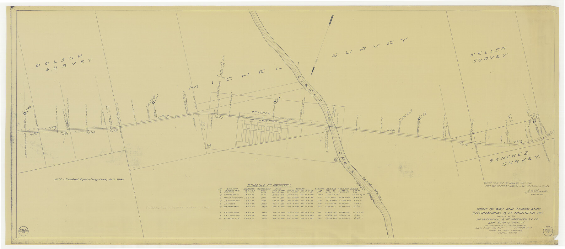
Right of Way and Track Map International & Gt Northern Ry. operated by the International & Gt. Northern Ry. Co., San Antonio Division
Station 12721+70 to Station 12935+22
Z-2-181
-
Map/Doc
64789
-
Collection
General Map Collection
-
Object Dates
1923/7/10 (Revision Date)
1917/6/30 (Creation Date)
-
People and Organizations
J. C. Resch (Surveyor/Engineer)
-
Counties
Comal Bexar
-
Subjects
Railroads
-
Height x Width
25.5 x 57.8 inches
64.8 x 146.8 cm
-
Medium
blueprint/diazo
-
Scale
1" = 400 feet
-
Comments
See counter nos. 64586 through 64589, 64787, and 64788 for other sheets of the map.
-
Features
I&GN
Cibolo Creek
Bracken
[Railroad line] to Austin
[Railroad line] to San Antonio
Part of: General Map Collection
Burnet County Working Sketch 25

Print $20.00
- Digital $50.00
Burnet County Working Sketch 25
2000
Size 24.2 x 30.3 inches
Map/Doc 67868
Stonewall County Working Sketch 1

Print $20.00
- Digital $50.00
Stonewall County Working Sketch 1
1910
Size 30.7 x 22.8 inches
Map/Doc 63995
Gregg County Working Sketch 11a

Print $20.00
- Digital $50.00
Gregg County Working Sketch 11a
1940
Size 26.2 x 32.9 inches
Map/Doc 63277
Martin County Working Sketch 16

Print $20.00
- Digital $50.00
Martin County Working Sketch 16
1979
Size 26.6 x 36.8 inches
Map/Doc 70834
Flight Mission No. BRA-6M, Frame 91, Jefferson County

Print $20.00
- Digital $50.00
Flight Mission No. BRA-6M, Frame 91, Jefferson County
1953
Size 18.5 x 22.4 inches
Map/Doc 85434

University Land Field Notes for Block 13 in Crockett County, Block 11 in Reagan County, Block 12 in Crockett and Reagan Counties, Block 14 in Crockett and Upton Counties, and Block 15 in Upton County

University Land Field Notes for Block 13 in Crockett County, Block 11 in Reagan County, Block 12 in Crockett and Reagan Counties, Block 14 in Crockett and Upton Counties, and Block 15 in Upton County
Map/Doc 81717
Haskell County Sketch File 24

Print $20.00
- Digital $50.00
Haskell County Sketch File 24
Size 17.8 x 28.5 inches
Map/Doc 11747
Baylor County Working Sketch 13

Print $20.00
- Digital $50.00
Baylor County Working Sketch 13
1961
Size 22.4 x 20.0 inches
Map/Doc 67298
Presidio County Working Sketch 2

Print $20.00
- Digital $50.00
Presidio County Working Sketch 2
1907
Size 29.4 x 22.1 inches
Map/Doc 71676
Aransas Pass to Baffin Bay

Print $40.00
- Digital $50.00
Aransas Pass to Baffin Bay
1988
Size 48.7 x 36.0 inches
Map/Doc 73422
[Surveys along the Trinity River]
![298, [Surveys along the Trinity River], General Map Collection](https://historictexasmaps.com/wmedia_w700/maps/298.tif.jpg)
Print $2.00
- Digital $50.00
[Surveys along the Trinity River]
Size 6.3 x 9.2 inches
Map/Doc 298
You may also like
Martin County Working Sketch 12

Print $40.00
- Digital $50.00
Martin County Working Sketch 12
1971
Size 48.2 x 35.6 inches
Map/Doc 70830
Donley County Sketch File 9

Print $4.00
- Digital $50.00
Donley County Sketch File 9
1884
Size 6.6 x 7.7 inches
Map/Doc 21238
Presidio County Sketch File 32

Print $8.00
- Digital $50.00
Presidio County Sketch File 32
1885
Size 11.2 x 8.7 inches
Map/Doc 34472
English Field Notes of the Spanish Archives - Book 12

English Field Notes of the Spanish Archives - Book 12
1832
Map/Doc 96538
Cooke County Working Sketch 11

Print $20.00
- Digital $50.00
Cooke County Working Sketch 11
1940
Size 42.6 x 28.2 inches
Map/Doc 68248
Llano County Working Sketch 12

Print $20.00
- Digital $50.00
Llano County Working Sketch 12
Size 18.8 x 12.5 inches
Map/Doc 70630
Swisher County

Print $20.00
- Digital $50.00
Swisher County
1910
Size 45.3 x 39.1 inches
Map/Doc 63054
Blanco County Working Sketch 37

Print $20.00
- Digital $50.00
Blanco County Working Sketch 37
1980
Size 24.9 x 19.0 inches
Map/Doc 67397

Val Verde County Working Sketch 117

Print $20.00
- Digital $50.00
Val Verde County Working Sketch 117
1993
Size 20.9 x 38.2 inches
Map/Doc 82841
Frio County Working Sketch 4

Print $20.00
- Digital $50.00
Frio County Working Sketch 4
1924
Size 26.4 x 27.2 inches
Map/Doc 69278
Galveston County NRC Article 33.136 Sketch 1

Print $102.00
- Digital $50.00
Galveston County NRC Article 33.136 Sketch 1
2001
Size 24.8 x 36.3 inches
Map/Doc 61560