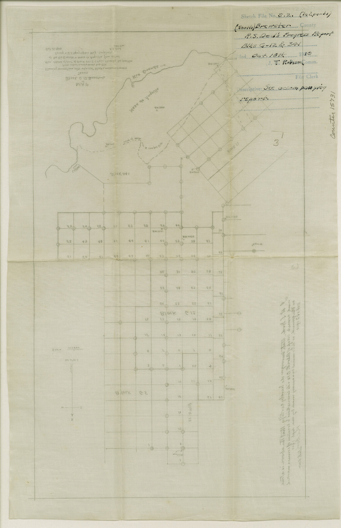
Brewster County Sketch File S-2
[Sketch and report on progress on resurvey of Blocks G-12 and 341]
-
Map/Doc
15731
-
Collection
General Map Collection
-
Object Dates
1910 (Creation Date)
1910/10/18 (File Date)
-
People and Organizations
R.S. Dod (Surveyor/Engineer)
-
Counties
Brewster
-
Subjects
Surveying Sketch File
-
Height x Width
17.0 x 11.0 inches
43.2 x 27.9 cm
-
Medium
multi-page, multi-format
-
Features
Aqua Fria Spring
Cigar Springs
Rio Grande
Lajitas
Mariposa Mine
Grand Canyon
Part of: General Map Collection
Mills County Working Sketch 14

Print $20.00
- Digital $50.00
Mills County Working Sketch 14
1946
Size 27.5 x 28.1 inches
Map/Doc 71044
Flight Mission No. BRA-7M, Frame 151, Jefferson County

Print $20.00
- Digital $50.00
Flight Mission No. BRA-7M, Frame 151, Jefferson County
1953
Size 18.7 x 22.6 inches
Map/Doc 85545
Live Oak County

Print $40.00
- Digital $50.00
Live Oak County
1899
Size 50.3 x 35.3 inches
Map/Doc 16882
[Surveys along the Leon River and Plum Creek]
![69730, [Surveys along the Leon River and Plum Creek], General Map Collection](https://historictexasmaps.com/wmedia_w700/maps/69730.tif.jpg)
Print $2.00
- Digital $50.00
[Surveys along the Leon River and Plum Creek]
1846
Size 9.0 x 14.0 inches
Map/Doc 69730
Reeves County Working Sketch 32

Print $40.00
- Digital $50.00
Reeves County Working Sketch 32
1969
Size 58.3 x 37.9 inches
Map/Doc 63475
Montgomery County Sketch File 15

Print $4.00
- Digital $50.00
Montgomery County Sketch File 15
1906
Size 9.4 x 8.5 inches
Map/Doc 31817
Flight Mission No. CLL-1N, Frame 88, Willacy County

Print $20.00
- Digital $50.00
Flight Mission No. CLL-1N, Frame 88, Willacy County
1954
Size 18.4 x 22.1 inches
Map/Doc 87034
Wharton County Working Sketch 8

Print $20.00
- Digital $50.00
Wharton County Working Sketch 8
1983
Size 37.2 x 32.3 inches
Map/Doc 72472
Brazoria County Working Sketch 33

Print $20.00
- Digital $50.00
Brazoria County Working Sketch 33
1980
Size 29.6 x 35.6 inches
Map/Doc 67518
Coast Chart No. 210 Aransas Pass and Corpus Christi Bay with the coast to latitude 27° 12' Texas

Print $20.00
- Digital $50.00
Coast Chart No. 210 Aransas Pass and Corpus Christi Bay with the coast to latitude 27° 12' Texas
1887
Size 27.1 x 18.3 inches
Map/Doc 72804
Cass County Working Sketch 45

Print $20.00
- Digital $50.00
Cass County Working Sketch 45
1989
Size 21.3 x 30.1 inches
Map/Doc 67948
Webb County Sketch File 5a

Print $8.00
- Digital $50.00
Webb County Sketch File 5a
1877
Size 12.9 x 8.2 inches
Map/Doc 39729
You may also like
[J. Poitevent Blocks 1 and 2, T. & P. Blocks 31-36, Townships 3N-5N and other Blocks in vicinity]
![93195, [J. Poitevent Blocks 1 and 2, T. & P. Blocks 31-36, Townships 3N-5N and other Blocks in vicinity], Twichell Survey Records](https://historictexasmaps.com/wmedia_w700/maps/93195-1.tif.jpg)
Print $40.00
- Digital $50.00
[J. Poitevent Blocks 1 and 2, T. & P. Blocks 31-36, Townships 3N-5N and other Blocks in vicinity]
Size 50.0 x 50.1 inches
Map/Doc 93195
Culberson Co.

Print $40.00
- Digital $50.00
Culberson Co.
1943
Size 53.1 x 33.1 inches
Map/Doc 95473
Kimble County Working Sketch 66

Print $20.00
- Digital $50.00
Kimble County Working Sketch 66
1965
Size 31.1 x 27.2 inches
Map/Doc 70134
Cooke County Sketch File 20

Print $22.00
- Digital $50.00
Cooke County Sketch File 20
1862
Size 9.1 x 6.9 inches
Map/Doc 19264
[Gulf, Colorado & Santa Fe Railway line through Fort Bend Co.]
![64212, [Gulf, Colorado & Santa Fe Railway line through Fort Bend Co.], General Map Collection](https://historictexasmaps.com/wmedia_w700/maps/64212.tif.jpg)
Print $20.00
- Digital $50.00
[Gulf, Colorado & Santa Fe Railway line through Fort Bend Co.]
1898
Size 14.2 x 33.5 inches
Map/Doc 64212
Falls County Working Sketch 1

Print $20.00
- Digital $50.00
Falls County Working Sketch 1
1922
Size 23.0 x 33.1 inches
Map/Doc 69176
Deaf Smith County Sketch File C

Print $28.00
- Digital $50.00
Deaf Smith County Sketch File C
1902
Size 11.5 x 8.9 inches
Map/Doc 20639
Grayson County Working Sketch 14

Print $20.00
- Digital $50.00
Grayson County Working Sketch 14
1952
Size 23.9 x 23.3 inches
Map/Doc 63253
Nueces County Sketch File 14

Print $20.00
- Digital $50.00
Nueces County Sketch File 14
Size 18.3 x 20.8 inches
Map/Doc 42179
Guadalupe County Sketch File 7a

Print $4.00
- Digital $50.00
Guadalupe County Sketch File 7a
1873
Size 10.2 x 8.2 inches
Map/Doc 24668
Schleicher County Sketch File 21

Print $40.00
- Digital $50.00
Schleicher County Sketch File 21
1936
Size 14.5 x 15.2 inches
Map/Doc 36510
Cottle County Sketch File G

Print $8.00
- Digital $50.00
Cottle County Sketch File G
Size 11.5 x 7.3 inches
Map/Doc 19447