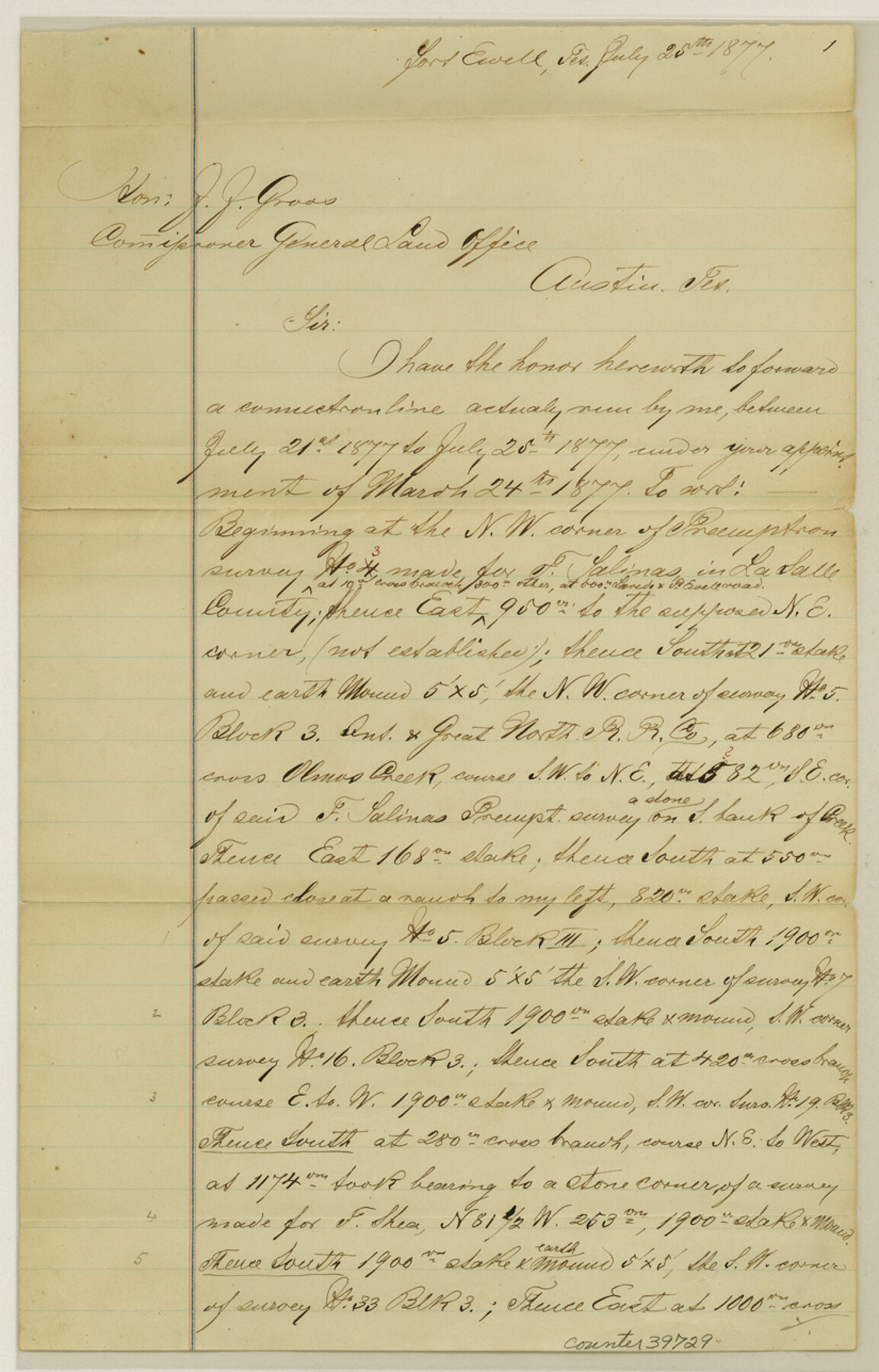
Webb County Sketch File 5a
[Connecting line between I. & G. N. R.R. Co. surveys and Nido waterhole]
-
Map/Doc
39729
-
Collection
General Map Collection
-
Object Dates
7/25/1877 (Creation Date)
8/1/1877 (File Date)
-
People and Organizations
A. Wyschetzki (Surveyor/Engineer)
-
Counties
Webb
-
Subjects
Surveying Sketch File
-
Height x Width
12.9 x 8.2 inches
32.8 x 20.8 cm
-
Medium
paper, manuscript
-
Features
Road from Fort Ewell to Laredo
Olmos Creek
Part of: General Map Collection
Montgomery County Working Sketch 67

Print $20.00
- Digital $50.00
Montgomery County Working Sketch 67
1972
Size 35.0 x 29.6 inches
Map/Doc 71174
Reeves County Working Sketch 2

Print $20.00
- Digital $50.00
Reeves County Working Sketch 2
1903
Size 22.6 x 42.4 inches
Map/Doc 63444
Van Zandt County Working Sketch 2

Print $20.00
- Digital $50.00
Van Zandt County Working Sketch 2
1910
Size 17.8 x 11.6 inches
Map/Doc 72251
Flight Mission No. CGI-3N, Frame 123, Cameron County

Print $20.00
- Digital $50.00
Flight Mission No. CGI-3N, Frame 123, Cameron County
1954
Size 18.6 x 22.2 inches
Map/Doc 84596
Andrews County Rolled Sketch 9

Print $20.00
- Digital $50.00
Andrews County Rolled Sketch 9
1930
Size 25.3 x 43.6 inches
Map/Doc 77160
Kleberg County Rolled Sketch 10-40

Print $20.00
- Digital $50.00
Kleberg County Rolled Sketch 10-40
1952
Size 38.1 x 34.0 inches
Map/Doc 9392
Wilbarger County Boundary File 1b

Print $40.00
- Digital $50.00
Wilbarger County Boundary File 1b
Size 14.3 x 8.8 inches
Map/Doc 59943
Presidio County Rolled Sketch 131A

Print $20.00
- Digital $50.00
Presidio County Rolled Sketch 131A
1992
Size 36.5 x 46.7 inches
Map/Doc 9802
Edwards County Working Sketch 3

Print $20.00
- Digital $50.00
Edwards County Working Sketch 3
Size 22.6 x 18.3 inches
Map/Doc 68879
McLennan County Sketch File 1

Print $4.00
- Digital $50.00
McLennan County Sketch File 1
Size 11.5 x 8.4 inches
Map/Doc 31224
Cameron County Rolled Sketch 33

Print $20.00
- Digital $50.00
Cameron County Rolled Sketch 33
1996
Size 40.2 x 21.9 inches
Map/Doc 5396
Kimble County Sketch File 1

Print $4.00
- Digital $50.00
Kimble County Sketch File 1
1854
Size 7.2 x 10.0 inches
Map/Doc 28907
You may also like
The Chief Justice County of Red River. Lands in Conflict with Nacogdoches County

Print $20.00
The Chief Justice County of Red River. Lands in Conflict with Nacogdoches County
2020
Size 17.4 x 21.8 inches
Map/Doc 96066
[Surveys along the Neches River in Jasper District]
![69733, [Surveys along the Neches River in Jasper District], General Map Collection](https://historictexasmaps.com/wmedia_w700/maps/69733.tif.jpg)
Print $2.00
- Digital $50.00
[Surveys along the Neches River in Jasper District]
1847
Size 9.2 x 6.8 inches
Map/Doc 69733
Flight Mission No. DCL-6C, Frame 76, Kenedy County

Print $20.00
- Digital $50.00
Flight Mission No. DCL-6C, Frame 76, Kenedy County
1943
Size 18.6 x 22.3 inches
Map/Doc 85918
Jeff Davis County Working Sketch 36

Print $20.00
- Digital $50.00
Jeff Davis County Working Sketch 36
1979
Size 37.2 x 28.8 inches
Map/Doc 66531
Parker County Working Sketch 21

Print $20.00
- Digital $50.00
Parker County Working Sketch 21
2006
Map/Doc 83655
Reeves County Rolled Sketch 33

Print $20.00
- Digital $50.00
Reeves County Rolled Sketch 33
Size 24.6 x 36.9 inches
Map/Doc 7504
Houston including Bellaire, Bunker Hill, Galena Park, Hedwig, Hilshire, Hunters Creek, Jacinto City, Jersey Village, Missouri City, Pasadena, Piney Point, South Houston, Spring Valley, West University Place and adjoining communities [Verso]
![94180, Houston including Bellaire, Bunker Hill, Galena Park, Hedwig, Hilshire, Hunters Creek, Jacinto City, Jersey Village, Missouri City, Pasadena, Piney Point, South Houston, Spring Valley, West University Place and adjoining communities [Verso], General Map Collection](https://historictexasmaps.com/wmedia_w700/maps/94180.tif.jpg)
Houston including Bellaire, Bunker Hill, Galena Park, Hedwig, Hilshire, Hunters Creek, Jacinto City, Jersey Village, Missouri City, Pasadena, Piney Point, South Houston, Spring Valley, West University Place and adjoining communities [Verso]
Size 27.1 x 42.4 inches
Map/Doc 94180
Montague County Working Sketch 41

Print $40.00
- Digital $50.00
Montague County Working Sketch 41
1923
Size 43.3 x 70.1 inches
Map/Doc 65350
Calhoun County Rolled Sketch 30

Print $20.00
- Digital $50.00
Calhoun County Rolled Sketch 30
1974
Size 18.6 x 27.6 inches
Map/Doc 5495
Map of Block 1, H. & G. N. R. R. Co., Dickens and Kent Counties Texas

Print $20.00
- Digital $50.00
Map of Block 1, H. & G. N. R. R. Co., Dickens and Kent Counties Texas
1908
Size 32.0 x 24.2 inches
Map/Doc 10780
Map of the Survey of the Parallel 36 1/2 Degrees North Latitude, Commencing at the 100th and Running to the 103rd Degree of Longitude West of Greenwich

Print $40.00
- Digital $50.00
Map of the Survey of the Parallel 36 1/2 Degrees North Latitude, Commencing at the 100th and Running to the 103rd Degree of Longitude West of Greenwich
1862
Size 87.1 x 11.1 inches
Map/Doc 3084
Pecos County Rolled Sketch 108

Print $20.00
- Digital $50.00
Pecos County Rolled Sketch 108
1940
Size 39.7 x 30.7 inches
Map/Doc 7254