Kleberg County Rolled Sketch 10-40
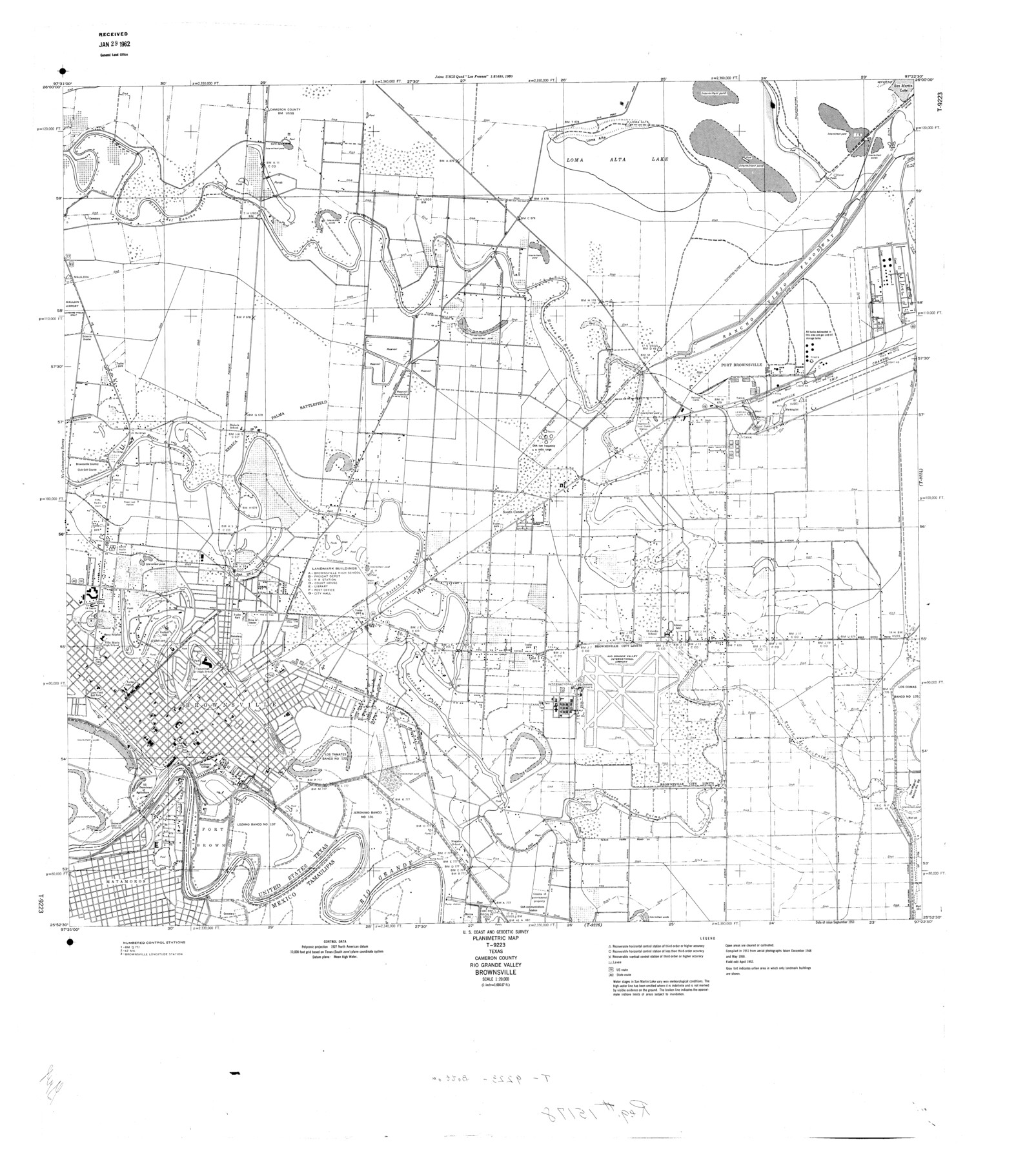
Planimetric Map T-9223, Texas, Cameron County, Rio Grande Valley, Brownsville
-
Map/Doc
9392
-
Collection
General Map Collection
-
Object Dates
1952 (Creation Date)
1962/1/29 (File Date)
-
People and Organizations
U.S. Coast and Geodetic Survey (Publisher)
-
Counties
Cameron
-
Subjects
Surveying Rolled Sketch
-
Height x Width
38.1 x 34.0 inches
96.8 x 86.4 cm
-
Scale
1" = 1666.67 feet
Part of: General Map Collection
Callahan County Working Sketch Graphic Index

Print $20.00
- Digital $50.00
Callahan County Working Sketch Graphic Index
1969
Size 41.3 x 33.4 inches
Map/Doc 76485
Calhoun County Rolled Sketch 14

Print $20.00
- Digital $50.00
Calhoun County Rolled Sketch 14
Size 22.3 x 40.8 inches
Map/Doc 5456
Map of Collin County

Print $20.00
- Digital $50.00
Map of Collin County
1850
Size 18.1 x 22.5 inches
Map/Doc 4519
Dallas County Sketch File 11

Print $12.00
- Digital $50.00
Dallas County Sketch File 11
1860
Size 8.5 x 7.9 inches
Map/Doc 20416
Wood County Working Sketch 10

Print $20.00
- Digital $50.00
Wood County Working Sketch 10
1943
Size 29.6 x 30.4 inches
Map/Doc 62010
Houston County Sketch File 33

Print $20.00
- Digital $50.00
Houston County Sketch File 33
1894
Size 16.9 x 18.4 inches
Map/Doc 11790
Smith County Rolled Sketch 3

Print $40.00
- Digital $50.00
Smith County Rolled Sketch 3
Size 55.2 x 42.8 inches
Map/Doc 9934
Terrell County Working Sketch 57

Print $20.00
- Digital $50.00
Terrell County Working Sketch 57
1959
Size 30.0 x 25.8 inches
Map/Doc 69578
Haskell County

Print $20.00
- Digital $50.00
Haskell County
1888
Size 38.5 x 37.1 inches
Map/Doc 4700
Kinney County Sketch File 23

Print $40.00
- Digital $50.00
Kinney County Sketch File 23
1901
Size 17.6 x 15.3 inches
Map/Doc 29162
Glasscock County Working Sketch 10

Print $40.00
- Digital $50.00
Glasscock County Working Sketch 10
1957
Size 77.9 x 37.2 inches
Map/Doc 63183
Wichita County Working Sketch 13

Print $20.00
- Digital $50.00
Wichita County Working Sketch 13
1921
Size 16.5 x 32.8 inches
Map/Doc 72523
You may also like
Kerr County Rolled Sketch 20

Print $20.00
- Digital $50.00
Kerr County Rolled Sketch 20
1955
Size 30.2 x 35.2 inches
Map/Doc 6502
Florida et Apalche

Print $20.00
- Digital $50.00
Florida et Apalche
1597
Size 11.2 x 14.4 inches
Map/Doc 94076
Military Reconstruction Districts

Military Reconstruction Districts
2024
Size 8.5 x 11.0 inches
Map/Doc 97345
San Antonio & Aransas Pass

Print $40.00
- Digital $50.00
San Antonio & Aransas Pass
Size 30.9 x 74.5 inches
Map/Doc 64633
Sabine Pass and Lake

Print $20.00
- Digital $50.00
Sabine Pass and Lake
1961
Size 46.7 x 28.1 inches
Map/Doc 69824
Zavala County Working Sketch 14

Print $20.00
- Digital $50.00
Zavala County Working Sketch 14
1976
Size 20.0 x 12.9 inches
Map/Doc 62089
Wichita County Sketch File 14

Print $20.00
- Digital $50.00
Wichita County Sketch File 14
1885
Size 17.7 x 17.0 inches
Map/Doc 12678
Bandera County Working Sketch 24

Print $20.00
- Digital $50.00
Bandera County Working Sketch 24
1950
Size 31.6 x 33.0 inches
Map/Doc 67620
Kinney County Working Sketch 1

Print $20.00
- Digital $50.00
Kinney County Working Sketch 1
Size 22.6 x 24.0 inches
Map/Doc 70183
New City Map of Laredo, Texas

Print $20.00
New City Map of Laredo, Texas
1930
Size 21.7 x 11.3 inches
Map/Doc 76277
Flight Mission No. BRA-16M, Frame 54, Jefferson County

Print $20.00
- Digital $50.00
Flight Mission No. BRA-16M, Frame 54, Jefferson County
1953
Size 18.5 x 22.5 inches
Map/Doc 85671
La Salle County Sketch File 34

Print $6.00
- Digital $50.00
La Salle County Sketch File 34
Size 15.8 x 9.5 inches
Map/Doc 29585