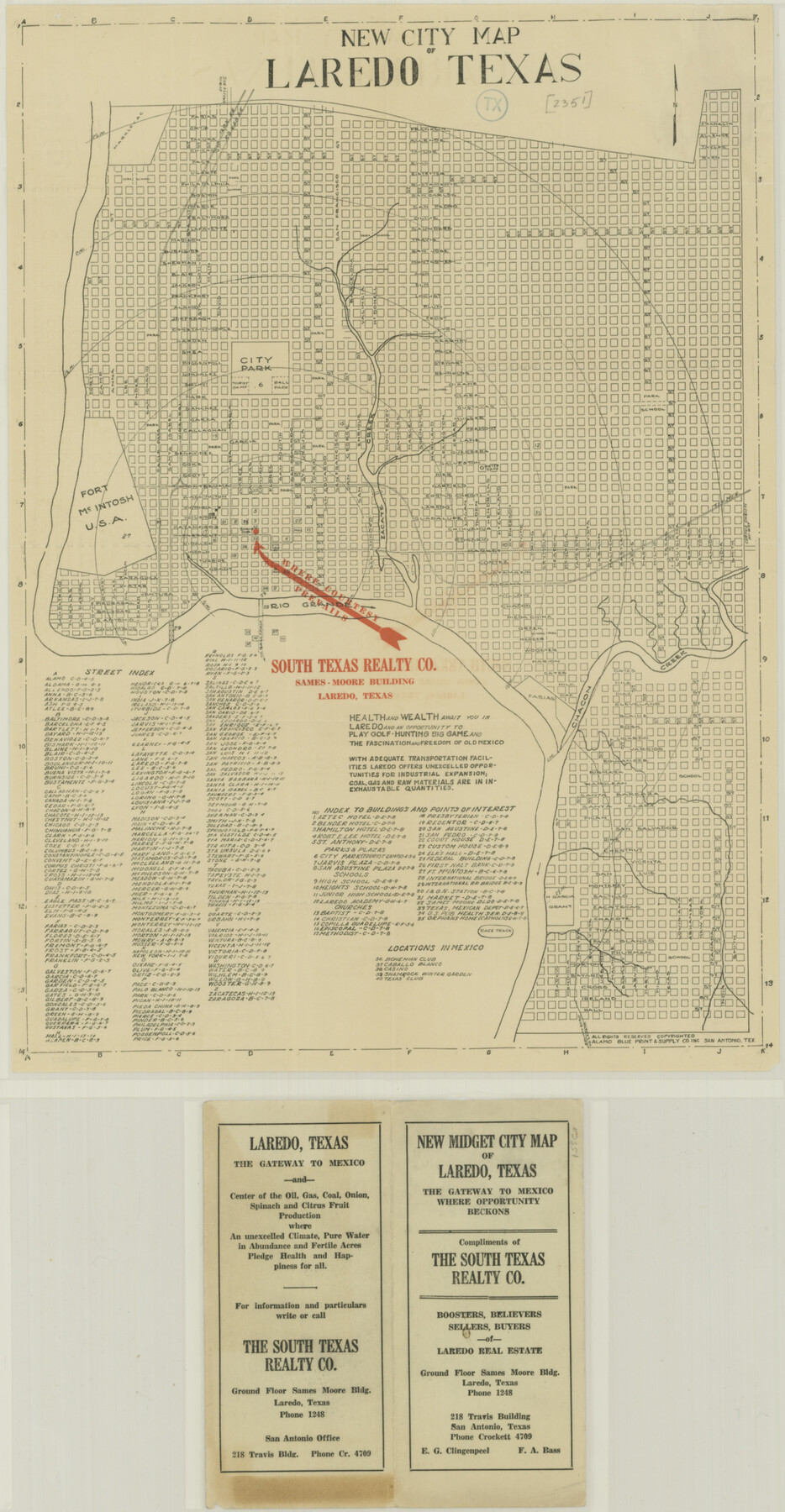
New City Map of Laredo, Texas
-
Map/Doc
76277
-
Collection
Texas State Library and Archives
-
Object Dates
1930 (Creation Date)
-
People and Organizations
Alamo Blue Print and Supply Company, Inc. (Publisher)
-
Counties
Webb
-
Subjects
City
-
Height x Width
21.7 x 11.3 inches
55.1 x 28.7 cm
-
Comments
Prints available courtesy of the Texas State Library and Archives.
More info can be found here: TSLAC Map 02351
Part of: Texas State Library and Archives
General Highway Map, Matagorda County, Texas

Print $20.00
General Highway Map, Matagorda County, Texas
1939
Size 24.7 x 18.3 inches
Map/Doc 79187
General Highway Map, Smith County, Texas

Print $20.00
General Highway Map, Smith County, Texas
1939
Size 24.9 x 18.4 inches
Map/Doc 79244
Military Reconnaissance of the Arkansas, Rio Del Norte, and Rio Gila

Print $40.00
Military Reconnaissance of the Arkansas, Rio Del Norte, and Rio Gila
1847
Size 33.3 x 72.6 inches
Map/Doc 76240
General Highway Map, Nolan County, Texas

Print $20.00
General Highway Map, Nolan County, Texas
1940
Size 18.4 x 24.7 inches
Map/Doc 79208
Military Map of Southwestern Texas

Print $20.00
Military Map of Southwestern Texas
1881
Size 24.3 x 38.4 inches
Map/Doc 76316
General Highway Map, Brazos County, Texas

Print $20.00
General Highway Map, Brazos County, Texas
1961
Size 24.9 x 18.3 inches
Map/Doc 79384
General Highway Map, Newton County, Texas

Print $20.00
General Highway Map, Newton County, Texas
1961
Size 19.3 x 25.0 inches
Map/Doc 79613
Preliminary Sketch of Galveston Bay Indicating Proposed Sites for Light Houses

Print $20.00
Preliminary Sketch of Galveston Bay Indicating Proposed Sites for Light Houses
1851
Size 20.7 x 18.0 inches
Map/Doc 76215
General Highway Map, Armstrong County, Texas

Print $20.00
General Highway Map, Armstrong County, Texas
1961
Size 18.3 x 25.0 inches
Map/Doc 79354
General Highway Map, Ellis County, Texas

Print $20.00
General Highway Map, Ellis County, Texas
1961
Size 18.2 x 24.6 inches
Map/Doc 79453
General Highway Map, Madison County, Texas

Print $20.00
General Highway Map, Madison County, Texas
1961
Size 18.1 x 24.6 inches
Map/Doc 79581
General Highway Map, Anderson County, Texas

Print $20.00
General Highway Map, Anderson County, Texas
1936
Size 18.4 x 24.9 inches
Map/Doc 79001
You may also like
Van Zandt County

Print $20.00
- Digital $50.00
Van Zandt County
1857
Size 20.0 x 25.3 inches
Map/Doc 8144
Hall County Sketch File 29 and 29a

Print $12.00
- Digital $50.00
Hall County Sketch File 29 and 29a
1913
Size 8.9 x 7.9 inches
Map/Doc 24824
Sketch of 103rd Meridian, W. L. Showing Conflict of Capitol Leagues

Print $40.00
- Digital $50.00
Sketch of 103rd Meridian, W. L. Showing Conflict of Capitol Leagues
Size 26.9 x 85.1 inches
Map/Doc 65505
Flight Mission No. DQO-11K, Frame 15, Galveston County

Print $20.00
- Digital $50.00
Flight Mission No. DQO-11K, Frame 15, Galveston County
1952
Size 18.7 x 22.3 inches
Map/Doc 85208
[Surveys in Waller County]
![78367, [Surveys in Waller County], General Map Collection](https://historictexasmaps.com/wmedia_w700/maps/78367.tif.jpg)
Print $20.00
- Digital $50.00
[Surveys in Waller County]
Size 21.5 x 28.7 inches
Map/Doc 78367
Tom Green County Rolled Sketch 5

Print $20.00
- Digital $50.00
Tom Green County Rolled Sketch 5
1947
Size 44.9 x 35.0 inches
Map/Doc 9997
General Highway Map, Kimble County, Texas

Print $20.00
General Highway Map, Kimble County, Texas
1940
Size 24.9 x 18.3 inches
Map/Doc 79159
Andrews County Working Sketch 10

Print $20.00
- Digital $50.00
Andrews County Working Sketch 10
1955
Size 30.5 x 43.7 inches
Map/Doc 67056
Presidio County Working Sketch 126

Print $20.00
- Digital $50.00
Presidio County Working Sketch 126
1987
Size 36.9 x 46.5 inches
Map/Doc 71804
The Republic County of Harris. January 21, 1841

Print $20.00
The Republic County of Harris. January 21, 1841
2020
Size 17.7 x 21.7 inches
Map/Doc 96166
Souvenir - Opening and Dedication of the General Oil Company's New West Texas Oil Field

Souvenir - Opening and Dedication of the General Oil Company's New West Texas Oil Field
1920
Map/Doc 97263
Gaines County Rolled Sketch 16

Print $40.00
- Digital $50.00
Gaines County Rolled Sketch 16
1940
Size 51.2 x 36.0 inches
Map/Doc 9039