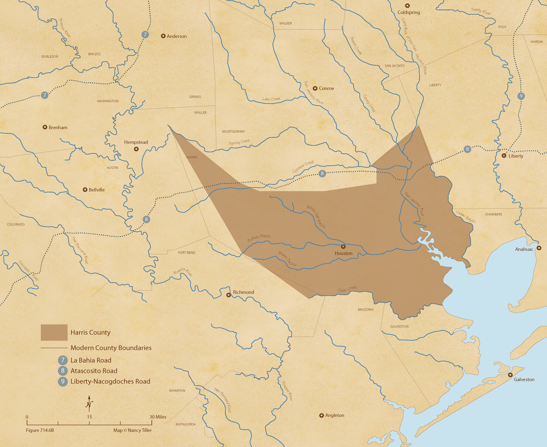
The Republic County of Harris. January 21, 1841
Figure No. 714.6 from 'A Boundary Atlas of Texas, 1821-1845' by Jim Tiller
-
Map/Doc
96166
-
Collection
Nancy and Jim Tiller Digital Collection
-
Object Dates
2020/1/1 (Creation Date)
-
People and Organizations
Jim Tiller (Author)
Nancy Tiller (Cartographer)
Gang Gong (GIS Professional)
-
Counties
Harris
-
Subjects
Atlas County Republic of Texas Texas Boundaries
-
Height x Width
17.7 x 21.7 inches
45.0 x 55.1 cm
-
Medium
digital image
-
Comments
To purchase a digital PDF copy of "A Boundary Atlas of Texas, 1821-1845" see 96437.
Part of: Nancy and Jim Tiller Digital Collection
The Chief Justice County of Jasper. Lands in Conflict with Sabine County

Print $20.00
The Chief Justice County of Jasper. Lands in Conflict with Sabine County
2020
Size 18.3 x 21.7 inches
Map/Doc 96053
The Republic County of Harris. Spring 1842

Print $20.00
The Republic County of Harris. Spring 1842
2020
Size 17.7 x 21.7 inches
Map/Doc 96167
The Republic County of Lamar. January 3, 1844

Print $20.00
The Republic County of Lamar. January 3, 1844
2020
Size 16.4 x 21.7 inches
Map/Doc 96206
The Republic County of Shelby. February 1, 1845

Print $20.00
The Republic County of Shelby. February 1, 1845
2020
Size 20.0 x 21.7 inches
Map/Doc 96287
The Chief Justice County of Colorado. Undated

Print $20.00
The Chief Justice County of Colorado. Undated
2020
Size 14.8 x 21.6 inches
Map/Doc 96044
The Republic County of Matagorda. Spring 1842

Print $20.00
The Republic County of Matagorda. Spring 1842
2020
Size 21.0 x 21.7 inches
Map/Doc 96222
The Chief Justice County of Colorado. Lands in Conflict with Brazoria, Mina Counties

Print $20.00
The Chief Justice County of Colorado. Lands in Conflict with Brazoria, Mina Counties
2020
Size 14.8 x 21.7 inches
Map/Doc 96045
The Republic County of Montgomery. Spring 1842

Print $20.00
The Republic County of Montgomery. Spring 1842
2020
Size 19.9 x 21.7 inches
Map/Doc 96240
The Republic County of Jackson. Boundaries Defined, December 29, 1837

Print $20.00
The Republic County of Jackson. Boundaries Defined, December 29, 1837
2020
Size 15.6 x 21.8 inches
Map/Doc 96184
The Mexican Municipality of Jackson. Created, December 5, 1835

Print $20.00
The Mexican Municipality of Jackson. Created, December 5, 1835
2020
Size 17.7 x 21.7 inches
Map/Doc 96023
The Judicial District/County of Pashcal. Abolished, Spring 1842

Print $20.00
The Judicial District/County of Pashcal. Abolished, Spring 1842
2020
Size 15.0 x 21.7 inches
Map/Doc 96345
The Republic County of Brazoria. Proposed, Late Fall 1837-January 1, 1838

Print $20.00
The Republic County of Brazoria. Proposed, Late Fall 1837-January 1, 1838
2020
Size 13.0 x 21.7 inches
Map/Doc 96110
You may also like
Schleicher County Sketch File 16

Print $6.00
- Digital $50.00
Schleicher County Sketch File 16
Size 11.6 x 15.4 inches
Map/Doc 36506
Hutchinson County Rolled Sketch 37A

Print $40.00
- Digital $50.00
Hutchinson County Rolled Sketch 37A
1950
Size 24.7 x 50.5 inches
Map/Doc 9246
San Patricio County Sketch File 9

Print $2.00
- Digital $50.00
San Patricio County Sketch File 9
1846
Size 8.3 x 8.7 inches
Map/Doc 36039
Cooke County Working Sketch 31

Print $20.00
- Digital $50.00
Cooke County Working Sketch 31
1980
Size 27.0 x 32.2 inches
Map/Doc 68268
McMullen County Sketch File 16a

Print $40.00
- Digital $50.00
McMullen County Sketch File 16a
Size 12.5 x 12.5 inches
Map/Doc 31367
Brewster County Sketch File N-6

Print $40.00
- Digital $50.00
Brewster County Sketch File N-6
1914
Size 15.8 x 12.7 inches
Map/Doc 10963
Orange County Sketch File B1

Print $22.00
- Digital $50.00
Orange County Sketch File B1
Size 14.3 x 8.9 inches
Map/Doc 33288
[Surveying Sketch of M. Farley, R. Word, S. S. Hervey, et al in Kleberg County, Texas]
![10783, [Surveying Sketch of M. Farley, R. Word, S. S. Hervey, et al in Kleberg County, Texas], Maddox Collection](https://historictexasmaps.com/wmedia_w700/maps/10783.tif.jpg)
Print $20.00
- Digital $50.00
[Surveying Sketch of M. Farley, R. Word, S. S. Hervey, et al in Kleberg County, Texas]
Size 23.2 x 40.6 inches
Map/Doc 10783
Map of Harris County

Print $20.00
- Digital $50.00
Map of Harris County
1893
Size 26.6 x 34.4 inches
Map/Doc 65810
Parker County Sketch File 37

Print $4.00
- Digital $50.00
Parker County Sketch File 37
Size 4.8 x 8.1 inches
Map/Doc 33581
Gray County Working Sketch 2

Print $20.00
- Digital $50.00
Gray County Working Sketch 2
1957
Size 26.7 x 27.8 inches
Map/Doc 63233
Capitol Syndicate Subdivision of Capitol Land Reservation Leagues Number 153, 154, 155, 156, 157, 158, 167, 168, 169, 170, 171, and 172 and Parts of Leagues 143, 144, 145, 146, 152, 159, 166, and 173

Print $20.00
- Digital $50.00
Capitol Syndicate Subdivision of Capitol Land Reservation Leagues Number 153, 154, 155, 156, 157, 158, 167, 168, 169, 170, 171, and 172 and Parts of Leagues 143, 144, 145, 146, 152, 159, 166, and 173
1908
Size 22.8 x 34.6 inches
Map/Doc 90735