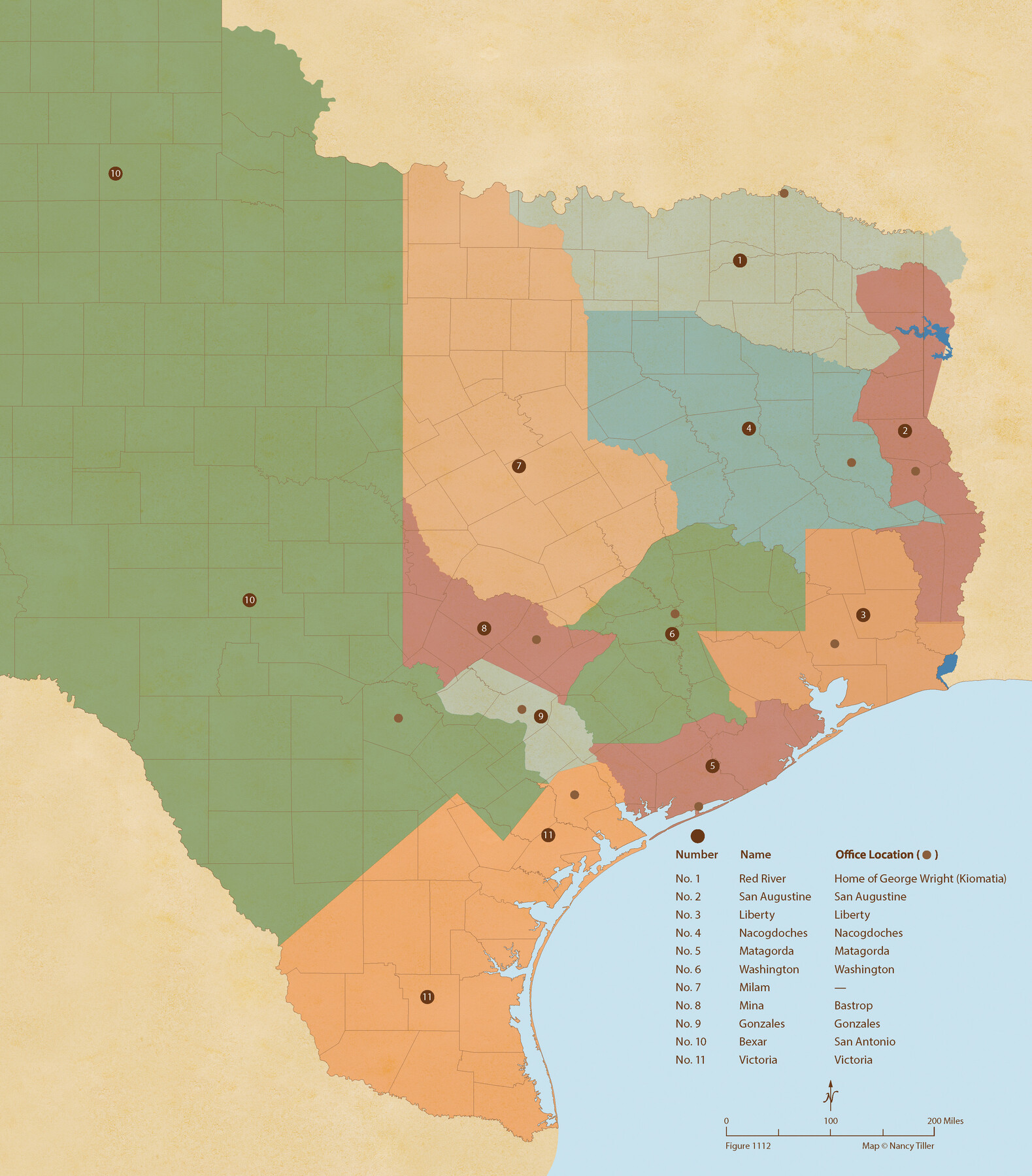
The Land Offices. December 22, 1836
Figure No. 1112 from 'A Boundary Atlas of Texas, 1821-1845' by Jim Tiller
-
Map/Doc
96425
-
Collection
Nancy and Jim Tiller Digital Collection
-
Object Dates
2020/1/1 (Creation Date)
-
People and Organizations
Jim Tiller (Author)
Nancy Tiller (Cartographer)
Gang Gong (GIS Professional)
-
Subjects
Atlas Republic of Texas Texas Boundaries
-
Height x Width
24.7 x 21.7 inches
62.7 x 55.1 cm
-
Medium
digital image
-
Comments
To purchase a digital PDF copy of "A Boundary Atlas of Texas, 1821-1845" see 96437.
Part of: Nancy and Jim Tiller Digital Collection
The Judicial District/County of Panola. Abolished, Spring 1842

Print $20.00
The Judicial District/County of Panola. Abolished, Spring 1842
2020
Size 19.3 x 21.7 inches
Map/Doc 96342
Text and Map Related to the Creation of a New County Out of Red River and Shelby Counties (Unnamed), Undated

Print $20.00
Text and Map Related to the Creation of a New County Out of Red River and Shelby Counties (Unnamed), Undated
2020
Size 12.5 x 19.7 inches
Map/Doc 96403
The Judicial District/County of Burnet. Boundaries Redefined, December 6, 1841

Print $20.00
The Judicial District/County of Burnet. Boundaries Redefined, December 6, 1841
2020
Size 19.2 x 21.6 inches
Map/Doc 96323
The Republic County of Austin. Proposed, Fall 1837-May 23, 1838

Print $20.00
The Republic County of Austin. Proposed, Fall 1837-May 23, 1838
2020
Size 14.8 x 21.7 inches
Map/Doc 96081
The Chief Justice County of Harrisburg. January 30, 1837

Print $20.00
The Chief Justice County of Harrisburg. January 30, 1837
2020
Size 17.5 x 21.7 inches
Map/Doc 96049
The Republic County of Matagorda. Refined, January 25, 1841

Print $20.00
The Republic County of Matagorda. Refined, January 25, 1841
2020
Size 19.3 x 21.8 inches
Map/Doc 96221
Republic Counties. January 1, 1840

Print $20.00
Republic Counties. January 1, 1840
2020
Size 24.5 x 21.7 inches
Map/Doc 96313
The Mexican Municipality of Jackson. Created, December 5, 1835

Print $20.00
The Mexican Municipality of Jackson. Created, December 5, 1835
2020
Size 17.7 x 21.7 inches
Map/Doc 96023
The Chief Justice County of Liberty. Lands in Conflict with Harrisburg County

Print $20.00
The Chief Justice County of Liberty. Lands in Conflict with Harrisburg County
2020
Size 20.5 x 21.7 inches
Map/Doc 96056
The Land Offices. No. 2, San Augustine, December 22, 1836

Print $20.00
The Land Offices. No. 2, San Augustine, December 22, 1836
2020
Size 19.7 x 18.4 inches
Map/Doc 96415
McMullen and McGloin Empresario Colony. August 16, 1828

Print $20.00
McMullen and McGloin Empresario Colony. August 16, 1828
2020
Size 17.6 x 21.7 inches
Map/Doc 95998
The Republic County of Goliad. December 29, 1845

Print $20.00
The Republic County of Goliad. December 29, 1845
2020
Size 17.5 x 21.7 inches
Map/Doc 96152
You may also like
Refugio County Working Sketch 3

Print $20.00
- Digital $50.00
Refugio County Working Sketch 3
1927
Size 21.9 x 24.6 inches
Map/Doc 63512
Flight Mission No. CGI-3N, Frame 145, Cameron County

Print $20.00
- Digital $50.00
Flight Mission No. CGI-3N, Frame 145, Cameron County
1954
Size 18.6 x 22.3 inches
Map/Doc 84618
El Paso County Rolled Sketch 51

Print $40.00
- Digital $50.00
El Paso County Rolled Sketch 51
Size 42.9 x 75.3 inches
Map/Doc 8877
Map of Wyoming Showing Test Wells for Oil and Gas, Anticlinal Axes, Oil and Gas Fields, Pipeline, Unit Areas and Land District Boundaries

Print $40.00
- Digital $50.00
Map of Wyoming Showing Test Wells for Oil and Gas, Anticlinal Axes, Oil and Gas Fields, Pipeline, Unit Areas and Land District Boundaries
1949
Size 55.2 x 42.6 inches
Map/Doc 89886
Limestone County Working Sketch 15

Print $20.00
- Digital $50.00
Limestone County Working Sketch 15
1936
Size 14.7 x 16.3 inches
Map/Doc 70565
Pecos County Sketch File 87

Print $18.00
- Digital $50.00
Pecos County Sketch File 87
1916
Size 13.3 x 8.9 inches
Map/Doc 33975
Map of Bexar County

Print $20.00
- Digital $50.00
Map of Bexar County
1845
Size 47.5 x 41.7 inches
Map/Doc 87235
Travis County Rolled Sketch 43

Print $20.00
- Digital $50.00
Travis County Rolled Sketch 43
1962
Size 27.3 x 22.7 inches
Map/Doc 8041
Karnes County Boundary File 5

Print $32.00
- Digital $50.00
Karnes County Boundary File 5
Size 12.7 x 8.2 inches
Map/Doc 55705
Val Verde County Sketch File Z19

Print $26.00
- Digital $50.00
Val Verde County Sketch File Z19
1912
Size 23.1 x 21.1 inches
Map/Doc 12559
The Republic County of Harris. January 25, 1840

Print $20.00
The Republic County of Harris. January 25, 1840
2020
Size 17.7 x 21.7 inches
Map/Doc 96165
Childress County Rolled Sketch 8

Print $20.00
- Digital $50.00
Childress County Rolled Sketch 8
1889
Size 12.4 x 22.2 inches
Map/Doc 5442