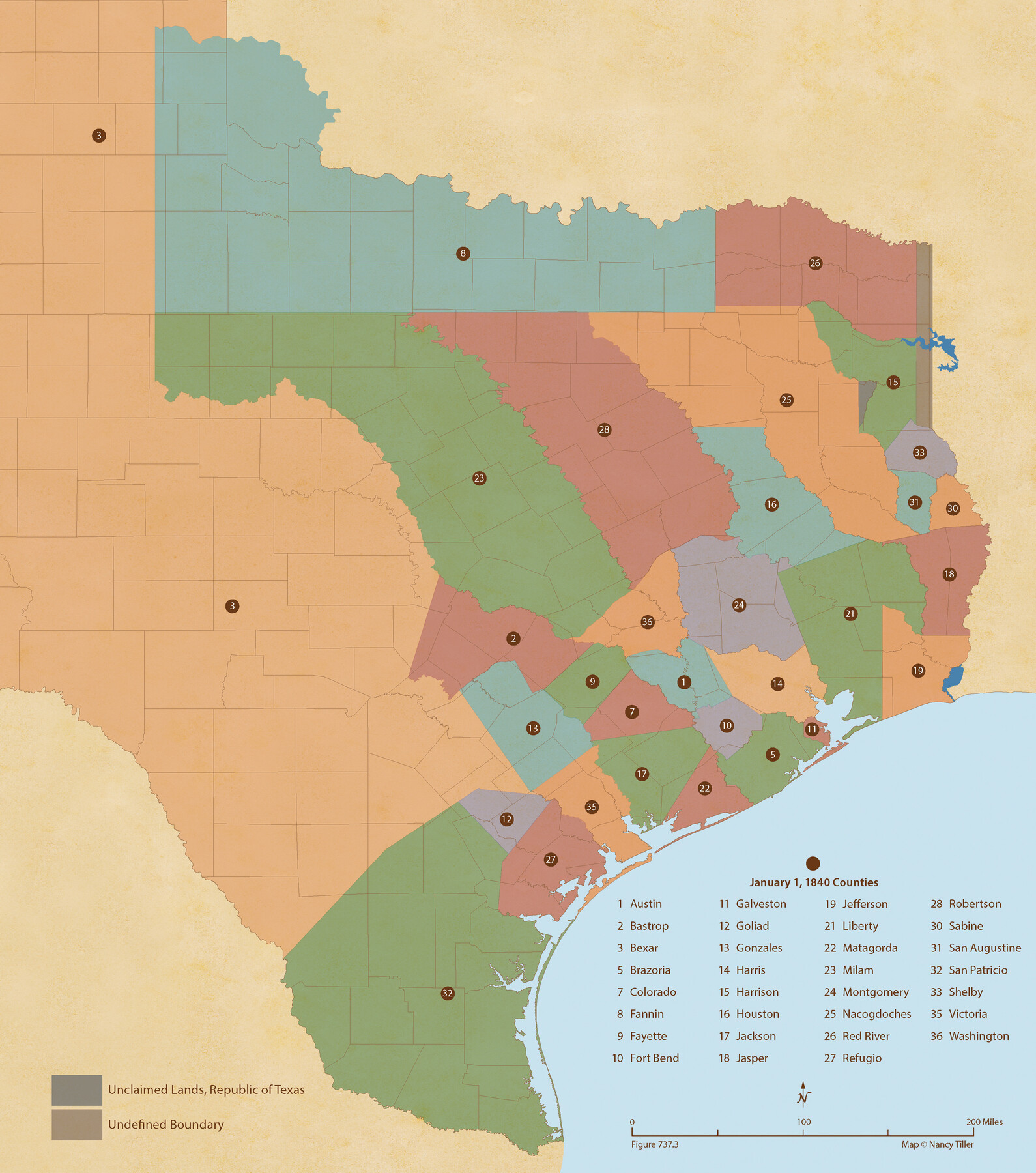
Republic Counties. January 1, 1840
Figure No. 737.3 from 'A Boundary Atlas of Texas, 1821-1845' by Jim Tiller
-
Map/Doc
96313
-
Collection
Nancy and Jim Tiller Digital Collection
-
Object Dates
2020/1/1 (Creation Date)
-
People and Organizations
Jim Tiller (Author)
Nancy Tiller (Cartographer)
Gang Gong (GIS Professional)
-
Subjects
Atlas Republic of Texas Texas Boundaries
-
Height x Width
24.5 x 21.7 inches
62.2 x 55.1 cm
-
Medium
digital image
-
Comments
To purchase a digital PDF copy of "A Boundary Atlas of Texas, 1821-1845" see 96437.
Part of: Nancy and Jim Tiller Digital Collection
Republic Counties. January 1, 1841

Print $20.00
Republic Counties. January 1, 1841
2020
Size 24.5 x 21.7 inches
Map/Doc 96314
The Republic County of Travis. December 29, 1845

Print $20.00
The Republic County of Travis. December 29, 1845
2020
Size 20.8 x 21.6 inches
Map/Doc 96293
The Republic County of Matagorda. January 1, 1838

Print $20.00
The Republic County of Matagorda. January 1, 1838
2020
Size 21.0 x 21.7 inches
Map/Doc 96216
The Judicial District/County of Pashcal. Abolished, Spring 1842

Print $20.00
The Judicial District/County of Pashcal. Abolished, Spring 1842
2020
Size 15.0 x 21.7 inches
Map/Doc 96345
The Republic County of Goliad. December 29, 1845

Print $20.00
The Republic County of Goliad. December 29, 1845
2020
Size 17.5 x 21.7 inches
Map/Doc 96152
The Chief Justice County of Refugio. Proposed, No Date

Print $20.00
The Chief Justice County of Refugio. Proposed, No Date
2020
Size 22.6 x 21.7 inches
Map/Doc 96067
Geographical Observations on the Inner Margins of the Border and Coastal Reserves of Texas, 1824-1836

Geographical Observations on the Inner Margins of the Border and Coastal Reserves of Texas, 1824-1836
2022
Map/Doc 97131
The Republic County of Harrison. June 24, 1841

Print $20.00
The Republic County of Harrison. June 24, 1841
2020
Size 18.6 x 21.7 inches
Map/Doc 96171
The Republic County of Lamar. January 28, 1841

Print $20.00
The Republic County of Lamar. January 28, 1841
2020
Size 16.4 x 21.7 inches
Map/Doc 96203
From Citizens of Nacogdoches County for the Creation of a New County to be Called Smith, September 4, 1841

Print $20.00
From Citizens of Nacogdoches County for the Creation of a New County to be Called Smith, September 4, 1841
2020
Size 18.3 x 21.7 inches
Map/Doc 96392
The Republic County of Colorado. January 19, 1841

Print $20.00
The Republic County of Colorado. January 19, 1841
2020
Size 18.4 x 21.7 inches
Map/Doc 96124
The Republic County of Bexar. December 29, 1845

Print $20.00
The Republic County of Bexar. December 29, 1845
2020
Size 24.6 x 21.6 inches
Map/Doc 96101
You may also like
Hunt County Rolled Sketch 5

Print $20.00
- Digital $50.00
Hunt County Rolled Sketch 5
1956
Size 22.9 x 23.0 inches
Map/Doc 6271
[Sketch for Mineral Application 24072, San Jacinto River]
![65597, [Sketch for Mineral Application 24072, San Jacinto River], General Map Collection](https://historictexasmaps.com/wmedia_w700/maps/65597.tif.jpg)
Print $20.00
- Digital $50.00
[Sketch for Mineral Application 24072, San Jacinto River]
1929
Size 24.6 x 18.4 inches
Map/Doc 65597
EL&RR S2, HE&WT K3, Pt.L&SV K, C4 & C3

Print $20.00
- Digital $50.00
EL&RR S2, HE&WT K3, Pt.L&SV K, C4 & C3
Size 23.3 x 17.5 inches
Map/Doc 90416
Leon County Texas

Print $20.00
- Digital $50.00
Leon County Texas
1896
Size 25.4 x 22.1 inches
Map/Doc 3806
From Citizens of Fannin County for the Creation of a New County to be Called Sherman, December 1, 1845

Print $20.00
From Citizens of Fannin County for the Creation of a New County to be Called Sherman, December 1, 1845
2020
Size 16.7 x 21.7 inches
Map/Doc 96397
Bell County Working Sketch 13

Print $20.00
- Digital $50.00
Bell County Working Sketch 13
1964
Size 19.6 x 18.5 inches
Map/Doc 67353
McMullen County Working Sketch 61

Print $20.00
- Digital $50.00
McMullen County Working Sketch 61
1990
Size 25.2 x 19.8 inches
Map/Doc 70762
Zavala County Sketch File 41

Print $20.00
- Digital $50.00
Zavala County Sketch File 41
1900
Size 24.0 x 21.6 inches
Map/Doc 12731
Dallas County Working Sketch 12

Print $20.00
- Digital $50.00
Dallas County Working Sketch 12
1983
Size 30.5 x 44.1 inches
Map/Doc 68578
[Blocks 2, M3, M20, G. & M. Block 22 and others in the vicinity]
![91803, [Blocks 2, M3, M20, G. & M. Block 22 and others in the vicinity], Twichell Survey Records](https://historictexasmaps.com/wmedia_w700/maps/91803-1.tif.jpg)
Print $20.00
- Digital $50.00
[Blocks 2, M3, M20, G. & M. Block 22 and others in the vicinity]
Size 19.0 x 23.2 inches
Map/Doc 91803
Angelina River, Mud Creek, Sheet 2

Print $4.00
- Digital $50.00
Angelina River, Mud Creek, Sheet 2
1937
Size 26.4 x 18.9 inches
Map/Doc 65076
