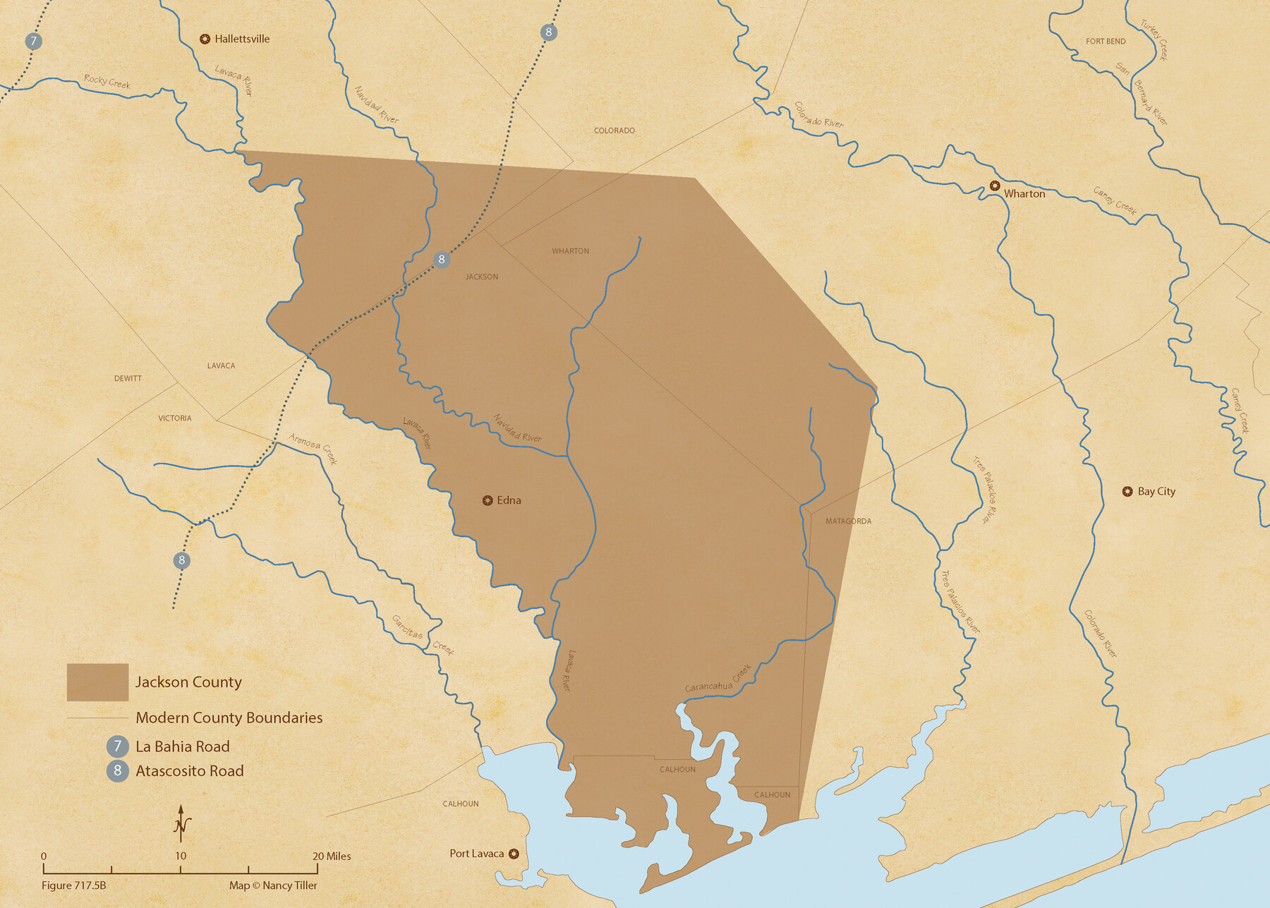
The Republic County of Jackson. January 19, 1841
Figure No. 717.5 from 'A Boundary Atlas of Texas, 1821-1845' by Jim Tiller
-
Map/Doc
96188
-
Collection
Nancy and Jim Tiller Digital Collection
-
Object Dates
2020/1/1 (Creation Date)
-
People and Organizations
Jim Tiller (Author)
Nancy Tiller (Cartographer)
Gang Gong (GIS Professional)
-
Counties
Jackson
-
Subjects
Atlas County Republic of Texas Texas Boundaries
-
Height x Width
15.6 x 21.8 inches
39.6 x 55.4 cm
-
Medium
digital image
-
Comments
To purchase a digital PDF copy of "A Boundary Atlas of Texas, 1821-1845" see 96437.
Part of: Nancy and Jim Tiller Digital Collection
The Republic County of Jackson. January 19, 1841

Print $20.00
The Republic County of Jackson. January 19, 1841
2020
Size 15.6 x 21.8 inches
Map/Doc 96188
The Republic County of Milam. December 29, 1845

Print $20.00
The Republic County of Milam. December 29, 1845
2020
Size 17.4 x 21.6 inches
Map/Doc 96233
The Coastal and Border League Lines

Print $20.00
The Coastal and Border League Lines
2020
Size 20.2 x 21.6 inches
Map/Doc 95977
The Republic County of Bexar. December 31, 1838

Print $20.00
The Republic County of Bexar. December 31, 1838
2020
Size 24.6 x 21.6 inches
Map/Doc 96096
From Citizens of Nacogdoches County Living Near the Sabine River for the Creation of a New Judicial County (Unnamed), Undated

Print $20.00
From Citizens of Nacogdoches County Living Near the Sabine River for the Creation of a New Judicial County (Unnamed), Undated
2020
Size 19.9 x 21.7 inches
Map/Doc 96411
The Empresario Grants. Arthur Goodall Wavell, Proposed Expansion

Print $20.00
The Empresario Grants. Arthur Goodall Wavell, Proposed Expansion
2020
Size 16.0 x 21.7 inches
Map/Doc 96427
The Republic of Texas, Defined, December 19, 1836

Print $20.00
The Republic of Texas, Defined, December 19, 1836
2020
Size 24.6 x 21.7 inches
Map/Doc 96036
The Republic County of Bowie. December 29, 1845

Print $20.00
The Republic County of Bowie. December 29, 1845
2020
Size 19.5 x 21.7 inches
Map/Doc 96108
The Republic County of Bexar. December 2, 1841

Print $20.00
The Republic County of Bexar. December 2, 1841
2020
Size 14.8 x 21.7 inches
Map/Doc 96098
The Republic County of Montgomery. December 29, 1845

Print $20.00
The Republic County of Montgomery. December 29, 1845
2020
Size 19.9 x 21.7 inches
Map/Doc 96241
The Republic County of Victoria. Proposed, Late Fall 1837

Print $20.00
The Republic County of Victoria. Proposed, Late Fall 1837
2020
Size 22.5 x 21.7 inches
Map/Doc 96294
The Republic County of Milam. February 4, 1840

Print $20.00
The Republic County of Milam. February 4, 1840
2020
Size 17.4 x 21.6 inches
Map/Doc 96229
You may also like
Bosque County

Print $40.00
- Digital $50.00
Bosque County
1945
Size 48.8 x 38.7 inches
Map/Doc 95432
[Resurvey of Block Number 01- W. H. Godair Surveys]
![92585, [Resurvey of Block Number 01- W. H. Godair Surveys], Twichell Survey Records](https://historictexasmaps.com/wmedia_w700/maps/92585-1.tif.jpg)
Print $20.00
- Digital $50.00
[Resurvey of Block Number 01- W. H. Godair Surveys]
1923
Size 33.9 x 14.9 inches
Map/Doc 92585
Township No. 4 South Range No. 16 West of the Indian Meridian

Print $20.00
- Digital $50.00
Township No. 4 South Range No. 16 West of the Indian Meridian
1875
Size 19.4 x 24.4 inches
Map/Doc 75165
Kerr County Rolled Sketch 24

Print $20.00
- Digital $50.00
Kerr County Rolled Sketch 24
Size 25.1 x 31.4 inches
Map/Doc 6504
Part of Matagorda Bay & Peninsula, Texas

Print $40.00
- Digital $50.00
Part of Matagorda Bay & Peninsula, Texas
1856
Size 31.8 x 51.4 inches
Map/Doc 69978
Wharton County Sketch File 9

Print $4.00
- Digital $50.00
Wharton County Sketch File 9
1884
Size 9.1 x 11.7 inches
Map/Doc 39929
Nueces County Sketch File 65

Print $18.00
- Digital $50.00
Nueces County Sketch File 65
1981
Size 11.2 x 8.6 inches
Map/Doc 32980
Flight Mission No. DQN-1K, Frame 141, Calhoun County

Print $20.00
- Digital $50.00
Flight Mission No. DQN-1K, Frame 141, Calhoun County
1953
Size 18.5 x 22.1 inches
Map/Doc 84204
Anderson County Rolled Sketch 9

Print $20.00
- Digital $50.00
Anderson County Rolled Sketch 9
Size 34.7 x 23.6 inches
Map/Doc 77156
Culberson County Working Sketch 88
Print $20.00
- Digital $50.00
Culberson County Working Sketch 88
1983
Size 32.8 x 37.1 inches
Map/Doc 68542
Bird's Eye View of Cuero, De Witt County, Texas

Print $20.00
Bird's Eye View of Cuero, De Witt County, Texas
1881
Size 18.4 x 25.5 inches
Map/Doc 89079
Hutchinson County Rolled Sketch 43

Print $40.00
- Digital $50.00
Hutchinson County Rolled Sketch 43
1992
Size 40.5 x 49.4 inches
Map/Doc 6312