Anderson County Rolled Sketch 9
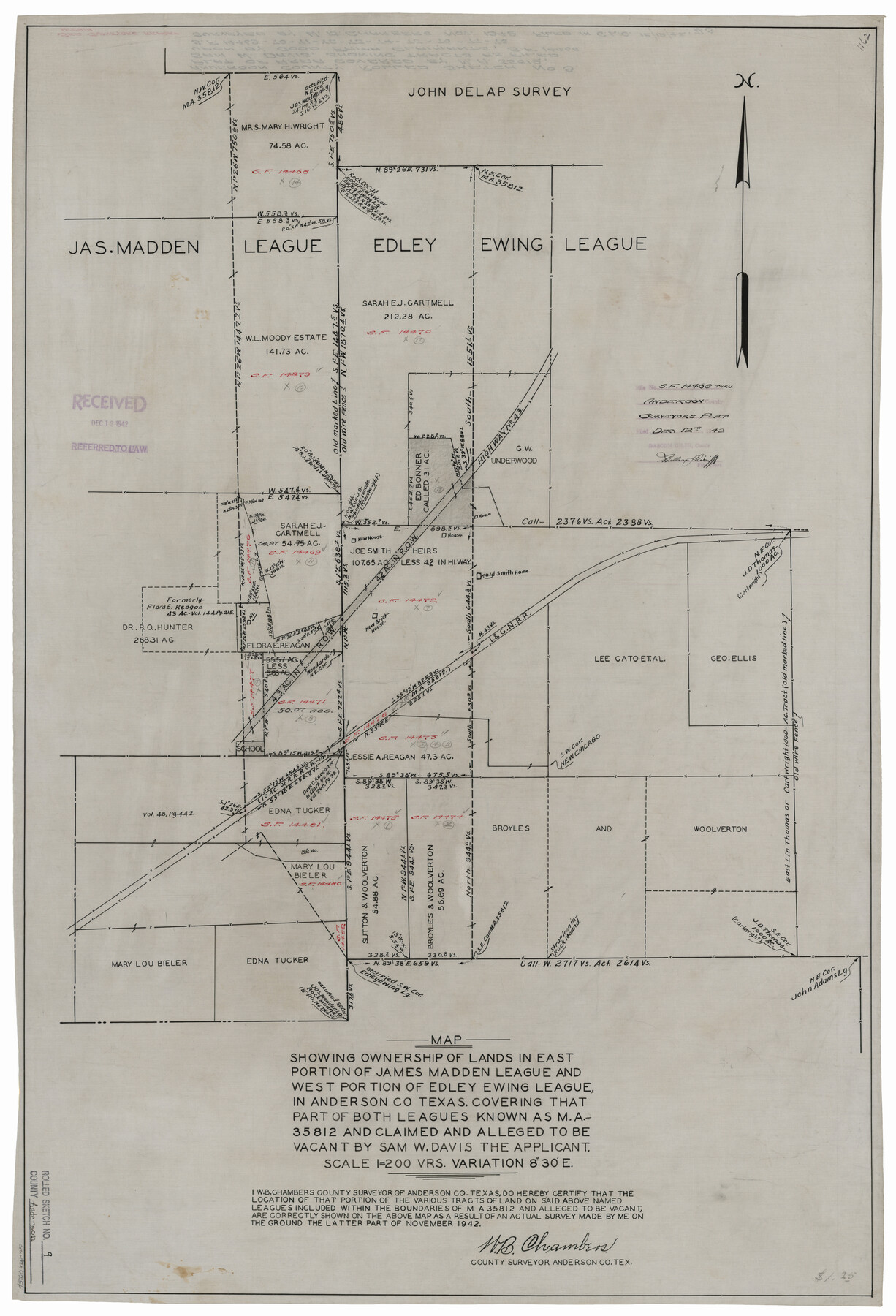
Map showing ownership of lands in east portion of James Madden League and west portion of Edley Ewing League, in Anderson Co. Texas. Covering that part of both leagues known as M.A.35812 and claimed and alleged to be vacant by Sam W. Davis the applicant
-
Map/Doc
77156
-
Collection
General Map Collection
-
Object Dates
11/1942 (Survey Date)
12/12/1942 (File Date)
-
People and Organizations
W.B. Chambers (Surveyor/Engineer)
-
Counties
Anderson
-
Subjects
Surveying Rolled Sketch
-
Height x Width
34.7 x 23.6 inches
88.1 x 59.9 cm
-
Medium
linen, manuscript
-
Scale
1" = 200 varas
-
Features
Highway 43
I&GN
Old Smith Home
Part of: General Map Collection
Flight Mission No. BRA-7M, Frame 145, Jefferson County

Print $20.00
- Digital $50.00
Flight Mission No. BRA-7M, Frame 145, Jefferson County
1953
Size 16.0 x 16.0 inches
Map/Doc 85539
Intracoastal Waterway in Texas - Corpus Christi to Point Isabel including Arroyo Colorado to Mo. Pac. R.R. Bridge Near Harlingen

Print $20.00
- Digital $50.00
Intracoastal Waterway in Texas - Corpus Christi to Point Isabel including Arroyo Colorado to Mo. Pac. R.R. Bridge Near Harlingen
1933
Size 27.9 x 41.0 inches
Map/Doc 61868
[Surveys in Jackson County]
![78354, [Surveys in Jackson County], General Map Collection](https://historictexasmaps.com/wmedia_w700/maps/78354.tif.jpg)
Print $20.00
- Digital $50.00
[Surveys in Jackson County]
Size 20.2 x 19.3 inches
Map/Doc 78354
[Houston & Texas Central Ry.]
![64363, [Houston & Texas Central Ry.], General Map Collection](https://historictexasmaps.com/wmedia_w700/maps/64363.tif.jpg)
Print $20.00
- Digital $50.00
[Houston & Texas Central Ry.]
1939
Size 15.5 x 13.8 inches
Map/Doc 64363
Crane County Sketch File 22

Print $20.00
- Digital $50.00
Crane County Sketch File 22
1930
Size 30.6 x 31.1 inches
Map/Doc 10344
Dickens County Sketch File 8

Print $4.00
- Digital $50.00
Dickens County Sketch File 8
Size 8.8 x 14.2 inches
Map/Doc 20971
Supreme Court of the United States, October Term, 1923, No. 15, Original - The State of Oklahoma, Complainant vs. The State of Texas, Defendant, The United States, Intervener; Report of the Boundary Commissioners

Print $20.00
- Digital $50.00
Supreme Court of the United States, October Term, 1923, No. 15, Original - The State of Oklahoma, Complainant vs. The State of Texas, Defendant, The United States, Intervener; Report of the Boundary Commissioners
1923
Size 35.1 x 41.1 inches
Map/Doc 82996
Austin Old and New, a Mapguide to the Heart of the City including Capitol Complex & Government Buildings, Downtown Streets and Buildings, the University of Texas, Historical Sites, Parks & Trails, Sixth Street, Town Lake, Museums

Austin Old and New, a Mapguide to the Heart of the City including Capitol Complex & Government Buildings, Downtown Streets and Buildings, the University of Texas, Historical Sites, Parks & Trails, Sixth Street, Town Lake, Museums
Size 25.4 x 31.3 inches
Map/Doc 94379
Corpus Christi Pass

Print $20.00
- Digital $50.00
Corpus Christi Pass
Size 45.7 x 41.2 inches
Map/Doc 78454

Colorado River, Wharton to Bay City Sheet 1, Texas

Print $40.00
- Digital $50.00
Colorado River, Wharton to Bay City Sheet 1, Texas
1924
Size 73.9 x 38.9 inches
Map/Doc 65262
Stonewall County Rolled Sketch 35

Print $20.00
- Digital $50.00
Stonewall County Rolled Sketch 35
1983
Size 42.7 x 34.5 inches
Map/Doc 9971
You may also like
Reeves County Working Sketch 31

Print $20.00
- Digital $50.00
Reeves County Working Sketch 31
1969
Size 27.6 x 36.5 inches
Map/Doc 63474
Harris County Historic Topographic B

Print $20.00
- Digital $50.00
Harris County Historic Topographic B
1916
Size 25.5 x 19.2 inches
Map/Doc 65850
Selected List of Wells accompanying Map of Wyoming showing Test Wells for Oil and Gas, Anticlinal Axes, Oil and Gas Fields, Pipelines, Unit Areas, and Land 3 District Boundaries, 1949

Print $20.00
- Digital $50.00
Selected List of Wells accompanying Map of Wyoming showing Test Wells for Oil and Gas, Anticlinal Axes, Oil and Gas Fields, Pipelines, Unit Areas, and Land 3 District Boundaries, 1949
1949
Size 26.2 x 41.5 inches
Map/Doc 89690
Oso Creek, Cudahay Field (P-3) Sheet

Print $6.00
- Digital $50.00
Oso Creek, Cudahay Field (P-3) Sheet
1942
Size 30.6 x 33.8 inches
Map/Doc 65098

Map of Robertson County

Print $40.00
- Digital $50.00
Map of Robertson County
1840
Size 59.4 x 38.6 inches
Map/Doc 4655

Montgomery County Working Sketch 2

Print $20.00
- Digital $50.00
Montgomery County Working Sketch 2
1914
Size 14.5 x 23.2 inches
Map/Doc 71108
Nueces County Rolled Sketch 124

Print $20.00
- Digital $50.00
Nueces County Rolled Sketch 124
1997
Size 23.7 x 36.8 inches
Map/Doc 7159
Taylor County Sketch File 3

Print $4.00
- Digital $50.00
Taylor County Sketch File 3
Size 7.5 x 8.3 inches
Map/Doc 37778
Houston County

Print $40.00
- Digital $50.00
Houston County
1944
Size 49.3 x 51.0 inches
Map/Doc 76037
Hood County Sketch File 28

Print $84.00
- Digital $50.00
Hood County Sketch File 28
1880
Size 11.6 x 9.0 inches
Map/Doc 26631