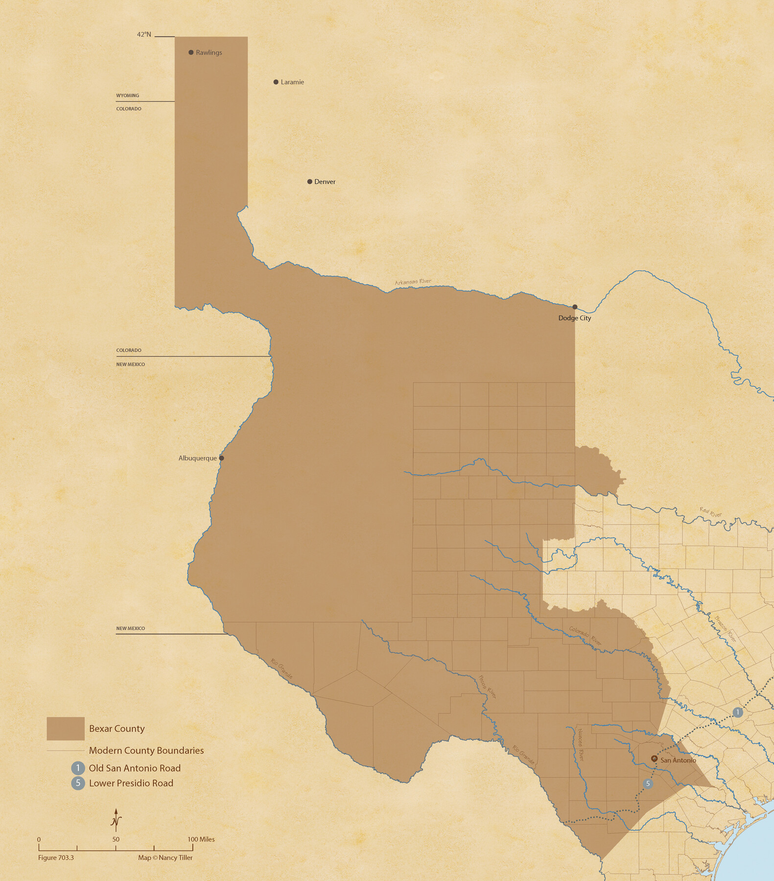
The Republic County of Bexar. December 31, 1838
Figure No. 703.3 from 'A Boundary Atlas of Texas, 1821-1845' by Jim Tiller
-
Map/Doc
96096
-
Collection
Nancy and Jim Tiller Digital Collection
-
Object Dates
2020/1/1 (Creation Date)
-
People and Organizations
Jim Tiller (Author)
Nancy Tiller (Cartographer)
Gang Gong (GIS Professional)
-
Counties
Bexar
-
Subjects
Atlas County Republic of Texas Texas Boundaries
-
Height x Width
24.6 x 21.6 inches
62.5 x 54.9 cm
-
Medium
digital image
-
Comments
To purchase a digital PDF copy of "A Boundary Atlas of Texas, 1821-1845" see 96437.
Part of: Nancy and Jim Tiller Digital Collection
The Republic County of Travis. Refined, February 5, 1840

Print $20.00
The Republic County of Travis. Refined, February 5, 1840
2020
Size 20.8 x 21.6 inches
Map/Doc 96290
The Land Offices. No. 6, Washington, December 22, 1836

Print $20.00
The Land Offices. No. 6, Washington, December 22, 1836
2020
Size 16.5 x 21.7 inches
Map/Doc 96419
The Fisher-Miller Colony. June 7, 1842

Print $20.00
The Fisher-Miller Colony. June 7, 1842
2020
Size 13.8 x 21.7 inches
Map/Doc 96358
From Citizens of Austin County Requesting to be Attached to Washington County, January 4, 1842

Print $20.00
From Citizens of Austin County Requesting to be Attached to Washington County, January 4, 1842
2020
Size 20.2 x 21.7 inches
Map/Doc 96396
The Republic County of Robertson. Created, December 14, 1837

Print $20.00
The Republic County of Robertson. Created, December 14, 1837
2020
Size 18.9 x 21.6 inches
Map/Doc 96259
The Chief Justice County of San Augustine. Lands in Conflict with Sabine County

Print $20.00
The Chief Justice County of San Augustine. Lands in Conflict with Sabine County
2020
Size 14.6 x 21.7 inches
Map/Doc 96071
The Judicial District/County of Waco. Created, January 29, 1842

Print $20.00
The Judicial District/County of Waco. Created, January 29, 1842
2020
Size 16.2 x 21.7 inches
Map/Doc 96352
The League Lines, Coastal and Border Reserves, with Surveys

Print $20.00
The League Lines, Coastal and Border Reserves, with Surveys
2020
Size 20.1 x 21.7 inches
Map/Doc 96426
From Citizens of Nacogdoches County for the Creation of a New County to be Called Smith, September 4, 1841

Print $20.00
From Citizens of Nacogdoches County for the Creation of a New County to be Called Smith, September 4, 1841
2020
Size 18.3 x 21.7 inches
Map/Doc 96392
The Republic County of Lamar. January 28, 1841

Print $20.00
The Republic County of Lamar. January 28, 1841
2020
Size 16.4 x 21.7 inches
Map/Doc 96203
The Mexican Municipality of Gonzales. Proposed, No Date

Print $20.00
The Mexican Municipality of Gonzales. Proposed, No Date
2020
Size 20.4 x 21.7 inches
Map/Doc 96020
The Chief Justice County of Brazoria. Lands in Conflict with Colorado, Harrisburg, Matagorda Counties

Print $20.00
The Chief Justice County of Brazoria. Lands in Conflict with Colorado, Harrisburg, Matagorda Counties
2020
Size 14.8 x 21.7 inches
Map/Doc 96043
You may also like
Fort Bend County Rolled Sketch 17

Print $20.00
- Digital $50.00
Fort Bend County Rolled Sketch 17
1997
Size 28.0 x 38.5 inches
Map/Doc 5901
Flight Mission No. CRC-1R, Frame 96, Chambers County

Print $20.00
- Digital $50.00
Flight Mission No. CRC-1R, Frame 96, Chambers County
1956
Size 18.6 x 22.3 inches
Map/Doc 84711
Red River County Rolled Sketch 7A

Print $20.00
- Digital $50.00
Red River County Rolled Sketch 7A
Size 28.3 x 33.1 inches
Map/Doc 7472
Bell County Sketch File 13

Print $4.00
- Digital $50.00
Bell County Sketch File 13
1854
Size 9.3 x 8.1 inches
Map/Doc 14390
![91655, [Capitol Lands], Twichell Survey Records](https://historictexasmaps.com/wmedia_w700/maps/91655-1.tif.jpg)
Flight Mission No. BRE-1P, Frame 127, Nueces County

Print $20.00
- Digital $50.00
Flight Mission No. BRE-1P, Frame 127, Nueces County
1956
Size 18.7 x 22.6 inches
Map/Doc 86693
Traced from Genl. Arista's map captured by the American Army under Genl. Taylor at Resaca de la Palma 9th May '46 and presented to James K. Polk, President U. States

Print $20.00
- Digital $50.00
Traced from Genl. Arista's map captured by the American Army under Genl. Taylor at Resaca de la Palma 9th May '46 and presented to James K. Polk, President U. States
1846
Size 18.2 x 27.3 inches
Map/Doc 73060
Webb County Working Sketch 83

Print $20.00
- Digital $50.00
Webb County Working Sketch 83
1980
Size 20.7 x 34.9 inches
Map/Doc 72450
Nolan County Working Sketch 2

Print $20.00
- Digital $50.00
Nolan County Working Sketch 2
1943
Size 26.7 x 25.0 inches
Map/Doc 71293
Travis County Sketch File 62

Print $20.00
- Digital $50.00
Travis County Sketch File 62
1929
Size 20.6 x 18.2 inches
Map/Doc 12473
Morton, Cochran County, Texas / Morton Cemetery First Addition, Cochran County, Texas

Print $20.00
- Digital $50.00
Morton, Cochran County, Texas / Morton Cemetery First Addition, Cochran County, Texas
Size 37.4 x 40.3 inches
Map/Doc 89853
Flight Mission No. DAG-23K, Frame 147, Matagorda County

Print $20.00
- Digital $50.00
Flight Mission No. DAG-23K, Frame 147, Matagorda County
1953
Size 15.8 x 15.6 inches
Map/Doc 86495