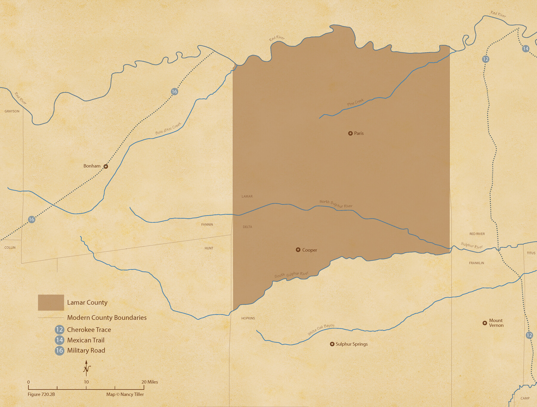
The Republic County of Lamar. January 28, 1841
Figure No. 720.2 from 'A Boundary Atlas of Texas, 1821-1845' by Jim Tiller
-
Map/Doc
96203
-
Collection
Nancy and Jim Tiller Digital Collection
-
Object Dates
2020/1/1 (Creation Date)
-
People and Organizations
Jim Tiller (Author)
Nancy Tiller (Cartographer)
Gang Gong (GIS Professional)
-
Counties
Lamar
-
Subjects
Atlas County Republic of Texas Texas Boundaries
-
Height x Width
16.4 x 21.7 inches
41.7 x 55.1 cm
-
Medium
digital image
-
Comments
To purchase a digital PDF copy of "A Boundary Atlas of Texas, 1821-1845" see 96437.
Part of: Nancy and Jim Tiller Digital Collection
The Chief Justice County of Mina. April 24, 1837

Print $20.00
The Chief Justice County of Mina. April 24, 1837
2020
Size 15.8 x 21.7 inches
Map/Doc 96061
The Republic County of Matagorda. Spring 1842

Print $20.00
The Republic County of Matagorda. Spring 1842
2020
Size 21.0 x 21.7 inches
Map/Doc 96222
The Republic County of Lamar. December 29, 1845

Print $20.00
The Republic County of Lamar. December 29, 1845
2020
Size 16.4 x 21.7 inches
Map/Doc 96207
The Land Offices. No. 6, Washington, December 22, 1836

Print $20.00
The Land Offices. No. 6, Washington, December 22, 1836
2020
Size 16.5 x 21.7 inches
Map/Doc 96419
The Republic County of Washington. January 29, 1842

Print $20.00
The Republic County of Washington. January 29, 1842
2020
Size 11.8 x 21.7 inches
Map/Doc 96307

The Mexican Municipality of Sabine. Created, December 15, 1835

Print $20.00
The Mexican Municipality of Sabine. Created, December 15, 1835
2020
Size 22.7 x 21.7 inches
Map/Doc 96031
The Land Offices. No. 3, Liberty, December 22, 1836

Print $20.00
The Land Offices. No. 3, Liberty, December 22, 1836
2020
Size 16.0 x 21.7 inches
Map/Doc 96416
The Republic County of Houston. January 30, 1841

Print $20.00
The Republic County of Houston. January 30, 1841
2020
Size 19.7 x 21.8 inches
Map/Doc 96179
The Chief Justice County of Refugio. Proposed, No Date

Print $20.00
The Chief Justice County of Refugio. Proposed, No Date
2020
Size 22.6 x 21.7 inches
Map/Doc 96067
The Republic County of Washington. January 30, 1841

Print $20.00
The Republic County of Washington. January 30, 1841
2020
Size 20.3 x 21.7 inches
Map/Doc 96305
Text (Possibly Legislative) Describing the Boundaries of Washington County, Undated

Print $20.00
Text (Possibly Legislative) Describing the Boundaries of Washington County, Undated
2020
Size 20.0 x 21.7 inches
Map/Doc 96407
You may also like
Dimmit County Working Sketch 39

Print $20.00
- Digital $50.00
Dimmit County Working Sketch 39
1967
Size 25.5 x 30.0 inches
Map/Doc 68700
Presidio County Working Sketch 80

Print $20.00
- Digital $50.00
Presidio County Working Sketch 80
1967
Size 18.8 x 30.5 inches
Map/Doc 71757
Flight Mission No. DAG-21K, Frame 85, Matagorda County

Print $20.00
- Digital $50.00
Flight Mission No. DAG-21K, Frame 85, Matagorda County
1952
Size 18.5 x 22.3 inches
Map/Doc 86414
Slaton-Tex Water System

Print $20.00
- Digital $50.00
Slaton-Tex Water System
1922
Size 47.7 x 37.6 inches
Map/Doc 92818
Reeves County Boundary File 1

Print $12.00
- Digital $50.00
Reeves County Boundary File 1
Size 14.1 x 8.5 inches
Map/Doc 58195
Flight Mission No. CRC-4R, Frame 149, Chambers County

Print $20.00
- Digital $50.00
Flight Mission No. CRC-4R, Frame 149, Chambers County
1956
Size 18.7 x 22.4 inches
Map/Doc 84912
[Movements & Objectives of the 143rd & 144th Infantry and many other divisions and regiments, 1918]
![94138, [Movements & Objectives of the 143rd & 144th Infantry and many other divisions and regiments, 1918], Non-GLO Digital Images](https://historictexasmaps.com/wmedia_w700/maps/94138-1.tif.jpg)
Print $40.00
[Movements & Objectives of the 143rd & 144th Infantry and many other divisions and regiments, 1918]
1918
Size 64.2 x 37.5 inches
Map/Doc 94138
Titus County Working Sketch Graphic Index

Print $20.00
- Digital $50.00
Titus County Working Sketch Graphic Index
1948
Size 40.2 x 29.0 inches
Map/Doc 76714
General Highway Map, Kenedy County, Texas

Print $20.00
General Highway Map, Kenedy County, Texas
1940
Size 18.5 x 24.9 inches
Map/Doc 79154
A Portion of the State's Submerged Oil Field, Goose Creek - Harris County - Texas

Print $20.00
- Digital $50.00
A Portion of the State's Submerged Oil Field, Goose Creek - Harris County - Texas
1919
Size 14.2 x 17.3 inches
Map/Doc 3165
Hutchinson County Rolled Sketch 37A

Print $40.00
- Digital $50.00
Hutchinson County Rolled Sketch 37A
1950
Size 24.6 x 50.5 inches
Map/Doc 10676
Hutchinson County Rolled Sketch 10

Print $20.00
- Digital $50.00
Hutchinson County Rolled Sketch 10
Size 33.6 x 29.7 inches
Map/Doc 6281