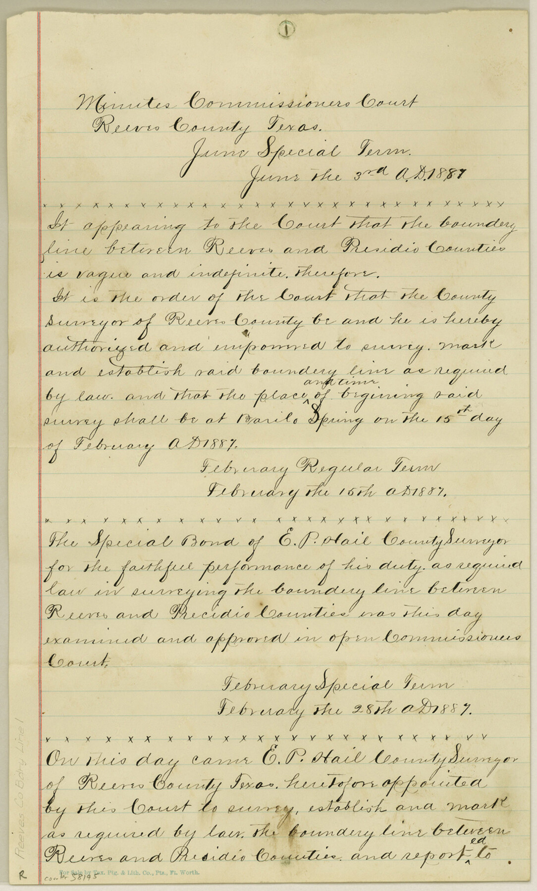
Reeves County Boundary File 1
[Court Order, Surveyor's Report, and Fieldnotes of the Boundary line between Presidio and Reeves Counties
-
Map/Doc
58195
-
Collection
General Map Collection
-
Counties
Reeves
-
Subjects
County Boundaries
-
Height x Width
14.1 x 8.5 inches
35.8 x 21.6 cm
Part of: General Map Collection
A General Map of the Southern British Colonies, in America. comprehending North and South Carolina, Georgia, East and West Florida, with the Neighbouring Indian Countries

Print $20.00
- Digital $50.00
A General Map of the Southern British Colonies, in America. comprehending North and South Carolina, Georgia, East and West Florida, with the Neighbouring Indian Countries
1776
Size 21.3 x 26.4 inches
Map/Doc 97403
Map of Navisota County

Print $20.00
- Digital $50.00
Map of Navisota County
Size 27.5 x 19.6 inches
Map/Doc 3328
Medina County Working Sketch 25

Print $20.00
- Digital $50.00
Medina County Working Sketch 25
1985
Size 37.6 x 42.9 inches
Map/Doc 70940
Foard County Sketch File 6

Print $4.00
- Digital $50.00
Foard County Sketch File 6
1875
Size 10.2 x 8.4 inches
Map/Doc 22808
[T. & G. Ry. Main Line, Texas, Right of Way Map, Center to Gary]
![64569, [T. & G. Ry. Main Line, Texas, Right of Way Map, Center to Gary], General Map Collection](https://historictexasmaps.com/wmedia_w700/maps/64569-1.tif.jpg)
Print $40.00
- Digital $50.00
[T. & G. Ry. Main Line, Texas, Right of Way Map, Center to Gary]
1917
Size 31.5 x 76.7 inches
Map/Doc 64569
United States Atlantic and Gulf Coasts Including Puerto Rico and the Virgin Islands

Print $40.00
- Digital $50.00
United States Atlantic and Gulf Coasts Including Puerto Rico and the Virgin Islands
1989
Size 21.4 x 60.4 inches
Map/Doc 73552
University Land in Cooke County

Print $20.00
- Digital $50.00
University Land in Cooke County
1906
Size 23.6 x 30.0 inches
Map/Doc 2425
Val Verde County Working Sketch 28

Print $20.00
- Digital $50.00
Val Verde County Working Sketch 28
1937
Size 45.9 x 38.6 inches
Map/Doc 72163
Victoria County Rolled Sketch 7

Print $40.00
- Digital $50.00
Victoria County Rolled Sketch 7
1945
Size 54.2 x 16.3 inches
Map/Doc 10098
Duval County Sketch File 45a

Print $9.00
- Digital $50.00
Duval County Sketch File 45a
Size 14.5 x 9.0 inches
Map/Doc 21396
Sketch J Showing the progress of the Survey of the Western Coast

Print $20.00
- Digital $50.00
Sketch J Showing the progress of the Survey of the Western Coast
1849
Size 12.3 x 10.0 inches
Map/Doc 97228
Parker County Working Sketch 27

Print $20.00
- Digital $50.00
Parker County Working Sketch 27
2009
Map/Doc 89001
You may also like
Dimmit County Rolled Sketch CHM

Print $20.00
- Digital $50.00
Dimmit County Rolled Sketch CHM
1935
Size 38.1 x 41.2 inches
Map/Doc 10716
Leon County Working Sketch 40

Print $20.00
- Digital $50.00
Leon County Working Sketch 40
1980
Size 31.4 x 20.5 inches
Map/Doc 70439
Schleicher County Sketch File 28

Print $40.00
- Digital $50.00
Schleicher County Sketch File 28
1939
Size 17.4 x 14.2 inches
Map/Doc 36526
Franklin County Working Sketch 1

Print $20.00
- Digital $50.00
Franklin County Working Sketch 1
1915
Size 20.4 x 11.8 inches
Map/Doc 69239
Marion County Working Sketch 39

Print $20.00
- Digital $50.00
Marion County Working Sketch 39
1991
Size 20.8 x 19.2 inches
Map/Doc 70815
1882 Map of the Texas & Pacific R-Y Reserve

Print $40.00
- Digital $50.00
1882 Map of the Texas & Pacific R-Y Reserve
1888
Size 95.6 x 42.5 inches
Map/Doc 2299
McLennan County Sketch File 42

Print $24.00
- Digital $50.00
McLennan County Sketch File 42
1868
Size 7.8 x 7.1 inches
Map/Doc 31331
Marion County Working Sketch 24

Print $20.00
- Digital $50.00
Marion County Working Sketch 24
1960
Size 21.4 x 26.4 inches
Map/Doc 70800
Flight Mission No. DQN-1K, Frame 31, Calhoun County

Print $20.00
- Digital $50.00
Flight Mission No. DQN-1K, Frame 31, Calhoun County
1953
Size 15.4 x 15.5 inches
Map/Doc 84136
Crane County Rolled Sketch REE

Print $40.00
- Digital $50.00
Crane County Rolled Sketch REE
1936
Size 50.6 x 34.1 inches
Map/Doc 8681
Pecos County Sketch File 76

Print $4.00
- Digital $50.00
Pecos County Sketch File 76
1943
Size 11.2 x 8.8 inches
Map/Doc 33907
Scurry County Rolled Sketch 7

Print $20.00
- Digital $50.00
Scurry County Rolled Sketch 7
1946
Size 23.5 x 10.4 inches
Map/Doc 7767