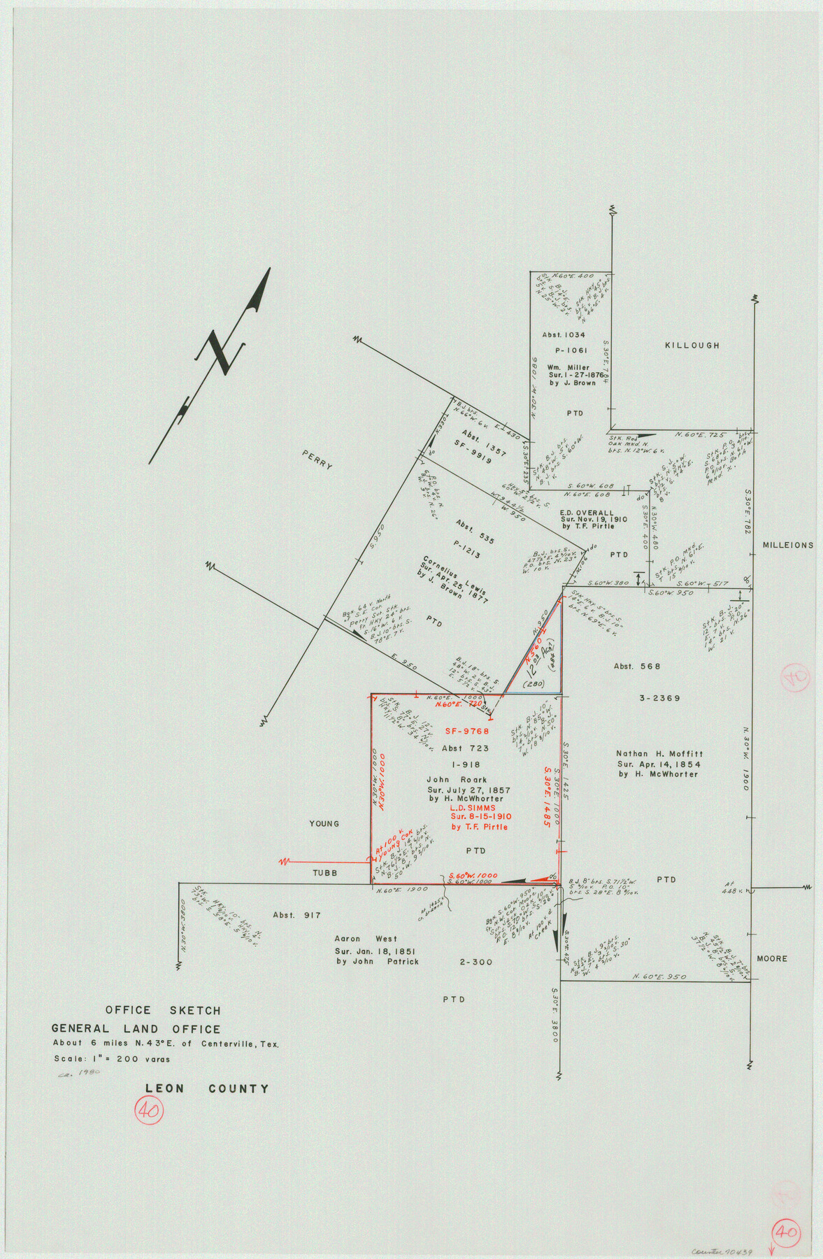
Leon County Working Sketch 40
-
Map/Doc
70439
-
Collection
General Map Collection
-
Object Dates
1980 ca. (Creation Date)
-
Counties
Leon
-
Subjects
Surveying Working Sketch
-
Height x Width
31.4 x 20.5 inches
79.8 x 52.1 cm
-
Scale
1" = 200 varas
Part of: General Map Collection
Right of Way & Track Map, St. Louis, Brownsville & Mexico Ry. operated by St. Louis, Brownsville & Mexico Ry. Co.

Print $40.00
- Digital $50.00
Right of Way & Track Map, St. Louis, Brownsville & Mexico Ry. operated by St. Louis, Brownsville & Mexico Ry. Co.
1919
Size 25.5 x 57.3 inches
Map/Doc 64622
Schleicher County Sketch File 10

Print $9.00
- Digital $50.00
Schleicher County Sketch File 10
1885
Size 12.7 x 8.2 inches
Map/Doc 36485
Schleicher County Sketch File 35

Print $20.00
- Digital $50.00
Schleicher County Sketch File 35
1951
Size 13.8 x 19.4 inches
Map/Doc 12308
Hutchinson County Rolled Sketch 39

Print $20.00
- Digital $50.00
Hutchinson County Rolled Sketch 39
1956
Size 29.5 x 32.1 inches
Map/Doc 7712
Howard County Working Sketch 7a

Print $40.00
- Digital $50.00
Howard County Working Sketch 7a
1950
Size 81.9 x 24.7 inches
Map/Doc 66273
Coryell County

Print $20.00
- Digital $50.00
Coryell County
1880
Size 25.6 x 25.6 inches
Map/Doc 3444
Chambers County Working Sketch 19

Print $20.00
- Digital $50.00
Chambers County Working Sketch 19
1965
Size 23.5 x 25.8 inches
Map/Doc 68002
Galveston County NRC Article 33.136 Location Key Sheet

Print $20.00
- Digital $50.00
Galveston County NRC Article 33.136 Location Key Sheet
1994
Size 27.0 x 21.8 inches
Map/Doc 77017
Reagan County Working Sketch 31

Print $20.00
- Digital $50.00
Reagan County Working Sketch 31
1964
Size 38.7 x 36.6 inches
Map/Doc 71873
[Map of Navarro County]
![81900, [Map of Navarro County], General Map Collection](https://historictexasmaps.com/wmedia_w700/maps/81900.tif.jpg)
Print $20.00
- Digital $50.00
[Map of Navarro County]
1858
Size 18.0 x 23.5 inches
Map/Doc 81900
A Topographical Map of the Government Tract Adjoining the City of Austin

Print $20.00
- Digital $50.00
A Topographical Map of the Government Tract Adjoining the City of Austin
1840
Size 41.8 x 37.5 inches
Map/Doc 4833
Edwards County Working Sketch 35

Print $20.00
- Digital $50.00
Edwards County Working Sketch 35
1948
Size 20.9 x 31.1 inches
Map/Doc 68911
You may also like
Webb County Rolled Sketch 14

Print $20.00
- Digital $50.00
Webb County Rolled Sketch 14
1915
Size 12.6 x 28.5 inches
Map/Doc 8178
Edwards County Working Sketch 97

Print $20.00
- Digital $50.00
Edwards County Working Sketch 97
1969
Size 25.5 x 27.6 inches
Map/Doc 68973
[Sketch showing town lots near railroad track]
![92087, [Sketch showing town lots near railroad track], Twichell Survey Records](https://historictexasmaps.com/wmedia_w700/maps/92087-1.tif.jpg)
Print $20.00
- Digital $50.00
[Sketch showing town lots near railroad track]
Size 22.9 x 9.4 inches
Map/Doc 92087
Sutton County Boundary File 4a

Print $4.00
- Digital $50.00
Sutton County Boundary File 4a
Size 10.7 x 8.4 inches
Map/Doc 59045

Victoria County Working Sketch 11

Print $20.00
- Digital $50.00
Victoria County Working Sketch 11
2004
Size 34.7 x 36.0 inches
Map/Doc 83591
Ward County State of Texas

Print $20.00
- Digital $50.00
Ward County State of Texas
1888
Size 22.6 x 26.0 inches
Map/Doc 4641
Sudan Cemetery Sudan, Texas

Print $20.00
- Digital $50.00
Sudan Cemetery Sudan, Texas
1925
Size 24.1 x 28.2 inches
Map/Doc 92403
Harris County Working Sketch 109

Print $20.00
- Digital $50.00
Harris County Working Sketch 109
1981
Size 21.4 x 27.2 inches
Map/Doc 66001
Limestone County Sketch File 11

Print $4.00
- Digital $50.00
Limestone County Sketch File 11
1881
Size 7.9 x 9.5 inches
Map/Doc 30177
Wichita County Rolled Sketch 7

Print $20.00
- Digital $50.00
Wichita County Rolled Sketch 7
Size 14.7 x 16.4 inches
Map/Doc 8244
Milam County Sketch File 2

Print $4.00
- Digital $50.00
Milam County Sketch File 2
1849
Size 8.0 x 12.4 inches
Map/Doc 31627