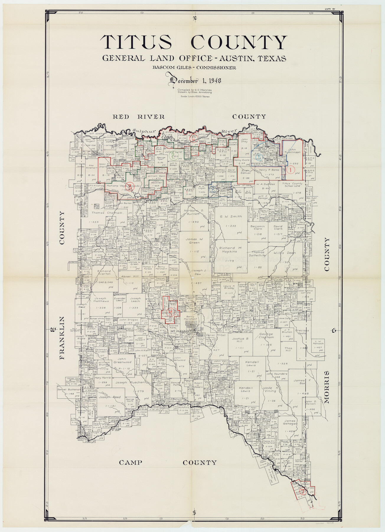
Titus County Working Sketch Graphic Index
-
Map/Doc
76714
-
Collection
General Map Collection
-
Object Dates
12/1/1948 (Creation Date)
-
People and Organizations
G.C. Morriss (Compiler)
Eltea Armstrong (Draftsman)
-
Counties
Titus
-
Subjects
County Surveying Working Sketch
-
Height x Width
40.2 x 29.0 inches
102.1 x 73.7 cm
-
Scale
1" = 2000 varas
Part of: General Map Collection
Galveston County Sketch File 26

Print $4.00
- Digital $50.00
Galveston County Sketch File 26
1860
Size 11.8 x 5.7 inches
Map/Doc 23397
Jim Hogg County Sketch File 10

Print $22.00
- Digital $50.00
Jim Hogg County Sketch File 10
1947
Size 14.3 x 8.7 inches
Map/Doc 28423
Aransas Pass to Baffin Bay

Print $20.00
- Digital $50.00
Aransas Pass to Baffin Bay
1961
Size 42.1 x 35.4 inches
Map/Doc 73414

Flight Mission No. DIX-7P, Frame 23, Aransas County

Print $20.00
- Digital $50.00
Flight Mission No. DIX-7P, Frame 23, Aransas County
1956
Size 18.7 x 22.4 inches
Map/Doc 83875
Karnes County Boundary File 5

Print $32.00
- Digital $50.00
Karnes County Boundary File 5
Size 12.7 x 8.2 inches
Map/Doc 55705
Montague County Working Sketch 20

Print $20.00
- Digital $50.00
Montague County Working Sketch 20
1952
Size 23.0 x 37.0 inches
Map/Doc 71086
Flight Mission No. BRE-1P, Frame 77, Nueces County

Print $20.00
- Digital $50.00
Flight Mission No. BRE-1P, Frame 77, Nueces County
1956
Size 18.4 x 22.2 inches
Map/Doc 86659
Parker County Sketch File 46

Print $26.00
- Digital $50.00
Parker County Sketch File 46
1957
Size 11.2 x 8.5 inches
Map/Doc 33615
Calhoun County Rolled Sketch 18

Print $20.00
- Digital $50.00
Calhoun County Rolled Sketch 18
1952
Size 12.2 x 11.9 inches
Map/Doc 5371
Presidio County Sketch File 77

Print $20.00
- Digital $50.00
Presidio County Sketch File 77
Size 21.8 x 17.9 inches
Map/Doc 11721
Navigation Maps of Gulf Intracoastal Waterway, Port Arthur to Brownsville, Texas

Print $4.00
- Digital $50.00
Navigation Maps of Gulf Intracoastal Waterway, Port Arthur to Brownsville, Texas
1951
Size 16.7 x 21.5 inches
Map/Doc 65443
You may also like
[Surveys in Bastrop County]
![3179, [Surveys in Bastrop County], General Map Collection](https://historictexasmaps.com/wmedia_w700/maps/3179.tif.jpg)
Print $2.00
- Digital $50.00
[Surveys in Bastrop County]
1841
Size 11.3 x 8.4 inches
Map/Doc 3179
Presidio County Rolled Sketch 95

Print $20.00
- Digital $50.00
Presidio County Rolled Sketch 95
1949
Size 45.4 x 37.5 inches
Map/Doc 9781
[Map of Henderson County]
![76767, [Map of Henderson County], General Map Collection](https://historictexasmaps.com/wmedia_w700/maps/76767.tif.jpg)
Print $20.00
- Digital $50.00
[Map of Henderson County]
1854
Size 29.7 x 22.0 inches
Map/Doc 76767
Hudspeth County Rolled Sketch 75

Print $40.00
- Digital $50.00
Hudspeth County Rolled Sketch 75
1992
Size 35.6 x 48.9 inches
Map/Doc 9238
Burnet County Working Sketch 13

Print $40.00
- Digital $50.00
Burnet County Working Sketch 13
1977
Size 40.5 x 49.2 inches
Map/Doc 67856
Starr County Sketch File 39

Print $20.00
- Digital $50.00
Starr County Sketch File 39
1940
Size 22.9 x 22.1 inches
Map/Doc 12339
La Salle County Sketch File 2

Print $14.00
- Digital $50.00
La Salle County Sketch File 2
1857
Size 10.1 x 15.5 inches
Map/Doc 29445
Yoakum County Sketch File 3

Print $54.00
- Digital $50.00
Yoakum County Sketch File 3
1892
Size 14.2 x 8.8 inches
Map/Doc 40705
![92632, [League 280], Twichell Survey Records](https://historictexasmaps.com/wmedia_w700/maps/92632-1.tif.jpg)
Moore County Sketch File 6

Print $16.00
- Digital $50.00
Moore County Sketch File 6
1902
Size 7.3 x 8.6 inches
Map/Doc 31939
Schleicher County Sketch File 39

Print $9.00
- Digital $50.00
Schleicher County Sketch File 39
1958
Size 14.8 x 9.4 inches
Map/Doc 36538
English Field Notes of the Spanish Archives - Book 2

English Field Notes of the Spanish Archives - Book 2
1835
Map/Doc 96528