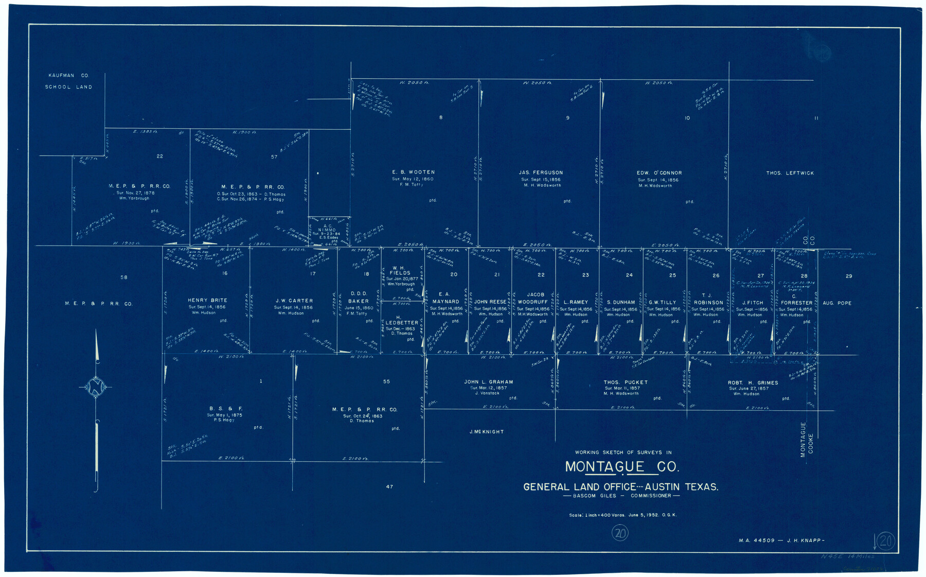
Montague County Working Sketch 20
-
Map/Doc
71086
-
Collection
General Map Collection
-
Object Dates
6/5/1952 (Creation Date)
-
People and Organizations
Otto G. Kurio (Draftsman)
-
Counties
Montague
-
Subjects
Surveying Working Sketch
-
Height x Width
23.0 x 37.0 inches
58.4 x 94.0 cm
-
Scale
1" = 400 varas
Part of: General Map Collection
Flight Mission No. CGI-3N, Frame 138, Cameron County

Print $20.00
- Digital $50.00
Flight Mission No. CGI-3N, Frame 138, Cameron County
1954
Size 18.7 x 22.2 inches
Map/Doc 84611
Cooke County Sketch File 10

Print $4.00
- Digital $50.00
Cooke County Sketch File 10
1855
Size 13.0 x 8.4 inches
Map/Doc 19242
Wilson County Working Sketch Graphic Index

Print $20.00
- Digital $50.00
Wilson County Working Sketch Graphic Index
1921
Size 39.5 x 47.7 inches
Map/Doc 76743
Carta General de la República Mexicana Formada en vista de los datos mas recientes y exactos que se han reunido con tal objeto, y constan en la noticia presentada al Exmo. Sr. Ministro de Fomento, por Antonio García y Cubas

Print $20.00
- Digital $50.00
Carta General de la República Mexicana Formada en vista de los datos mas recientes y exactos que se han reunido con tal objeto, y constan en la noticia presentada al Exmo. Sr. Ministro de Fomento, por Antonio García y Cubas
Size 23.3 x 29.2 inches
Map/Doc 95824
Starr County Working Sketch 29

Print $20.00
- Digital $50.00
Starr County Working Sketch 29
2007
Size 28.6 x 34.0 inches
Map/Doc 87208
Gillespie County Boundary File 5a

Print $2.00
- Digital $50.00
Gillespie County Boundary File 5a
Size 8.3 x 7.9 inches
Map/Doc 53769
Hunt County Sketch File 33

Print $4.00
- Digital $50.00
Hunt County Sketch File 33
1864
Size 7.1 x 5.0 inches
Map/Doc 27141
Flight Mission No. CGI-3N, Frame 147, Cameron County

Print $20.00
- Digital $50.00
Flight Mission No. CGI-3N, Frame 147, Cameron County
1954
Size 18.8 x 22.4 inches
Map/Doc 84620
Jeff Davis County Rolled Sketch 19A

Print $20.00
- Digital $50.00
Jeff Davis County Rolled Sketch 19A
Size 33.3 x 39.0 inches
Map/Doc 9266
Polk County Working Sketch 43

Print $20.00
- Digital $50.00
Polk County Working Sketch 43
1997
Size 23.2 x 30.5 inches
Map/Doc 71660
Harris County Historic Topographic 10

Print $20.00
- Digital $50.00
Harris County Historic Topographic 10
1916
Size 30.2 x 22.9 inches
Map/Doc 65820
Gregg County Sketch File 1D

Print $4.00
- Digital $50.00
Gregg County Sketch File 1D
1848
Size 12.7 x 8.5 inches
Map/Doc 24543
You may also like
Hardin County Working Sketch 25

Print $20.00
- Digital $50.00
Hardin County Working Sketch 25
1950
Size 10.8 x 20.1 inches
Map/Doc 63423
Montague County Working Sketch 10

Print $20.00
- Digital $50.00
Montague County Working Sketch 10
1940
Size 13.1 x 28.2 inches
Map/Doc 71076
Exeter and Wilson Empresario Colony. September 23, 1828

Print $20.00
Exeter and Wilson Empresario Colony. September 23, 1828
2020
Size 15.5 x 21.7 inches
Map/Doc 95994
[Blocks 3, Q, and vicinity]
![91274, [Blocks 3, Q, and vicinity], Twichell Survey Records](https://historictexasmaps.com/wmedia_w700/maps/91274-1.tif.jpg)
Print $20.00
- Digital $50.00
[Blocks 3, Q, and vicinity]
Size 19.4 x 8.9 inches
Map/Doc 91274
[Map of Burnet County]
![4512, [Map of Burnet County], General Map Collection](https://historictexasmaps.com/wmedia_w700/maps/4512-2.tif.jpg)
Print $20.00
- Digital $50.00
[Map of Burnet County]
1856
Size 26.3 x 23.1 inches
Map/Doc 4512
Colorado County Sketch File 3b

Print $4.00
- Digital $50.00
Colorado County Sketch File 3b
Size 7.0 x 8.2 inches
Map/Doc 18913
Bee County Sketch File 2

Print $40.00
- Digital $50.00
Bee County Sketch File 2
Size 14.3 x 13.0 inches
Map/Doc 14259
Historia de Nueva-España, escrita por su esclarecido conquistador Hernan Cortes, aumentada con otros documentos, y notas, por el ilustrissimo señor don Francisco Antonio Lorenzana, Arzobispo de Mexico

Historia de Nueva-España, escrita por su esclarecido conquistador Hernan Cortes, aumentada con otros documentos, y notas, por el ilustrissimo señor don Francisco Antonio Lorenzana, Arzobispo de Mexico
1770
Map/Doc 97351
General Highway Map, Kerr County, Texas

Print $20.00
General Highway Map, Kerr County, Texas
1961
Size 24.6 x 18.2 inches
Map/Doc 79552
Anderson County

Print $20.00
- Digital $50.00
Anderson County
1871
Size 20.2 x 21.9 inches
Map/Doc 3227
Laguna Madre, T-9211

Print $20.00
- Digital $50.00
Laguna Madre, T-9211
Size 33.0 x 31.1 inches
Map/Doc 73602
Atascosa County Rolled Sketch 27

Print $20.00
- Digital $50.00
Atascosa County Rolled Sketch 27
2012
Size 25.9 x 34.1 inches
Map/Doc 95410