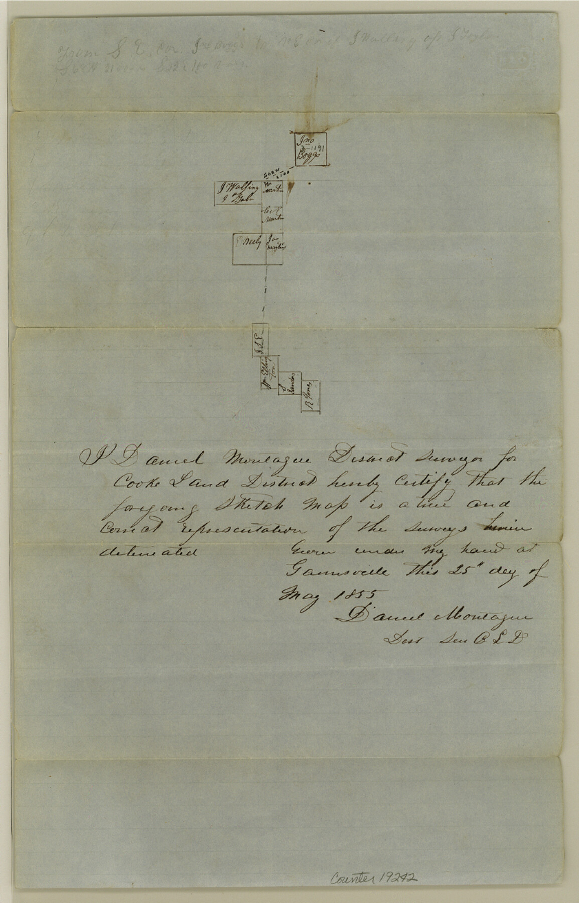
Cooke County Sketch File 10
[Sketch of surveys north of Brown Creek, west of Elm Fork of Trinity]
-
Map/Doc
19242
-
Collection
General Map Collection
-
Object Dates
1855/5/25 (Creation Date)
-
People and Organizations
Daniel Montague (Surveyor/Engineer)
-
Counties
Cooke
-
Subjects
Surveying Sketch File
-
Height x Width
13.0 x 8.4 inches
33.0 x 21.3 cm
-
Medium
paper, manuscript
-
Features
[Brown Creek]
[Elm Fork of Trinity River]
Part of: General Map Collection
Cherokee County Working Sketch 20

Print $40.00
- Digital $50.00
Cherokee County Working Sketch 20
1967
Size 37.6 x 61.1 inches
Map/Doc 67975
The Land of Open Sky - Southwest U.S.A.

The Land of Open Sky - Southwest U.S.A.
Size 20.2 x 15.6 inches
Map/Doc 95945
Garza County Boundary File 3

Print $76.00
- Digital $50.00
Garza County Boundary File 3
Size 11.4 x 9.0 inches
Map/Doc 53683
Calhoun County Rolled Sketch 14

Print $20.00
- Digital $50.00
Calhoun County Rolled Sketch 14
Size 22.1 x 40.5 inches
Map/Doc 5454
Cameron County Boundary File 2

Print $60.00
- Digital $50.00
Cameron County Boundary File 2
Size 47.8 x 22.1 inches
Map/Doc 51095
Upton County Rolled Sketch 24

Print $20.00
- Digital $50.00
Upton County Rolled Sketch 24
1886
Size 17.3 x 43.5 inches
Map/Doc 10043
Hardin County Working Sketch Graphic Index

Print $20.00
- Digital $50.00
Hardin County Working Sketch Graphic Index
1940
Size 45.1 x 45.0 inches
Map/Doc 76567
Zavala County Working Sketch 23

Print $40.00
- Digital $50.00
Zavala County Working Sketch 23
1980
Size 77.3 x 43.6 inches
Map/Doc 62098
Map of Atascosa Co.

Print $40.00
- Digital $50.00
Map of Atascosa Co.
1894
Size 48.3 x 46.6 inches
Map/Doc 4877
Webb County Working Sketch 24

Print $20.00
- Digital $50.00
Webb County Working Sketch 24
1928
Size 24.5 x 23.9 inches
Map/Doc 72389
Floyd County Sketch File 12

Print $10.00
- Digital $50.00
Floyd County Sketch File 12
1913
Size 10.8 x 8.8 inches
Map/Doc 22708
Mitchell County Working Sketch 1

Print $20.00
- Digital $50.00
Mitchell County Working Sketch 1
1905
Size 24.2 x 20.7 inches
Map/Doc 71058
You may also like
Old Miscellaneous File 5

Print $4.00
- Digital $50.00
Old Miscellaneous File 5
1846
Size 4.8 x 7.6 inches
Map/Doc 75418
From Citizens of Shelby and Red River Counties Living East of the Sabine River and Southwest of the Sulphur Fork of Red River for the Creation of a New County to be Called Green, March 11, 1837/April 1, 1837

Print $20.00
From Citizens of Shelby and Red River Counties Living East of the Sabine River and Southwest of the Sulphur Fork of Red River for the Creation of a New County to be Called Green, March 11, 1837/April 1, 1837
2020
Size 24.3 x 21.7 inches
Map/Doc 96373
Grimes County Working Sketch Graphic Index

Print $40.00
- Digital $50.00
Grimes County Working Sketch Graphic Index
1922
Size 54.9 x 29.4 inches
Map/Doc 76560
Brazos River, Widths of Floodways/Brazos and Navasota Rivers

Print $20.00
- Digital $50.00
Brazos River, Widths of Floodways/Brazos and Navasota Rivers
1921
Size 38.1 x 24.5 inches
Map/Doc 65292
Nautical Chart 518-SC: Galveston Bay Entrance

Print $20.00
- Digital $50.00
Nautical Chart 518-SC: Galveston Bay Entrance
1971
Size 19.2 x 19.1 inches
Map/Doc 75909
Flight Mission No. BRE-1P, Frame 78, Nueces County

Print $20.00
- Digital $50.00
Flight Mission No. BRE-1P, Frame 78, Nueces County
1956
Size 18.6 x 22.4 inches
Map/Doc 86660
[Texas Panhandle North Boundary Line]

Print $20.00
- Digital $50.00
[Texas Panhandle North Boundary Line]
1898
Size 11.9 x 46.1 inches
Map/Doc 1737
[Beaumont, Sour Lake and Western Ry. Right of Way and Alignment - Frisco]
![64115, [Beaumont, Sour Lake and Western Ry. Right of Way and Alignment - Frisco], General Map Collection](https://historictexasmaps.com/wmedia_w700/maps/64115.tif.jpg)
Print $20.00
- Digital $50.00
[Beaumont, Sour Lake and Western Ry. Right of Way and Alignment - Frisco]
1910
Size 20.1 x 45.9 inches
Map/Doc 64115
Freestone County

Print $40.00
- Digital $50.00
Freestone County
1918
Size 48.4 x 41.6 inches
Map/Doc 66830
Sutton County Working Sketch 22

Print $20.00
- Digital $50.00
Sutton County Working Sketch 22
1981
Size 33.7 x 33.4 inches
Map/Doc 62365
Flight Mission No. CGI-3N, Frame 167, Cameron County

Print $20.00
- Digital $50.00
Flight Mission No. CGI-3N, Frame 167, Cameron County
1954
Size 18.6 x 22.4 inches
Map/Doc 84631
Map showing A. & N. W., Raymond Word #3, S.S. Hervey #496, and M. Farley #495 corrected to conform to the judgement in Cause #2888, Travis County District Court, State of Texas versus D. Sullivan, et al

Print $20.00
- Digital $50.00
Map showing A. & N. W., Raymond Word #3, S.S. Hervey #496, and M. Farley #495 corrected to conform to the judgement in Cause #2888, Travis County District Court, State of Texas versus D. Sullivan, et al
1915
Size 18.5 x 30.0 inches
Map/Doc 75812