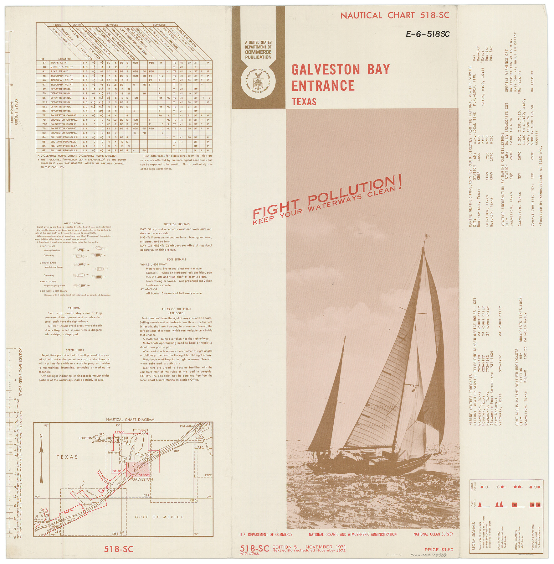
Nautical Chart 518-SC: Galveston Bay Entrance
E-6-518sc
-
Map/Doc
75909
-
Collection
General Map Collection
-
Object Dates
1971 (Creation Date)
-
Counties
Galveston
-
Subjects
Nautical Charts
-
Height x Width
19.2 x 19.1 inches
48.8 x 48.5 cm
Part of: General Map Collection
Donley County Rolled Sketch 3A

Print $20.00
- Digital $50.00
Donley County Rolled Sketch 3A
1946
Size 15.2 x 22.6 inches
Map/Doc 5730
Flight Mission No. BRA-16M, Frame 175, Jefferson County

Print $20.00
- Digital $50.00
Flight Mission No. BRA-16M, Frame 175, Jefferson County
1953
Size 18.6 x 22.4 inches
Map/Doc 85773
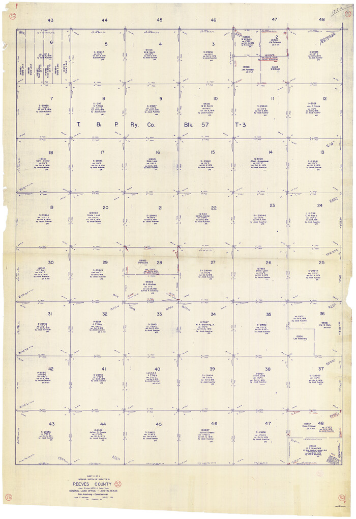
Reeves County Working Sketch 52
Print $40.00
- Digital $50.00
Reeves County Working Sketch 52
1977
Size 60.3 x 41.9 inches
Map/Doc 63495
Uvalde County Working Sketch 46

Print $20.00
- Digital $50.00
Uvalde County Working Sketch 46
1979
Size 37.1 x 26.3 inches
Map/Doc 72116
Montgomery County Working Sketch 41

Print $20.00
- Digital $50.00
Montgomery County Working Sketch 41
1955
Size 22.9 x 23.6 inches
Map/Doc 71148
Angelina County Sketch File 16a

Print $62.00
- Digital $50.00
Angelina County Sketch File 16a
1862
Size 6.0 x 8.3 inches
Map/Doc 13009
Kendall County

Print $20.00
- Digital $50.00
Kendall County
1946
Size 41.1 x 35.3 inches
Map/Doc 77336
Old Miscellaneous File 17

Print $24.00
- Digital $50.00
Old Miscellaneous File 17
1908
Size 14.2 x 8.6 inches
Map/Doc 75485
Webb County Sketch File 66

Print $20.00
- Digital $50.00
Webb County Sketch File 66
1950
Size 13.4 x 20.6 inches
Map/Doc 12655
Blanco County Working Sketch 41

Print $20.00
- Digital $50.00
Blanco County Working Sketch 41
1986
Size 28.4 x 25.2 inches
Map/Doc 67401
Flight Mission No. CGI-3N, Frame 46, Cameron County

Print $20.00
- Digital $50.00
Flight Mission No. CGI-3N, Frame 46, Cameron County
1954
Size 18.7 x 22.2 inches
Map/Doc 84552
Palo Pinto County Working Sketch 8

Print $20.00
- Digital $50.00
Palo Pinto County Working Sketch 8
1922
Map/Doc 71391
You may also like
Maps of Gulf Intracoastal Waterway, Texas - Sabine River to the Rio Grande and connecting waterways including ship channels

Print $20.00
- Digital $50.00
Maps of Gulf Intracoastal Waterway, Texas - Sabine River to the Rio Grande and connecting waterways including ship channels
1966
Size 14.5 x 22.2 inches
Map/Doc 61922
Mills County Rolled Sketch 6

Print $20.00
- Digital $50.00
Mills County Rolled Sketch 6
2007
Size 24.4 x 36.6 inches
Map/Doc 88738
Flight Mission No. CUI-1H, Frame 97, Milam County

Print $20.00
- Digital $50.00
Flight Mission No. CUI-1H, Frame 97, Milam County
1951
Size 18.5 x 22.2 inches
Map/Doc 86605
General Highway Map, Navarro County, Texas

Print $20.00
General Highway Map, Navarro County, Texas
1939
Size 24.7 x 18.4 inches
Map/Doc 79206
Montague County Sketch File 8

Print $22.00
- Digital $50.00
Montague County Sketch File 8
Size 8.1 x 3.7 inches
Map/Doc 31722
Dimmit County Boundary File 1

Print $8.00
- Digital $50.00
Dimmit County Boundary File 1
Size 12.9 x 7.9 inches
Map/Doc 52560
Flight Mission No. CON-4R, Frame 143, Stonewall County

Print $20.00
- Digital $50.00
Flight Mission No. CON-4R, Frame 143, Stonewall County
1957
Size 18.3 x 22.0 inches
Map/Doc 86993
Sketch of a portion of the Texas Coast showing the relative positions of different harbours with the interior Military Posts, and the roads communicating with them, also two new routes from Black Point and Lamar to San Antonio

Print $20.00
- Digital $50.00
Sketch of a portion of the Texas Coast showing the relative positions of different harbours with the interior Military Posts, and the roads communicating with them, also two new routes from Black Point and Lamar to San Antonio
1855
Size 27.5 x 18.2 inches
Map/Doc 72708
Lipscomb County Sketch File 3

Print $20.00
- Digital $50.00
Lipscomb County Sketch File 3
Size 36.5 x 8.4 inches
Map/Doc 10526
Dallas/Fort Worth Street Map & Visitor Guide

Dallas/Fort Worth Street Map & Visitor Guide
2000
Size 35.5 x 23.1 inches
Map/Doc 94296

McClennan County

Print $20.00
- Digital $50.00
McClennan County
1880
Size 23.3 x 25.3 inches
Map/Doc 4597