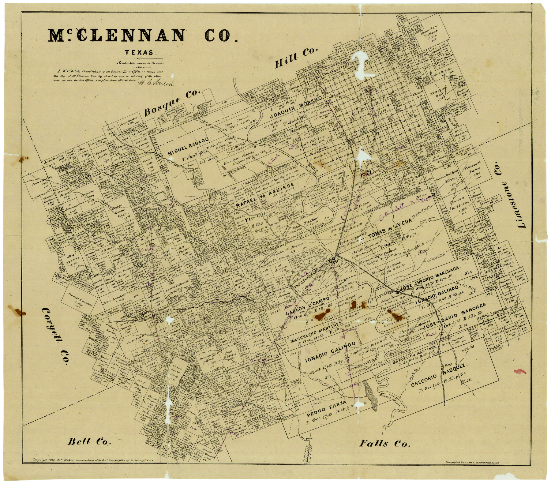
McClennan County
McLennan County Sketch File 39
-
Map/Doc
4597
-
Collection
General Map Collection
-
Object Dates
1880 (Creation Date)
-
People and Organizations
Texas General Land Office (Publisher)
W.C. Walsh (GLO Commissioner)
August Gast & Co. (Lithographer)
-
Counties
McLennan
-
Subjects
County
-
Height x Width
23.3 x 25.3 inches
59.2 x 64.3 cm
-
Scale
1" = 4000 varas
-
Comments
Note: "McLennan" misspelled on map as "McClennan".
Copyright 1880.
"Lithographed by A. Gast & Co's new process St. Louis."
Part of: General Map Collection
Kent County Working Sketch 9

Print $20.00
- Digital $50.00
Kent County Working Sketch 9
1953
Size 33.0 x 43.8 inches
Map/Doc 70016
Map of Callahan County

Print $20.00
- Digital $50.00
Map of Callahan County
1878
Size 23.0 x 18.8 inches
Map/Doc 3361
Schleicher County Working Sketch 21

Print $20.00
- Digital $50.00
Schleicher County Working Sketch 21
1953
Size 26.6 x 10.8 inches
Map/Doc 63823
Amistad International Reservoir on Rio Grande 65

Print $20.00
- Digital $50.00
Amistad International Reservoir on Rio Grande 65
1949
Size 28.2 x 39.8 inches
Map/Doc 73350
Kaufman County Boundary File 3

Print $14.00
- Digital $50.00
Kaufman County Boundary File 3
Size 12.7 x 8.2 inches
Map/Doc 55922
Flight Mission No. DAG-21K, Frame 131, Matagorda County

Print $20.00
- Digital $50.00
Flight Mission No. DAG-21K, Frame 131, Matagorda County
1952
Size 18.6 x 22.4 inches
Map/Doc 86457
Angelina County Sketch File 27

Print $10.00
- Digital $50.00
Angelina County Sketch File 27
1890
Size 14.1 x 8.7 inches
Map/Doc 13073
Harris County Rolled Sketch 69

Print $40.00
- Digital $50.00
Harris County Rolled Sketch 69
1941
Size 37.0 x 58.5 inches
Map/Doc 9131
Tyler County Sketch File 3a

Print $4.00
- Digital $50.00
Tyler County Sketch File 3a
1857
Size 6.2 x 8.2 inches
Map/Doc 38626
Tom Green County Sketch File 56

Print $20.00
- Digital $50.00
Tom Green County Sketch File 56
1883
Size 34.5 x 47.5 inches
Map/Doc 10404
Calhoun County Sketch File 6

Print $34.00
- Digital $50.00
Calhoun County Sketch File 6
1942
Size 9.3 x 9.0 inches
Map/Doc 35908
Trinity River, Boyd Crossing Sheet/Chambers Creek

Print $20.00
- Digital $50.00
Trinity River, Boyd Crossing Sheet/Chambers Creek
1931
Size 17.5 x 43.1 inches
Map/Doc 65238
You may also like
[Blocks 5-T, M-23, and vicinity]
![91230, [Blocks 5-T, M-23, and vicinity], Twichell Survey Records](https://historictexasmaps.com/wmedia_w700/maps/91230-1.tif.jpg)
Print $20.00
- Digital $50.00
[Blocks 5-T, M-23, and vicinity]
1890
Size 39.0 x 22.7 inches
Map/Doc 91230
Flight Mission No. DQN-1K, Frame 132, Calhoun County

Print $20.00
- Digital $50.00
Flight Mission No. DQN-1K, Frame 132, Calhoun County
1953
Size 18.4 x 22.1 inches
Map/Doc 84195
Flight Mission No. DCL-4C, Frame 120, Kenedy County

Print $20.00
- Digital $50.00
Flight Mission No. DCL-4C, Frame 120, Kenedy County
1943
Size 18.6 x 22.5 inches
Map/Doc 85819
Bandera County Sketch File 26

Print $6.00
- Digital $50.00
Bandera County Sketch File 26
1879
Size 7.7 x 8.3 inches
Map/Doc 14016
Zavala County Sketch File 33

Print $7.00
- Digital $50.00
Zavala County Sketch File 33
1886
Size 10.9 x 8.3 inches
Map/Doc 41392
Fannin County Sketch File 16

Print $4.00
- Digital $50.00
Fannin County Sketch File 16
1873
Size 8.1 x 10.3 inches
Map/Doc 22469
Crockett County Sketch File 58

Print $20.00
- Digital $50.00
Crockett County Sketch File 58
1932
Size 17.9 x 23.2 inches
Map/Doc 11226
Flight Mission No. CRC-5R, Frame 23, Chambers County

Print $20.00
- Digital $50.00
Flight Mission No. CRC-5R, Frame 23, Chambers County
1956
Size 18.8 x 22.4 inches
Map/Doc 84945
Culberson County Sketch File EM

Print $7.00
- Digital $50.00
Culberson County Sketch File EM
Size 36.2 x 40.3 inches
Map/Doc 10359
Montague County

Print $20.00
- Digital $50.00
Montague County
1924
Size 47.0 x 34.2 inches
Map/Doc 66938
Southern Part of Laguna Madre

Print $20.00
- Digital $50.00
Southern Part of Laguna Madre
1973
Size 44.2 x 35.2 inches
Map/Doc 73543
Travis County Appraisal District Plat Map 3_0721

Print $20.00
- Digital $50.00
Travis County Appraisal District Plat Map 3_0721
Size 21.5 x 26.3 inches
Map/Doc 94227