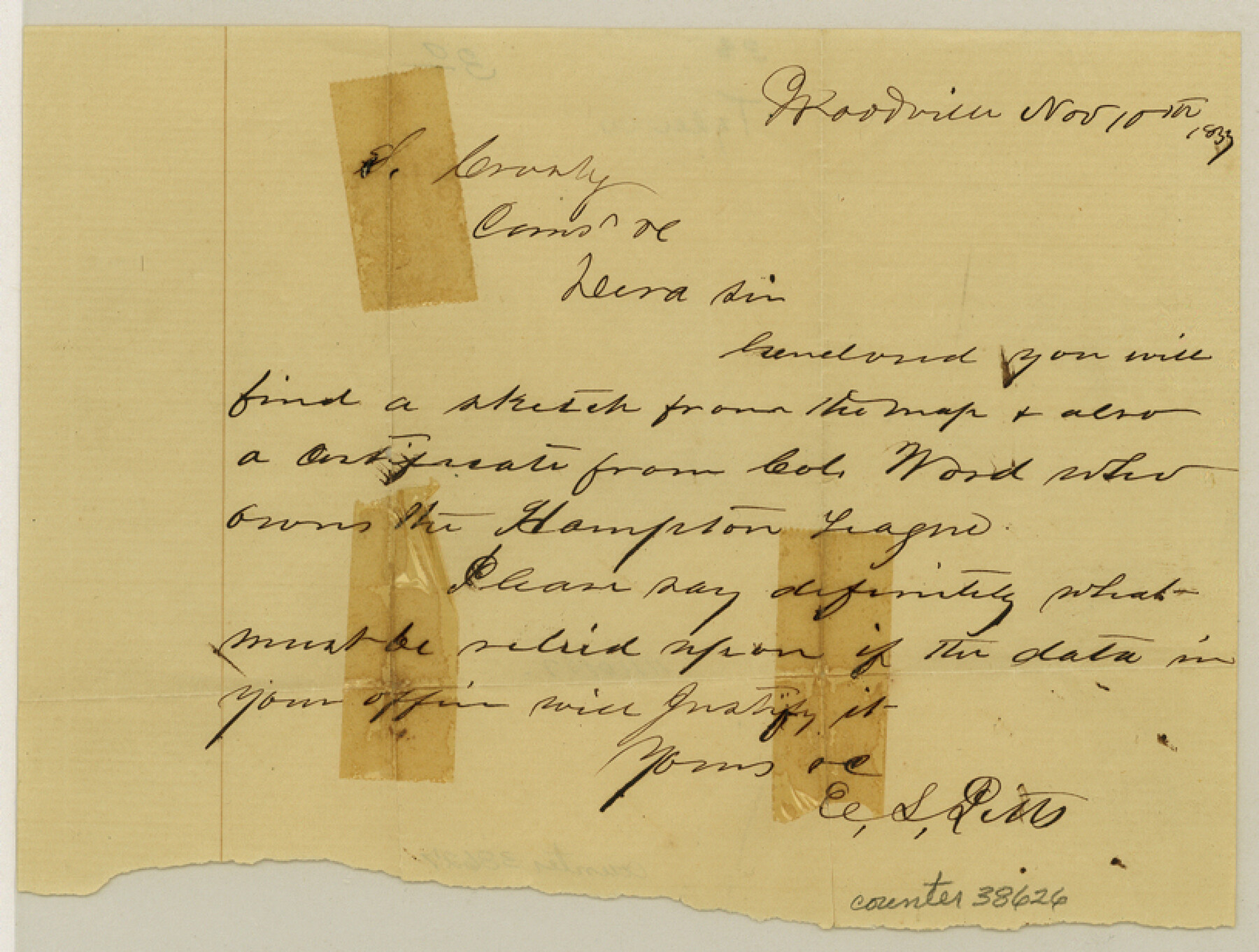
Tyler County Sketch File 3a
[Letter to the GLO regarding the Hampton League]
-
Map/Doc
38626
-
Collection
General Map Collection
-
Object Dates
11/10/1857 (Creation Date)
-
People and Organizations
E.L. Pitts (Author)
-
Counties
Tyler
-
Subjects
Surveying Sketch File
-
Height x Width
6.2 x 8.2 inches
15.8 x 20.8 cm
-
Medium
paper, manuscript
Part of: General Map Collection
Travis County Appraisal District Plat Map 1_0005

Print $20.00
- Digital $50.00
Travis County Appraisal District Plat Map 1_0005
Size 21.5 x 26.4 inches
Map/Doc 94204
Tom Green County Boundary File 1

Print $48.00
- Digital $50.00
Tom Green County Boundary File 1
Size 8.8 x 3.8 inches
Map/Doc 59329
[Map of Texas and Pacific Blocks from Brazos River westward through Palo Pinto, Stephens, Shackelford, Jones, Callahan, Taylor, Fisher, Nolan and Mitchell Counties]
![64510, [Map of Texas and Pacific Blocks from Brazos River westward through Palo Pinto, Stephens, Shackelford, Jones, Callahan, Taylor, Fisher, Nolan and Mitchell Counties], General Map Collection](https://historictexasmaps.com/wmedia_w700/maps/64510-1.tif.jpg)
Print $20.00
- Digital $50.00
[Map of Texas and Pacific Blocks from Brazos River westward through Palo Pinto, Stephens, Shackelford, Jones, Callahan, Taylor, Fisher, Nolan and Mitchell Counties]
Size 35.5 x 19.0 inches
Map/Doc 64510
Gray County Sketch File 12

Print $6.00
- Digital $50.00
Gray County Sketch File 12
1889
Size 17.0 x 8.3 inches
Map/Doc 24454

Potter County Sketch File 13

Print $20.00
- Digital $50.00
Potter County Sketch File 13
Size 21.6 x 16.6 inches
Map/Doc 12199
Flight Mission No. BRE-2P, Frame 108, Nueces County

Print $20.00
- Digital $50.00
Flight Mission No. BRE-2P, Frame 108, Nueces County
1956
Size 18.5 x 22.5 inches
Map/Doc 86793
Frank Lerch's Map of San Angelo and Additions

Print $20.00
- Digital $50.00
Frank Lerch's Map of San Angelo and Additions
1880
Size 36.6 x 26.3 inches
Map/Doc 2188
Blanco County Working Sketch 45

Print $20.00
- Digital $50.00
Blanco County Working Sketch 45
2007
Size 23.9 x 34.0 inches
Map/Doc 88609
Culberson County Sketch File 27a

Print $28.00
- Digital $50.00
Culberson County Sketch File 27a
Size 11.2 x 8.5 inches
Map/Doc 20266
Flight Mission No. DAG-21K, Frame 124, Matagorda County

Print $20.00
- Digital $50.00
Flight Mission No. DAG-21K, Frame 124, Matagorda County
1952
Size 18.5 x 22.4 inches
Map/Doc 86450
Right of Way and Track Map, Galveston, Harrisburg & San Antonio Ry. operated by the T. & N. O. R.R. Co., Victoria Division, Rosenberg to Beeville

Print $40.00
- Digital $50.00
Right of Way and Track Map, Galveston, Harrisburg & San Antonio Ry. operated by the T. & N. O. R.R. Co., Victoria Division, Rosenberg to Beeville
1918
Size 25.1 x 57.9 inches
Map/Doc 76157
You may also like
Henderson County Sketch File 13

Print $4.00
- Digital $50.00
Henderson County Sketch File 13
1876
Size 8.2 x 12.8 inches
Map/Doc 26353
Angelina County Sketch File 11c

Print $7.00
- Digital $50.00
Angelina County Sketch File 11c
Size 11.1 x 6.0 inches
Map/Doc 12946
Presidio County Sketch File 112

Print $166.00
- Digital $50.00
Presidio County Sketch File 112
1983
Size 12.1 x 31.2 inches
Map/Doc 11727
Childress County Working Sketch Graphic Index

Print $20.00
- Digital $50.00
Childress County Working Sketch Graphic Index
1978
Size 45.5 x 34.3 inches
Map/Doc 76493
[Leagues along West line of County]
![90547, [Leagues along West line of County], Twichell Survey Records](https://historictexasmaps.com/wmedia_w700/maps/90547-1.tif.jpg)
Print $2.00
- Digital $50.00
[Leagues along West line of County]
Size 5.7 x 11.6 inches
Map/Doc 90547
Andrews County Boundary File 2a

Print $14.00
- Digital $50.00
Andrews County Boundary File 2a
Size 11.2 x 8.9 inches
Map/Doc 49690
Missouri Pacific Railway System

Print $20.00
- Digital $50.00
Missouri Pacific Railway System
1888
Size 20.0 x 20.0 inches
Map/Doc 89223
Kent County Working Sketch 20

Print $40.00
- Digital $50.00
Kent County Working Sketch 20
1980
Size 50.7 x 44.1 inches
Map/Doc 70027
Flight Mission No. CRK-3P, Frame 177, Refugio County

Print $20.00
- Digital $50.00
Flight Mission No. CRK-3P, Frame 177, Refugio County
1956
Size 18.6 x 22.4 inches
Map/Doc 86924
El Paso County Rolled Sketch 62

Print $20.00
- Digital $50.00
El Paso County Rolled Sketch 62
Size 30.0 x 39.4 inches
Map/Doc 5854
Montgomery County Working Sketch 63

Print $20.00
- Digital $50.00
Montgomery County Working Sketch 63
1964
Size 31.6 x 36.7 inches
Map/Doc 71170
Chart of the Harbour of San [Luis]
![72763, Chart of the Harbour of San [Luis], General Map Collection](https://historictexasmaps.com/wmedia_w700/maps/72763.tif.jpg)
Print $20.00
- Digital $50.00
Chart of the Harbour of San [Luis]
1846
Size 27.7 x 18.3 inches
Map/Doc 72763