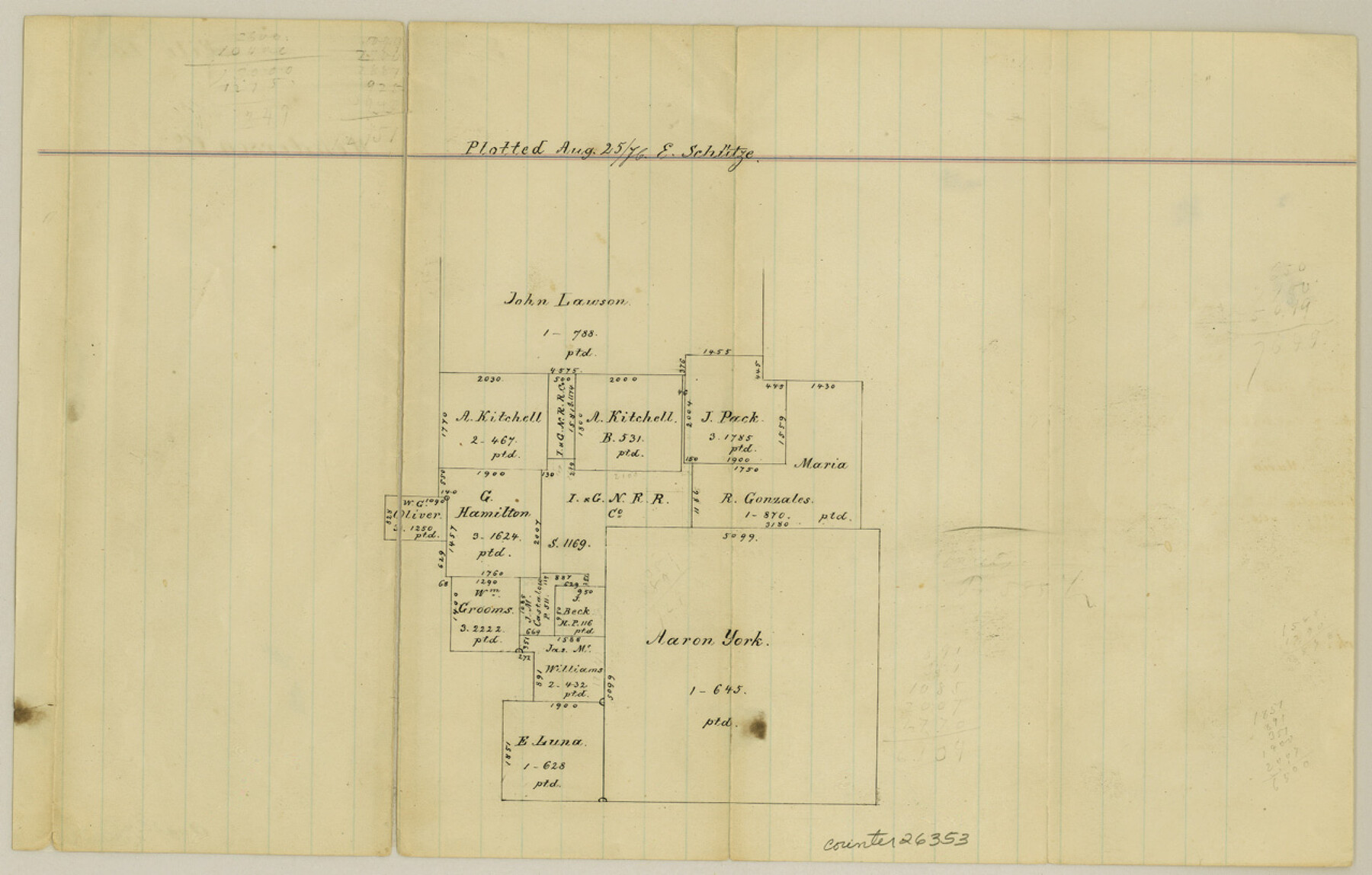
Henderson County Sketch File 13
[Sketch around Aaron York league and labor]
-
Map/Doc
26353
-
Collection
General Map Collection
-
Object Dates
8/25/1876 (Creation Date)
-
Counties
Henderson
-
Subjects
Surveying Sketch File
-
Height x Width
8.2 x 12.8 inches
20.8 x 32.5 cm
-
Medium
paper, manuscript
Part of: General Map Collection
Stonewall County Rolled Sketch 24A

Print $40.00
- Digital $50.00
Stonewall County Rolled Sketch 24A
1954
Size 55.0 x 47.1 inches
Map/Doc 9963
La Salle County Sketch File 23

Print $40.00
- Digital $50.00
La Salle County Sketch File 23
Size 14.2 x 17.3 inches
Map/Doc 29530
Kinney County Working Sketch 7

Print $20.00
- Digital $50.00
Kinney County Working Sketch 7
1908
Size 18.6 x 22.0 inches
Map/Doc 70189
Tarrant County Working Sketch 24

Print $20.00
- Digital $50.00
Tarrant County Working Sketch 24
2003
Size 26.0 x 34.9 inches
Map/Doc 78642
Wilbarger County Sketch File 11

Print $4.00
- Digital $50.00
Wilbarger County Sketch File 11
1885
Size 14.2 x 8.6 inches
Map/Doc 40183
Newton County Rolled Sketch 17

Print $20.00
- Digital $50.00
Newton County Rolled Sketch 17
1955
Size 34.5 x 47.1 inches
Map/Doc 6847
Flight Mission No. DAG-24K, Frame 54, Matagorda County

Print $20.00
- Digital $50.00
Flight Mission No. DAG-24K, Frame 54, Matagorda County
1953
Size 17.2 x 19.1 inches
Map/Doc 86541
Upton County Working Sketch 18

Print $20.00
- Digital $50.00
Upton County Working Sketch 18
1945
Size 19.7 x 19.9 inches
Map/Doc 69514
Erath County Sketch File 10

Print $4.00
- Digital $50.00
Erath County Sketch File 10
1871
Size 8.1 x 10.3 inches
Map/Doc 22275
Township 2 North Range 12 West, North Western District, Louisiana

Print $20.00
- Digital $50.00
Township 2 North Range 12 West, North Western District, Louisiana
1884
Size 19.6 x 24.7 inches
Map/Doc 65875
Kimble County Sketch File 10

Print $23.00
- Digital $50.00
Kimble County Sketch File 10
Size 18.5 x 15.6 inches
Map/Doc 28931
New Map of Greater San Antonio

Print $20.00
- Digital $50.00
New Map of Greater San Antonio
1941
Size 24.5 x 19.7 inches
Map/Doc 95954
You may also like
Brazoria County Rolled Sketch 42

Print $20.00
- Digital $50.00
Brazoria County Rolled Sketch 42
1962
Size 35.0 x 44.5 inches
Map/Doc 8461
Map of Brazoria County

Print $20.00
- Digital $50.00
Map of Brazoria County
1918
Size 26.1 x 22.6 inches
Map/Doc 1518
Harrison County Working Sketch 13

Print $20.00
- Digital $50.00
Harrison County Working Sketch 13
1961
Size 32.4 x 37.0 inches
Map/Doc 66033
Liberty County Sketch File 37

Print $15.00
- Digital $50.00
Liberty County Sketch File 37
1895
Size 14.9 x 10.0 inches
Map/Doc 29976
Nacogdoches County Sketch File 17

Print $2.00
- Digital $50.00
Nacogdoches County Sketch File 17
1867
Size 15.4 x 8.7 inches
Map/Doc 32267
Coleman County

Print $40.00
- Digital $50.00
Coleman County
1945
Size 54.7 x 37.1 inches
Map/Doc 73109
Cienega Ranch

Print $20.00
- Digital $50.00
Cienega Ranch
1947
Size 17.5 x 17.1 inches
Map/Doc 92287
Presidio County Working Sketch 11

Print $20.00
- Digital $50.00
Presidio County Working Sketch 11
1941
Size 29.2 x 25.8 inches
Map/Doc 71686
Crockett County Rolled Sketch 62

Print $20.00
- Digital $50.00
Crockett County Rolled Sketch 62
1947
Size 27.0 x 38.1 inches
Map/Doc 5605
Harris County Sketch File C

Print $4.00
- Digital $50.00
Harris County Sketch File C
1866
Size 5.9 x 9.8 inches
Map/Doc 25311
[Township 3 North, Block 32]
![91218, [Township 3 North, Block 32], Twichell Survey Records](https://historictexasmaps.com/wmedia_w700/maps/91218-1.tif.jpg)
Print $20.00
- Digital $50.00
[Township 3 North, Block 32]
Size 14.4 x 17.8 inches
Map/Doc 91218
Working Sketch Hale County

Print $20.00
- Digital $50.00
Working Sketch Hale County
1909
Size 17.9 x 20.9 inches
Map/Doc 90745