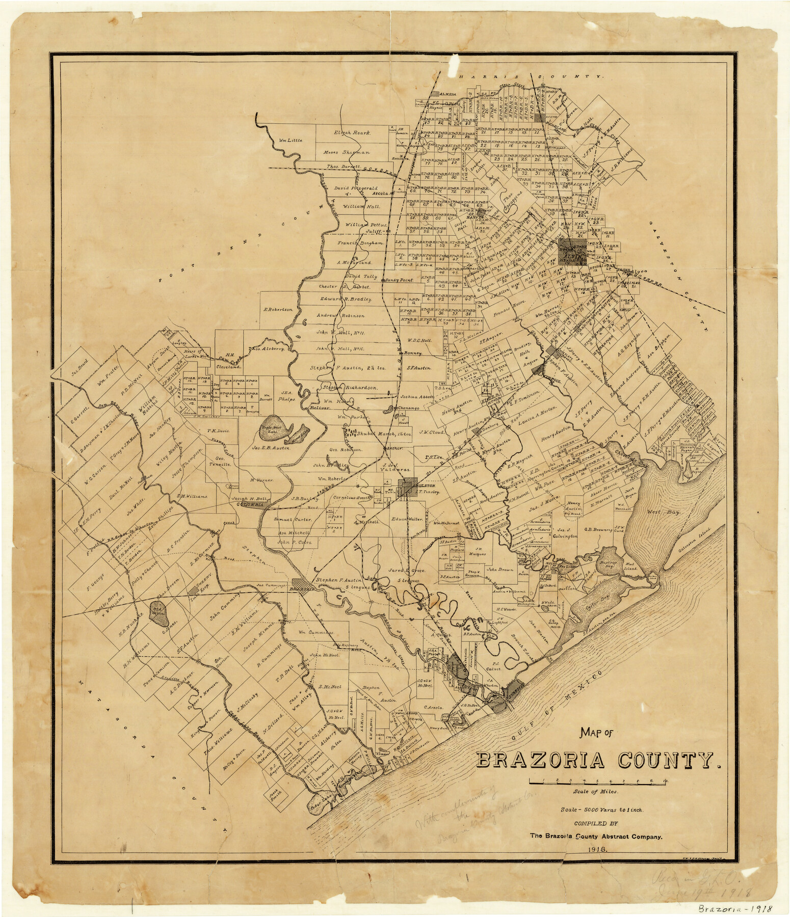
Map of Brazoria County
-
Map/Doc
1518
-
Collection
General Map Collection
-
Object Dates
1918 (Creation Date)
-
People and Organizations
The Brazoria County Abstract Company (Publisher)
Brazoria County Abstract Company (Compiler)
P.W. Stevens (Draftsman)
F.K. Stevens (Draftsman)
-
Counties
Brazoria
-
Subjects
County
-
Height x Width
26.1 x 22.6 inches
66.3 x 57.4 cm
-
Comments
Received in General Land Office June 19, 1918 with compliments of the Brazoria County Abstract Company.
-
Features
Blacks Road Ferry
Gravel Road
H&BV
Clute
Brazos River
LJRR
Brazoria
Overlong's Ferry
Sweeny
Old Orsaka [Lake]
Railroad Grade to Wharton
Big Slough
Lutors Creek
Blacks Road
Rice Canals
Cox Lake
Bastrop Bayou
Bastrop Bay
Mud Island
Galveston Island
West Bay
Freeport
Clear Lake
Gulf of Mexico
Barrows [Lake]
Churchills [Ferry]
Cedar Lake Bayou
Linnville Bayou
Mirrons Bridge
Hindles Ferry
Jones Creek
Chocolate Bay
Bryan Heights
Quintana
West Union Bayou
Surfside
Oyster Bay Canal
San Luis Pass
San Luis Island
Bastrop Bay
Oyster Bay
Juliff
Halls Bayou
Mustang Slough
Liverpool
Chocolate Bayou
I&GN
Cow Creek
Airline Road
Dolores
Algoa
Danbury
Manvel
Arcola
GC&SF
Oyster Creek
Alvin
Sandy Point
Brazos River
Pearland
Clear Creek
Mound Creek
Big Mound
Austin's Bayou
Brushy Bayou
SLB&M
Angleton
Long Pond
Kaiser Mound
Underwood's [house]
San Bernard River
Almeda
Varner's Creek
Manor Lake
Eagle Nest Lake
Bolivar
Jennings Bayou
TSR
Anchor
Chenango
Flores Bayou
Part of: General Map Collection
Stonewall County Rolled Sketch 18

Print $20.00
- Digital $50.00
Stonewall County Rolled Sketch 18
1950
Size 27.4 x 29.4 inches
Map/Doc 7872
Briscoe County Sketch File F

Print $40.00
- Digital $50.00
Briscoe County Sketch File F
1917
Size 20.9 x 19.3 inches
Map/Doc 76756
Galveston Harbor and Channel, Texas - Rehabilitation of Galveston Groins - Location Plan of Rehabilitation

Print $4.00
- Digital $50.00
Galveston Harbor and Channel, Texas - Rehabilitation of Galveston Groins - Location Plan of Rehabilitation
1968
Size 16.0 x 20.6 inches
Map/Doc 73620
Archer County Working Sketch 21

Print $20.00
- Digital $50.00
Archer County Working Sketch 21
1976
Size 18.2 x 27.4 inches
Map/Doc 67162
Randall County Sketch File 7

Print $14.00
- Digital $50.00
Randall County Sketch File 7
1931
Size 7.3 x 8.9 inches
Map/Doc 34963

Leon County Working Sketch 4

Print $20.00
- Digital $50.00
Leon County Working Sketch 4
Size 18.1 x 14.0 inches
Map/Doc 70403
Hudspeth County Rolled Sketch 65

Print $40.00
- Digital $50.00
Hudspeth County Rolled Sketch 65
1988
Size 70.5 x 37.7 inches
Map/Doc 9229
Frio County Rolled Sketch 5

Print $20.00
- Digital $50.00
Frio County Rolled Sketch 5
Size 25.7 x 23.0 inches
Map/Doc 5917
Kimble County Working Sketch 7

Print $20.00
- Digital $50.00
Kimble County Working Sketch 7
1917
Size 12.6 x 16.8 inches
Map/Doc 70075
Jasper County Sketch File 25

Print $16.00
- Digital $50.00
Jasper County Sketch File 25
1941
Size 14.2 x 8.7 inches
Map/Doc 27826
King County Sketch File 11

Print $40.00
- Digital $50.00
King County Sketch File 11
1902
Size 13.7 x 9.1 inches
Map/Doc 29085
You may also like
[Sketch showing Blocks B-11, O-18, P and Mc in case of Laneer vs. Bivens]
![91727, [Sketch showing Blocks B-11, O-18, P and Mc in case of Laneer vs. Bivens], Twichell Survey Records](https://historictexasmaps.com/wmedia_w700/maps/91727-1.tif.jpg)
Print $20.00
- Digital $50.00
[Sketch showing Blocks B-11, O-18, P and Mc in case of Laneer vs. Bivens]
Size 20.9 x 18.9 inches
Map/Doc 91727

Upshur County Working Sketch 4

Print $20.00
- Digital $50.00
Upshur County Working Sketch 4
1939
Size 21.6 x 15.3 inches
Map/Doc 69560
Schleicher County Rolled Sketch 15

Print $20.00
- Digital $50.00
Schleicher County Rolled Sketch 15
Size 28.8 x 41.0 inches
Map/Doc 7757
Crockett County Working Sketch 69

Print $20.00
- Digital $50.00
Crockett County Working Sketch 69
1962
Size 34.8 x 45.5 inches
Map/Doc 68402
Flight Mission No. BRA-16M, Frame 84, Jefferson County

Print $20.00
- Digital $50.00
Flight Mission No. BRA-16M, Frame 84, Jefferson County
1953
Size 18.6 x 22.1 inches
Map/Doc 85696
Guadalupe County Working Sketch 12

Print $20.00
- Digital $50.00
Guadalupe County Working Sketch 12
2005
Size 29.1 x 23.5 inches
Map/Doc 83571
Kinney County Working Sketch 2

Print $20.00
- Digital $50.00
Kinney County Working Sketch 2
1886
Size 20.0 x 20.4 inches
Map/Doc 70184
Matagorda County Aerial Photograph Index Sheet 8

Print $20.00
- Digital $50.00
Matagorda County Aerial Photograph Index Sheet 8
1953
Size 19.6 x 23.8 inches
Map/Doc 83729
General Highway Map, Jones County, Texas

Print $20.00
General Highway Map, Jones County, Texas
1940
Size 18.5 x 24.8 inches
Map/Doc 79150
Atascosa County Rolled Sketch 16

Print $20.00
- Digital $50.00
Atascosa County Rolled Sketch 16
1952
Size 22.7 x 38.3 inches
Map/Doc 5096
Montague County Sketch File 27

Print $20.00
- Digital $50.00
Montague County Sketch File 27
1954
Size 15.8 x 22.5 inches
Map/Doc 12109