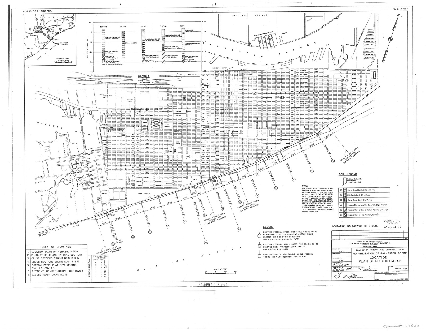
Galveston Harbor and Channel, Texas - Rehabilitation of Galveston Groins - Location Plan of Rehabilitation
Galveston Miscellaneous 11
-
Map/Doc
73620
-
Collection
General Map Collection
-
Object Dates
3/1968 (Creation Date)
-
People and Organizations
U. S. Army Engineer District, Galveston (Publisher)
-
Counties
Galveston
-
Subjects
City
-
Height x Width
16.0 x 20.6 inches
40.6 x 52.3 cm
-
Comments
Xerox copy
Part of: General Map Collection
Brewster County Rolled Sketch 135

Print $20.00
- Digital $50.00
Brewster County Rolled Sketch 135
Size 43.1 x 41.5 inches
Map/Doc 8525
Lavaca County Working Sketch 1

Print $20.00
- Digital $50.00
Lavaca County Working Sketch 1
1905
Size 18.0 x 22.5 inches
Map/Doc 70354
Map of Fort Bend Co.

Print $20.00
- Digital $50.00
Map of Fort Bend Co.
1898
Size 45.1 x 41.1 inches
Map/Doc 75965
Schleicher County Rolled Sketch 20

Print $20.00
- Digital $50.00
Schleicher County Rolled Sketch 20
1958
Size 35.5 x 20.0 inches
Map/Doc 9906
Donley County Sketch File 9

Print $4.00
- Digital $50.00
Donley County Sketch File 9
1884
Size 6.6 x 7.7 inches
Map/Doc 21238
Tyler County Rolled Sketch 11

Print $20.00
- Digital $50.00
Tyler County Rolled Sketch 11
Size 34.2 x 36.4 inches
Map/Doc 10033
Texas Official Highway Travel Map

Digital $50.00
Texas Official Highway Travel Map
Size 27.1 x 36.2 inches
Map/Doc 94311
Lipscomb County Boundary File 14

Print $62.00
- Digital $50.00
Lipscomb County Boundary File 14
Size 13.3 x 8.8 inches
Map/Doc 56355
Harris County Working Sketch 50

Print $20.00
- Digital $50.00
Harris County Working Sketch 50
1947
Size 38.7 x 35.6 inches
Map/Doc 65942
Upshur County Sketch File 17

Print $62.00
- Digital $50.00
Upshur County Sketch File 17
1965
Size 35.4 x 31.8 inches
Map/Doc 10410
Harris County Sketch File 105

Print $28.00
- Digital $50.00
Harris County Sketch File 105
1925
Size 11.2 x 9.0 inches
Map/Doc 42929
Map of Chicago, Rock Island & Texas Railway through Montague and Wise Counties, Texas

Print $20.00
- Digital $50.00
Map of Chicago, Rock Island & Texas Railway through Montague and Wise Counties, Texas
1893
Size 19.0 x 47.6 inches
Map/Doc 64469
You may also like
The Republic County of Fayette. January 29, 1842

Print $20.00
The Republic County of Fayette. January 29, 1842
2020
Size 14.7 x 21.7 inches
Map/Doc 96134
Township 2 North, Block 32]
![91211, Township 2 North, Block 32], Twichell Survey Records](https://historictexasmaps.com/wmedia_w700/maps/91211-1.tif.jpg)
Print $2.00
- Digital $50.00
Township 2 North, Block 32]
Size 9.0 x 13.7 inches
Map/Doc 91211
Webb County Sketch File 50-1

Print $8.00
- Digital $50.00
Webb County Sketch File 50-1
1943
Size 14.5 x 8.9 inches
Map/Doc 39833
La Salle County Sketch File 10

Print $4.00
- Digital $50.00
La Salle County Sketch File 10
1877
Size 9.0 x 7.0 inches
Map/Doc 42997
Castro County Sketch File 4d

Print $4.00
- Digital $50.00
Castro County Sketch File 4d
Size 13.6 x 8.8 inches
Map/Doc 17471
Flight Mission No. CGI-1N, Frame 173, Cameron County

Print $20.00
- Digital $50.00
Flight Mission No. CGI-1N, Frame 173, Cameron County
1955
Size 18.5 x 22.1 inches
Map/Doc 84508
Dawson County Rolled Sketch 13

Print $20.00
- Digital $50.00
Dawson County Rolled Sketch 13
1951
Size 18.9 x 25.4 inches
Map/Doc 5696
Crockett County Working Sketch 59

Print $20.00
- Digital $50.00
Crockett County Working Sketch 59
1955
Size 46.1 x 29.3 inches
Map/Doc 68392
Red River County Working Sketch 11

Print $20.00
- Digital $50.00
Red River County Working Sketch 11
1935
Size 19.4 x 24.6 inches
Map/Doc 71994
Fort Bend County State Real Property Sketch 18

Print $40.00
- Digital $50.00
Fort Bend County State Real Property Sketch 18
2006
Size 17.7 x 24.0 inches
Map/Doc 88615
Nova Totivs Americae Descriptio

Print $20.00
- Digital $50.00
Nova Totivs Americae Descriptio
1666
Size 21.2 x 24.3 inches
Map/Doc 93818
Henderson County Working Sketch 44

Print $20.00
- Digital $50.00
Henderson County Working Sketch 44
1998
Size 19.0 x 33.0 inches
Map/Doc 66177