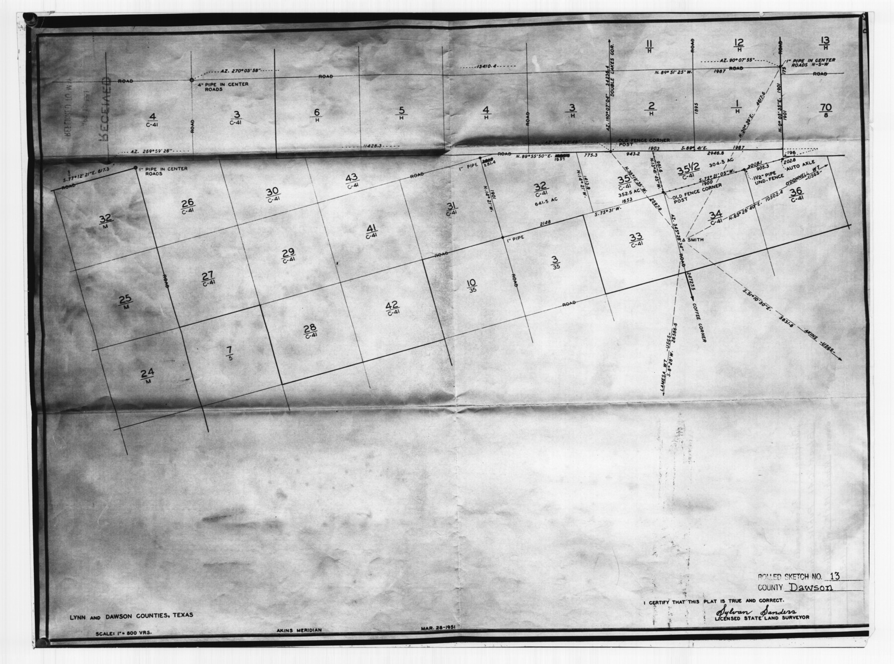
Dawson County Rolled Sketch 13
[Sketch of portion of Block C-41]
-
Map/Doc
5696
-
Collection
General Map Collection
-
Object Dates
1951/3/28 (Creation Date)
1974/1/31 (File Date)
-
People and Organizations
Sylvan Sanders (Surveyor/Engineer)
-
Counties
Dawson
-
Subjects
Surveying Rolled Sketch
-
Height x Width
18.9 x 25.4 inches
48.0 x 64.5 cm
-
Medium
photostat
-
Scale
1" = 800 varas
Part of: General Map Collection
Schleicher County Sketch File 37

Print $20.00
- Digital $50.00
Schleicher County Sketch File 37
1952
Size 24.9 x 29.3 inches
Map/Doc 12310
Robertson County Working Sketch 7

Print $20.00
- Digital $50.00
Robertson County Working Sketch 7
1983
Size 36.4 x 38.5 inches
Map/Doc 63580
Stephens County Working Sketch 1

Print $20.00
- Digital $50.00
Stephens County Working Sketch 1
Size 13.5 x 16.1 inches
Map/Doc 63944
Map of Corpus Christi Bay in Nueces County Showing Subdivision for Mineral Development

Print $40.00
- Digital $50.00
Map of Corpus Christi Bay in Nueces County Showing Subdivision for Mineral Development
1950
Size 49.3 x 37.2 inches
Map/Doc 3129
Galveston County Sketch File 28

Print $42.00
- Digital $50.00
Galveston County Sketch File 28
1913
Size 22.2 x 5.4 inches
Map/Doc 23410
Willacy County

Print $20.00
- Digital $50.00
Willacy County
1921
Size 25.2 x 32.2 inches
Map/Doc 73325
[Geological Map of Texas]
![62962, [Geological Map of Texas], General Map Collection](https://historictexasmaps.com/wmedia_w700/maps/62962.tif.jpg)
Print $20.00
- Digital $50.00
[Geological Map of Texas]
Size 17.6 x 18.1 inches
Map/Doc 62962
Gillespie County Sketch File 9

Print $4.00
- Digital $50.00
Gillespie County Sketch File 9
1873
Size 8.2 x 10.5 inches
Map/Doc 24145
Harris County Working Sketch 93

Print $20.00
- Digital $50.00
Harris County Working Sketch 93
1977
Size 25.9 x 21.1 inches
Map/Doc 65985
Ward County Working Sketch 51

Print $40.00
- Digital $50.00
Ward County Working Sketch 51
1980
Size 34.4 x 52.1 inches
Map/Doc 72357
La Salle County Rolled Sketch 33

Print $20.00
- Digital $50.00
La Salle County Rolled Sketch 33
2015
Size 17.6 x 27.6 inches
Map/Doc 95306
Jefferson County Rolled Sketch 37

Print $20.00
- Digital $50.00
Jefferson County Rolled Sketch 37
1957
Size 36.4 x 30.1 inches
Map/Doc 6396
You may also like
[Andrews County Road Map]
![92453, [Andrews County Road Map], Twichell Survey Records](https://historictexasmaps.com/wmedia_w700/maps/92453-1.tif.jpg)
Print $20.00
- Digital $50.00
[Andrews County Road Map]
1951
Size 18.6 x 25.6 inches
Map/Doc 92453
Map of Kendall County

Print $20.00
- Digital $50.00
Map of Kendall County
1899
Size 36.8 x 34.2 inches
Map/Doc 66887
Map of Blue Creek Ranch in Moore County, Texas

Print $20.00
- Digital $50.00
Map of Blue Creek Ranch in Moore County, Texas
Size 15.1 x 13.8 inches
Map/Doc 91420
Calhoun County Working Sketch 3

Print $20.00
- Digital $50.00
Calhoun County Working Sketch 3
1923
Size 18.4 x 42.4 inches
Map/Doc 67819
Anderson County Sketch File 7

Print $4.00
- Digital $50.00
Anderson County Sketch File 7
Size 7.9 x 10.0 inches
Map/Doc 12757
Presidio County Working Sketch 78

Print $20.00
- Digital $50.00
Presidio County Working Sketch 78
1965
Size 24.8 x 25.1 inches
Map/Doc 71755
Galveston County Rolled Sketch JS

Print $20.00
- Digital $50.00
Galveston County Rolled Sketch JS
1934
Size 34.0 x 41.9 inches
Map/Doc 9091
Hidalgo County Rolled Sketch 12

Print $20.00
- Digital $50.00
Hidalgo County Rolled Sketch 12
1908
Size 21.3 x 27.9 inches
Map/Doc 6211
Calhoun County Rolled Sketch 6

Print $20.00
- Digital $50.00
Calhoun County Rolled Sketch 6
Size 24.0 x 22.5 inches
Map/Doc 5362
Texas Gulf Coast, from the Sabine River to the Rio Grande as Subdivided for Mineral Development; Matagorda, Calhoun and Aransas Counties

Print $40.00
- Digital $50.00
Texas Gulf Coast, from the Sabine River to the Rio Grande as Subdivided for Mineral Development; Matagorda, Calhoun and Aransas Counties
1976
Size 43.0 x 90.9 inches
Map/Doc 1939
Starr County Sketch File 10

Print $40.00
- Digital $50.00
Starr County Sketch File 10
Size 12.6 x 15.0 inches
Map/Doc 36863
In the Supreme Court of the United States, The State of Oklahoma, Complainant vs. The State of Texas, Defendant, The United States of America, Intervener, Red River Valley, Texas and Oklahoma Between the 98th and 100th Meridians in Five Sheets, 1921

Print $40.00
- Digital $50.00
In the Supreme Court of the United States, The State of Oklahoma, Complainant vs. The State of Texas, Defendant, The United States of America, Intervener, Red River Valley, Texas and Oklahoma Between the 98th and 100th Meridians in Five Sheets, 1921
1921
Size 38.4 x 60.0 inches
Map/Doc 75275