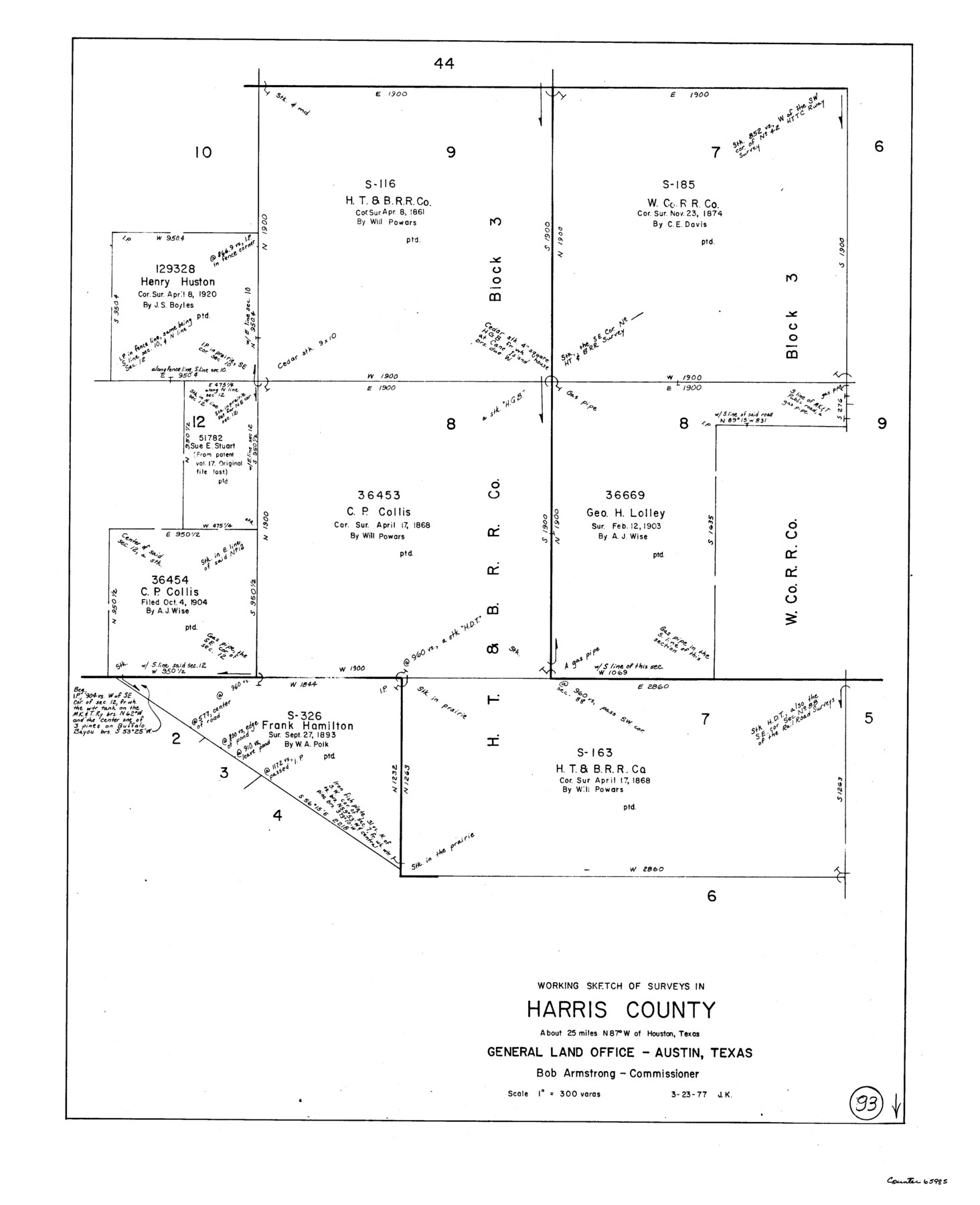
Harris County Working Sketch 93
-
Map/Doc
65985
-
Collection
General Map Collection
-
Object Dates
3/23/1977 (Creation Date)
-
People and Organizations
Joan Kilpatrick (Draftsman)
-
Counties
Harris
-
Subjects
Surveying Working Sketch
-
Height x Width
25.9 x 21.1 inches
65.8 x 53.6 cm
-
Scale
1" = 300 varas
Part of: General Map Collection
Mapa del Rio Grande desde su Desembocadura en el Golfo hasta San Vicente, Presidio Antíguo

Print $20.00
- Digital $50.00
Mapa del Rio Grande desde su Desembocadura en el Golfo hasta San Vicente, Presidio Antíguo
1873
Size 38.1 x 32.3 inches
Map/Doc 97126
Flight Mission No. BQR-5K, Frame 72, Brazoria County

Print $20.00
- Digital $50.00
Flight Mission No. BQR-5K, Frame 72, Brazoria County
1952
Size 18.9 x 22.4 inches
Map/Doc 84017
Matagorda County Rolled Sketch 16

Print $20.00
- Digital $50.00
Matagorda County Rolled Sketch 16
Size 25.7 x 41.6 inches
Map/Doc 7591
Kleberg County Aerial Photograph Index Sheet 3

Print $20.00
- Digital $50.00
Kleberg County Aerial Photograph Index Sheet 3
1956
Size 19.1 x 23.4 inches
Map/Doc 83720
Marion County Working Sketch 9

Print $20.00
- Digital $50.00
Marion County Working Sketch 9
1940
Size 23.5 x 25.5 inches
Map/Doc 70784
Montgomery County Rolled Sketch 42

Print $20.00
- Digital $50.00
Montgomery County Rolled Sketch 42
1939
Size 13.9 x 20.1 inches
Map/Doc 6819
Matagorda County Sketch File 15

Print $48.00
- Digital $50.00
Matagorda County Sketch File 15
Size 8.7 x 11.2 inches
Map/Doc 30774
Map of Surveys Made for the T&PRRCo in Howard, Mitchell & Tom Green Counties, Blocks 27, 28, 29, 30, 31, 32 & 33, Reserve West of the Colorado

Print $40.00
- Digital $50.00
Map of Surveys Made for the T&PRRCo in Howard, Mitchell & Tom Green Counties, Blocks 27, 28, 29, 30, 31, 32 & 33, Reserve West of the Colorado
1876
Size 42.0 x 51.0 inches
Map/Doc 2228
Jasper County Sketch File 21

Print $4.00
- Digital $50.00
Jasper County Sketch File 21
Size 13.4 x 8.9 inches
Map/Doc 27820
Baylor County Sketch File 16

Print $6.00
- Digital $50.00
Baylor County Sketch File 16
1879
Size 9.5 x 6.2 inches
Map/Doc 14186
Freestone County Working Sketch 23

Print $20.00
- Digital $50.00
Freestone County Working Sketch 23
1982
Size 20.1 x 17.0 inches
Map/Doc 69265
Brazoria County Working Sketch 17

Print $20.00
- Digital $50.00
Brazoria County Working Sketch 17
1948
Size 17.0 x 19.0 inches
Map/Doc 67502
You may also like
Flight Mission No. CRK-7P, Frame 28, Refugio County

Print $20.00
- Digital $50.00
Flight Mission No. CRK-7P, Frame 28, Refugio County
1956
Size 18.4 x 22.1 inches
Map/Doc 86948
General Highway Map, Wilson County, Texas

Print $20.00
General Highway Map, Wilson County, Texas
1961
Size 18.0 x 24.6 inches
Map/Doc 79715
Township No. 4 South Range No. 19 West of the Indian Meridian

Print $20.00
- Digital $50.00
Township No. 4 South Range No. 19 West of the Indian Meridian
1875
Size 19.1 x 24.5 inches
Map/Doc 75183
Foard County Working Sketch 8

Print $40.00
- Digital $50.00
Foard County Working Sketch 8
1975
Size 57.0 x 40.0 inches
Map/Doc 69199
Morris County Rolled Sketch 2A

Print $20.00
- Digital $50.00
Morris County Rolled Sketch 2A
Size 24.1 x 18.9 inches
Map/Doc 10278
Robertson County Sketch File 5 1/2

Print $2.00
- Digital $50.00
Robertson County Sketch File 5 1/2
Size 8.1 x 4.2 inches
Map/Doc 35361
Pecos County Sketch File 31

Print $20.00
- Digital $50.00
Pecos County Sketch File 31
1931
Size 14.3 x 32.4 inches
Map/Doc 12173
Howard T. Trigg's Official Map of Amarillo

Print $40.00
- Digital $50.00
Howard T. Trigg's Official Map of Amarillo
Size 79.1 x 54.0 inches
Map/Doc 93196
Williamson County Working Sketch 8

Print $20.00
- Digital $50.00
Williamson County Working Sketch 8
1950
Size 43.4 x 25.4 inches
Map/Doc 72568
Amistad International Reservoir on Rio Grande 91

Print $20.00
- Digital $50.00
Amistad International Reservoir on Rio Grande 91
1950
Size 28.5 x 41.0 inches
Map/Doc 75521
Cottle County Sketch File 7 1/2

Print $26.00
- Digital $50.00
Cottle County Sketch File 7 1/2
1889
Size 40.2 x 21.0 inches
Map/Doc 10342
