Morris County Rolled Sketch 2A
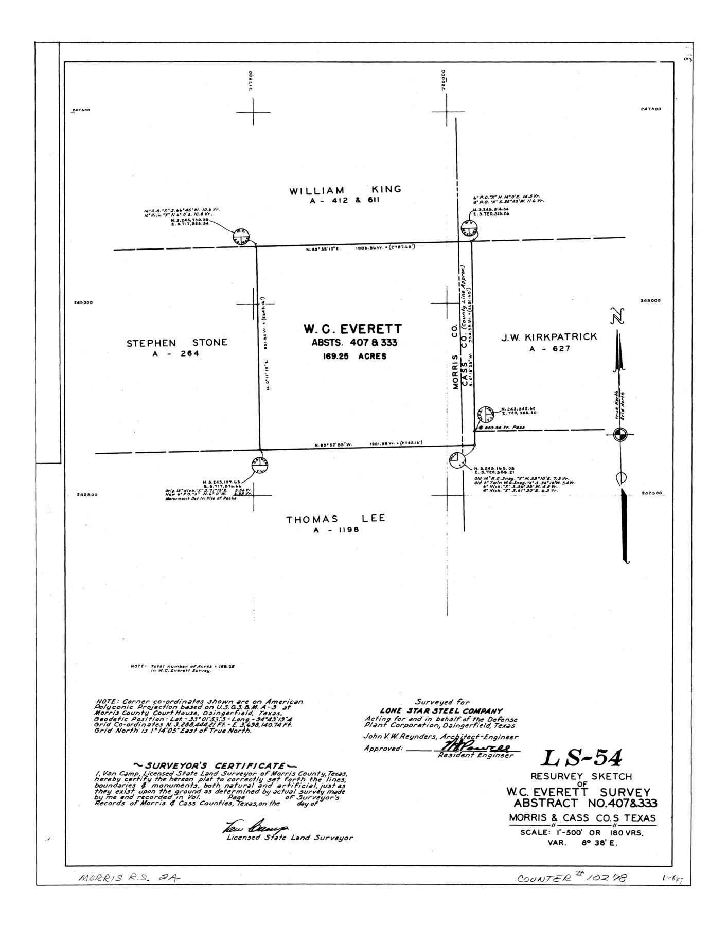
LS-54 - Resurvey sketch of W.C. Everett survey, abstract no. 407 & 333, Morris & Cass Cos., Texas
-
Map/Doc
10278
-
Collection
General Map Collection
-
People and Organizations
Van Camp (Surveyor/Engineer)
-
Counties
Morris Cass
-
Subjects
Surveying Rolled Sketch
-
Height x Width
24.1 x 18.9 inches
61.2 x 48.0 cm
-
Medium
linen, manuscript
-
Scale
1" = 180 varas
-
Comments
See Morris County Rolled Sketch 2 (9550) for map of all retracement surveys made for Lone Star Steel Company.
Related maps
Morris County Rolled Sketch 2

Print $40.00
- Digital $50.00
Morris County Rolled Sketch 2
1944
Size 59.4 x 43.5 inches
Map/Doc 9550
Part of: General Map Collection
Tyler County Sketch File 7

Print $4.00
- Digital $50.00
Tyler County Sketch File 7
1874
Size 13.4 x 7.7 inches
Map/Doc 38637
Bell County Sketch File 30

Print $4.00
- Digital $50.00
Bell County Sketch File 30
1876
Size 10.1 x 8.0 inches
Map/Doc 14443
Hockley County Boundary File 6

Print $446.00
- Digital $50.00
Hockley County Boundary File 6
Size 3.1 x 5.1 inches
Map/Doc 54832
Gregg County Working Sketch 24

Print $20.00
- Digital $50.00
Gregg County Working Sketch 24
1985
Size 26.6 x 16.3 inches
Map/Doc 63291
Lipscomb County Working Sketch 5

Print $20.00
- Digital $50.00
Lipscomb County Working Sketch 5
1977
Size 26.8 x 30.0 inches
Map/Doc 70581
Flight Mission No. BRA-7M, Frame 202, Jefferson County

Print $20.00
- Digital $50.00
Flight Mission No. BRA-7M, Frame 202, Jefferson County
1953
Size 18.6 x 22.3 inches
Map/Doc 85570
A Map of the Cotton Kingdom and its Dependencies in America

Print $20.00
- Digital $50.00
A Map of the Cotton Kingdom and its Dependencies in America
1861
Size 12.2 x 18.6 inches
Map/Doc 96573
Uvalde County Sketch File 10

Print $6.00
- Digital $50.00
Uvalde County Sketch File 10
1886
Size 9.2 x 6.1 inches
Map/Doc 38969
Flight Mission No. DQN-1K, Frame 143, Calhoun County

Print $20.00
- Digital $50.00
Flight Mission No. DQN-1K, Frame 143, Calhoun County
1953
Size 18.5 x 22.1 inches
Map/Doc 84206
Harris County Rolled Sketch 91

Print $407.00
- Digital $50.00
Harris County Rolled Sketch 91
1981
Size 31.0 x 24.3 inches
Map/Doc 6130
Colorado County Working Sketch Graphic Index

Print $40.00
- Digital $50.00
Colorado County Working Sketch Graphic Index
1946
Size 52.7 x 42.4 inches
Map/Doc 76500
Loving County Working Sketch 9

Print $20.00
- Digital $50.00
Loving County Working Sketch 9
1952
Size 24.8 x 45.8 inches
Map/Doc 70641
You may also like
Panola County Sketch File 13

Print $4.00
- Digital $50.00
Panola County Sketch File 13
1850
Size 14.1 x 7.8 inches
Map/Doc 33470
The Texas and Pacific Ry. Co., Station Map, Iatan, Mitchell County, Texas

Print $20.00
- Digital $50.00
The Texas and Pacific Ry. Co., Station Map, Iatan, Mitchell County, Texas
1929
Size 11.0 x 18.4 inches
Map/Doc 64667
Van Zandt County Sketch File 15a

Print $4.00
- Digital $50.00
Van Zandt County Sketch File 15a
1858
Size 6.7 x 8.1 inches
Map/Doc 39406
Gray's Geological Map of the United States

Print $20.00
- Digital $50.00
Gray's Geological Map of the United States
1873
Size 17.6 x 28.8 inches
Map/Doc 95174
Howard County Working Sketch 7b

Print $40.00
- Digital $50.00
Howard County Working Sketch 7b
1950
Size 83.3 x 25.6 inches
Map/Doc 66274
Brazos River, Brazos River Sheet 7

Print $20.00
- Digital $50.00
Brazos River, Brazos River Sheet 7
1926
Size 22.8 x 27.8 inches
Map/Doc 69671
Liberty County Working Sketch 34

Print $20.00
- Digital $50.00
Liberty County Working Sketch 34
1946
Size 26.7 x 21.2 inches
Map/Doc 70493
Crockett County Rolled Sketch 40

Print $20.00
- Digital $50.00
Crockett County Rolled Sketch 40
Size 21.9 x 14.3 inches
Map/Doc 5590
Map of Robertson County

Print $20.00
- Digital $50.00
Map of Robertson County
1873
Size 28.0 x 21.6 inches
Map/Doc 83003
Randall County Working Sketch 1

Print $20.00
- Digital $50.00
Randall County Working Sketch 1
1974
Size 28.0 x 31.6 inches
Map/Doc 71838
Jasper County Sketch File 33

Print $20.00
- Digital $50.00
Jasper County Sketch File 33
1938
Size 23.0 x 17.6 inches
Map/Doc 11854
Panola County Sketch File 1a

Print $4.00
- Digital $50.00
Panola County Sketch File 1a
1855
Size 12.7 x 7.9 inches
Map/Doc 33445