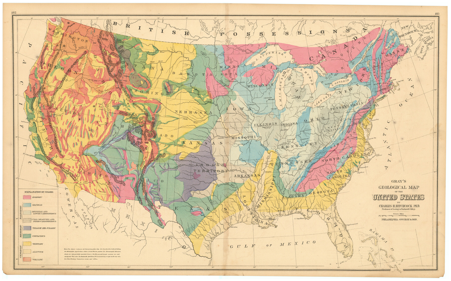
Gray's Geological Map of the United States
[recto]
-
Map/Doc
95174
-
Collection
General Map Collection
-
Object Dates
[1873] (Creation Date)
-
People and Organizations
O.W. Gray & Son (Publisher)
Charles H. Hitchcock (Author)
-
Subjects
Energy Surface United States
-
Height x Width
17.6 x 28.8 inches
44.7 x 73.2 cm
-
Medium
paper, etching/engraving/lithograph
-
Comments
To view text on verso, click the "Download PDF" link above.
Part of: General Map Collection
Flight Mission No. BQY-15M, Frame 7, Harris County

Print $20.00
- Digital $50.00
Flight Mission No. BQY-15M, Frame 7, Harris County
1953
Size 18.5 x 22.4 inches
Map/Doc 85305
Fort Bend County Boundary File 1a

Print $8.00
- Digital $50.00
Fort Bend County Boundary File 1a
Size 12.9 x 8.1 inches
Map/Doc 53555
El Paso Street and Vicinity Map (Recto)

El Paso Street and Vicinity Map (Recto)
1962
Size 18.3 x 30.8 inches
Map/Doc 94175
Flight Mission No. DAG-21K, Frame 88, Matagorda County

Print $20.00
- Digital $50.00
Flight Mission No. DAG-21K, Frame 88, Matagorda County
1952
Size 18.6 x 22.4 inches
Map/Doc 86417
Township No. 5 South, Range No. 13 West, Indian Meridian, Oklahoma

Print $4.00
- Digital $50.00
Township No. 5 South, Range No. 13 West, Indian Meridian, Oklahoma
1928
Size 17.9 x 23.0 inches
Map/Doc 75142
Upton County Working Sketch 29

Print $40.00
- Digital $50.00
Upton County Working Sketch 29
1956
Size 50.6 x 36.0 inches
Map/Doc 69525
Calhoun County NRC Article 33.136 Sketch 6

Print $24.00
- Digital $50.00
Calhoun County NRC Article 33.136 Sketch 6
2014
Size 18.0 x 24.0 inches
Map/Doc 94462
Hudspeth County Sketch File 15

Print $9.00
- Digital $50.00
Hudspeth County Sketch File 15
1927
Size 14.3 x 8.8 inches
Map/Doc 26944
Victoria County Sketch File 9

Print $8.00
- Digital $50.00
Victoria County Sketch File 9
1938
Size 14.3 x 8.8 inches
Map/Doc 39530
Starr County Working Sketch 21

Print $20.00
- Digital $50.00
Starr County Working Sketch 21
1982
Size 32.6 x 33.7 inches
Map/Doc 63937
Gillespie County Working Sketch 13

Print $20.00
- Digital $50.00
Gillespie County Working Sketch 13
2008
Size 22.8 x 31.8 inches
Map/Doc 88831
Dimmit County Sketch File 43

Print $20.00
- Digital $50.00
Dimmit County Sketch File 43
1905
Size 22.1 x 19.2 inches
Map/Doc 11353
You may also like
Montgomery County Rolled Sketch 42

Print $20.00
- Digital $50.00
Montgomery County Rolled Sketch 42
1939
Size 14.2 x 20.5 inches
Map/Doc 6817
Flight Mission No. BRA-7M, Frame 184, Jefferson County

Print $20.00
- Digital $50.00
Flight Mission No. BRA-7M, Frame 184, Jefferson County
1953
Size 18.6 x 22.3 inches
Map/Doc 85552
Connected Map of Austin's Colony

Print $20.00
- Digital $50.00
Connected Map of Austin's Colony
1892
Size 46.9 x 43.5 inches
Map/Doc 76076
[Sketch for Mineral Application 16787 - Pecos River Bed, A. T. Freet]
![65632, [Sketch for Mineral Application 16787 - Pecos River Bed, A. T. Freet], General Map Collection](https://historictexasmaps.com/wmedia_w700/maps/65632-1.tif.jpg)
Print $40.00
- Digital $50.00
[Sketch for Mineral Application 16787 - Pecos River Bed, A. T. Freet]
Size 70.8 x 18.9 inches
Map/Doc 65632
Hunt County Sketch File 31

Print $6.00
- Digital $50.00
Hunt County Sketch File 31
1862
Size 9.8 x 8.0 inches
Map/Doc 27135
Map of San Patricio County

Print $20.00
- Digital $50.00
Map of San Patricio County
1863
Size 17.9 x 26.3 inches
Map/Doc 4018
Presidio County Sketch File 70b

Print $6.00
- Digital $50.00
Presidio County Sketch File 70b
Size 11.2 x 8.9 inches
Map/Doc 34671
Kimble County Working Sketch 41

Print $20.00
- Digital $50.00
Kimble County Working Sketch 41
1948
Size 36.1 x 33.2 inches
Map/Doc 70109
Flight Mission No. BRA-8M, Frame 143, Jefferson County

Print $20.00
- Digital $50.00
Flight Mission No. BRA-8M, Frame 143, Jefferson County
1953
Size 18.9 x 22.5 inches
Map/Doc 85635
Crockett County Rolled Sketch 37

Print $20.00
- Digital $50.00
Crockett County Rolled Sketch 37
Size 36.7 x 29.3 inches
Map/Doc 5589
La Salle County Sketch File 5

Print $2.00
- Digital $50.00
La Salle County Sketch File 5
Size 6.9 x 8.9 inches
Map/Doc 29452
El Paso County Working Sketch 19

Print $20.00
- Digital $50.00
El Paso County Working Sketch 19
1960
Size 20.8 x 20.8 inches
Map/Doc 69041