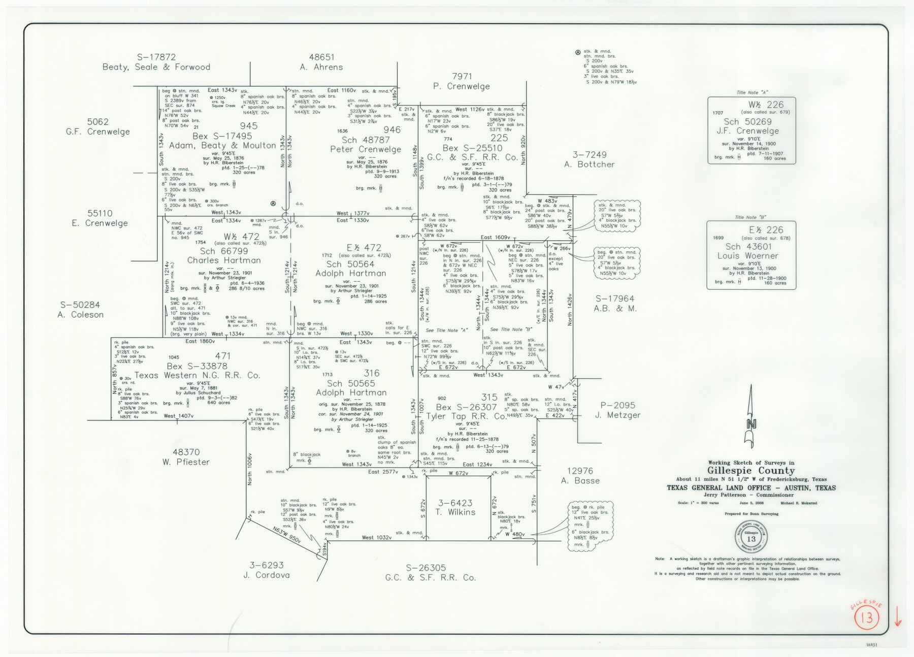
Gillespie County Working Sketch 13
-
Map/Doc
88831
-
Collection
General Map Collection
-
Object Dates
6/5/2008 (Creation Date)
-
People and Organizations
Jerry E. Patterson (GLO Commissioner)
Michael R. Mokarzel (Draftsman)
-
Counties
Gillespie
-
Subjects
Surveying Working Sketch
-
Height x Width
22.8 x 31.8 inches
57.9 x 80.8 cm
-
Scale
1" = 300 varas
-
Comments
Surveys located about 11 miles North 51 1/2 degrees West of Fredericksburg, Texas.
Part of: General Map Collection
Galveston County Sketch File 40

Print $18.00
- Digital $50.00
Galveston County Sketch File 40
1937
Size 14.3 x 8.8 inches
Map/Doc 23442
Flight Mission No. CRC-3R, Frame 167, Chambers County

Print $20.00
- Digital $50.00
Flight Mission No. CRC-3R, Frame 167, Chambers County
1956
Size 18.7 x 22.3 inches
Map/Doc 84849
Mason County Working Sketch 9

Print $20.00
- Digital $50.00
Mason County Working Sketch 9
1949
Size 34.4 x 29.4 inches
Map/Doc 70845
Montgomery County Working Sketch 69

Print $20.00
- Digital $50.00
Montgomery County Working Sketch 69
1973
Size 27.3 x 37.7 inches
Map/Doc 71176
Nueces County NRC Article 33.136 Sketch 5

Print $48.00
- Digital $50.00
Nueces County NRC Article 33.136 Sketch 5
2002
Size 22.9 x 34.7 inches
Map/Doc 78666
Gulf of Mexico

Print $20.00
- Digital $50.00
Gulf of Mexico
1900
Size 18.2 x 28.1 inches
Map/Doc 72647
Young County Rolled Sketch 9

Print $20.00
- Digital $50.00
Young County Rolled Sketch 9
1921
Size 24.0 x 22.6 inches
Map/Doc 8297
Armstrong County Sketch File 2

Print $40.00
- Digital $50.00
Armstrong County Sketch File 2
Size 21.5 x 40.0 inches
Map/Doc 10371
Sabine and Neches Rivers

Print $20.00
- Digital $50.00
Sabine and Neches Rivers
1973
Size 19.7 x 44.6 inches
Map/Doc 69818
Harris County Working Sketch 15

Print $20.00
- Digital $50.00
Harris County Working Sketch 15
1916
Size 29.3 x 41.2 inches
Map/Doc 65907
Map of Presidio County, Texas

Print $40.00
- Digital $50.00
Map of Presidio County, Texas
Size 42.6 x 86.0 inches
Map/Doc 76071
Crockett County Rolled Sketch 27A

Print $40.00
- Digital $50.00
Crockett County Rolled Sketch 27A
1925
Size 22.3 x 59.5 inches
Map/Doc 8692
You may also like
Eubank Farm N/2 of NE/4 Section 3, Block D3

Print $20.00
- Digital $50.00
Eubank Farm N/2 of NE/4 Section 3, Block D3
Size 20.9 x 14.0 inches
Map/Doc 92336
Flight Mission No. BQY-4M, Frame 68, Harris County

Print $20.00
- Digital $50.00
Flight Mission No. BQY-4M, Frame 68, Harris County
1953
Size 18.6 x 22.4 inches
Map/Doc 85277
A General Map of the Roman Empire Shewing the Situation of all its Provinces & ye Seats of ye Barbarous Nations on their Frontiers

Print $20.00
- Digital $50.00
A General Map of the Roman Empire Shewing the Situation of all its Provinces & ye Seats of ye Barbarous Nations on their Frontiers
1744
Size 10.8 x 20.5 inches
Map/Doc 96644
[Gulf, Colorado & Santa Fe]
![64575, [Gulf, Colorado & Santa Fe], General Map Collection](https://historictexasmaps.com/wmedia_w700/maps/64575.tif.jpg)
Print $40.00
- Digital $50.00
[Gulf, Colorado & Santa Fe]
Size 31.9 x 71.7 inches
Map/Doc 64575
Concho County Sketch File 46

Print $24.00
- Digital $50.00
Concho County Sketch File 46
1961
Size 14.2 x 8.6 inches
Map/Doc 19213
Flight Mission No. BRA-7M, Frame 9, Jefferson County

Print $20.00
- Digital $50.00
Flight Mission No. BRA-7M, Frame 9, Jefferson County
1953
Size 18.7 x 22.3 inches
Map/Doc 85460
Lampasas County Rolled Sketch 1

Print $20.00
- Digital $50.00
Lampasas County Rolled Sketch 1
1975
Size 22.0 x 28.2 inches
Map/Doc 6564
Menard County Sketch File 3

Print $40.00
- Digital $50.00
Menard County Sketch File 3
Size 16.3 x 12.9 inches
Map/Doc 31488
Comal County Sketch File 6

Print $6.00
- Digital $50.00
Comal County Sketch File 6
Size 10.3 x 8.1 inches
Map/Doc 19008
Foard County Boundary File 6

Print $10.00
- Digital $50.00
Foard County Boundary File 6
Size 7.2 x 8.7 inches
Map/Doc 53548
Flight Mission No. DAG-21K, Frame 124, Matagorda County

Print $20.00
- Digital $50.00
Flight Mission No. DAG-21K, Frame 124, Matagorda County
1952
Size 18.5 x 22.4 inches
Map/Doc 86450
No. 2 Chart of Corpus Christi Pass, Texas

Print $20.00
- Digital $50.00
No. 2 Chart of Corpus Christi Pass, Texas
1878
Size 18.3 x 27.4 inches
Map/Doc 73022