Galveston County Sketch File 40
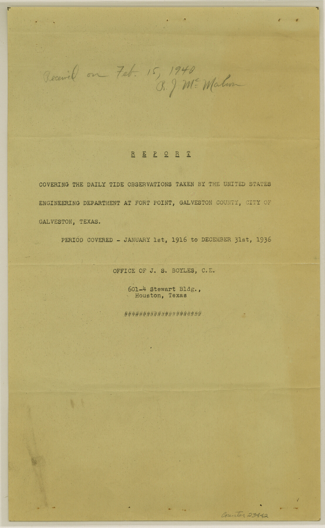
Report covering the daily tide observations taken by the United States Engineering Department at Fort Point, Galveston County, City of Galveston, Texas. Period covered - January 1st, 1916 to December 31st, 1936
-
Map/Doc
23442
-
Collection
General Map Collection
-
Object Dates
1890 (Survey Date)
1937/1/22 (Creation Date)
-
People and Organizations
J. Stuart Boyles (Surveyor/Engineer)
-
Counties
Galveston
-
Subjects
Surveying Sketch File
-
Height x Width
14.3 x 8.8 inches
36.3 x 22.4 cm
-
Medium
paper, print
-
Features
Galveston
Gulf of Mexico
Dickinson Bayou
Corpus Christi
Port Aransas
New Orleans
Beaumont
Brownsville
Government Wharf
Morgan's Point
Texas City
Houston Ship Channel
Red Fish North
Red Fish South
Fort Point
Part of: General Map Collection
Flight Mission No. DIX-6P, Frame 199, Aransas County

Print $20.00
- Digital $50.00
Flight Mission No. DIX-6P, Frame 199, Aransas County
1956
Size 18.8 x 22.6 inches
Map/Doc 83861
Red River County Red River District

Print $20.00
- Digital $50.00
Red River County Red River District
1879
Size 24.9 x 21.8 inches
Map/Doc 3976
Flight Mission No. BQY-4M, Frame 113, Harris County

Print $20.00
- Digital $50.00
Flight Mission No. BQY-4M, Frame 113, Harris County
1953
Size 18.8 x 22.4 inches
Map/Doc 85280
Energy Map of Texas

Print $20.00
- Digital $50.00
Energy Map of Texas
2020
Size 36.0 x 36.0 inches
Map/Doc 96436
Map of Cameron County

Print $40.00
- Digital $50.00
Map of Cameron County
1895
Size 48.9 x 28.9 inches
Map/Doc 4901
Polk County Working Sketch 23b

Print $40.00
- Digital $50.00
Polk County Working Sketch 23b
1957
Size 28.8 x 54.6 inches
Map/Doc 71639
Shelby County Rolled Sketch 20

Print $20.00
- Digital $50.00
Shelby County Rolled Sketch 20
1983
Size 24.7 x 37.2 inches
Map/Doc 7785
Culberson County Rolled Sketch 36

Print $20.00
- Digital $50.00
Culberson County Rolled Sketch 36
1934
Size 32.5 x 23.2 inches
Map/Doc 8750
Navarro County Rolled Sketch 7

Print $20.00
- Digital $50.00
Navarro County Rolled Sketch 7
Size 45.0 x 34.6 inches
Map/Doc 10308
Culberson County Working Sketch 85

Print $20.00
- Digital $50.00
Culberson County Working Sketch 85
1981
Size 37.0 x 36.9 inches
Map/Doc 68539
Limestone County Working Sketch 11

Print $20.00
- Digital $50.00
Limestone County Working Sketch 11
1922
Size 36.1 x 33.9 inches
Map/Doc 70561
Clay County Sketch File 37

Print $8.00
- Digital $50.00
Clay County Sketch File 37
1935
Size 11.6 x 7.2 inches
Map/Doc 18465
You may also like
Scurry County Rolled Sketch 3

Print $40.00
- Digital $50.00
Scurry County Rolled Sketch 3
Size 50.2 x 46.7 inches
Map/Doc 9912
Refugio County Sketch File 21

Print $20.00
- Digital $50.00
Refugio County Sketch File 21
1933
Size 17.8 x 22.1 inches
Map/Doc 12248
Hudspeth County Sketch File 13

Print $18.00
- Digital $50.00
Hudspeth County Sketch File 13
1915
Size 13.3 x 8.9 inches
Map/Doc 26929
Stonewall County Boundary File 1

Print $34.00
- Digital $50.00
Stonewall County Boundary File 1
Size 9.0 x 8.4 inches
Map/Doc 58938
Field Notes of a Survey of Padre Island

Print $20.00
- Digital $50.00
Field Notes of a Survey of Padre Island
1941
Size 43.2 x 30.0 inches
Map/Doc 2271
Shelby County Rolled Sketch 11

Print $20.00
- Digital $50.00
Shelby County Rolled Sketch 11
1945
Size 24.9 x 28.6 inches
Map/Doc 7779
Karnes County Rolled Sketch 4

Print $20.00
- Digital $50.00
Karnes County Rolled Sketch 4
1961
Size 33.4 x 37.7 inches
Map/Doc 9667
Kimble County Sketch File 8

Print $14.00
- Digital $50.00
Kimble County Sketch File 8
1847
Size 7.7 x 7.0 inches
Map/Doc 28920
Stonewall County Working Sketch 27

Print $20.00
- Digital $50.00
Stonewall County Working Sketch 27
1976
Size 20.7 x 29.9 inches
Map/Doc 62334
Flight Mission No. CLL-1N, Frame 182, Willacy County

Print $20.00
- Digital $50.00
Flight Mission No. CLL-1N, Frame 182, Willacy County
1954
Size 18.4 x 22.0 inches
Map/Doc 87052
Flight Mission No. BQR-4K, Frame 67, Brazoria County

Print $20.00
- Digital $50.00
Flight Mission No. BQR-4K, Frame 67, Brazoria County
1952
Size 18.7 x 22.5 inches
Map/Doc 84000
Glasscock County Rolled Sketch 3

Print $20.00
- Digital $50.00
Glasscock County Rolled Sketch 3
1906
Size 19.0 x 13.7 inches
Map/Doc 6014