Hudspeth County Sketch File 15
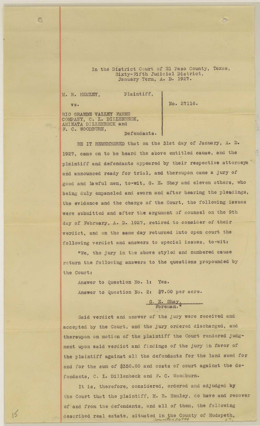
[Decree of Court - M. R. Hemley vs. Rio Grande Valley Farms Company, C. L. Dillenbeck, Aminata Dillenbeck and F. C. Woodburn]
-
Map/Doc
26944
-
Collection
General Map Collection
-
Object Dates
1/1927 (Creation Date)
1925 (Creation Date)
-
People and Organizations
R.E. Hardaway (Surveyor/Engineer)
W.L. Rider (Surveyor/Engineer)
-
Counties
Hudspeth
-
Subjects
Surveying Sketch File
-
Height x Width
14.3 x 8.8 inches
36.3 x 22.4 cm
-
Medium
paper, print
Part of: General Map Collection
Freestone County Sketch File 14a

Print $6.00
- Digital $50.00
Freestone County Sketch File 14a
1861
Size 5.3 x 5.9 inches
Map/Doc 23067
Montague County Working Sketch 41

Print $40.00
- Digital $50.00
Montague County Working Sketch 41
1923
Size 43.3 x 70.1 inches
Map/Doc 65350
Culberson County Working Sketch 65

Print $40.00
- Digital $50.00
Culberson County Working Sketch 65
1975
Size 49.0 x 34.9 inches
Map/Doc 68519
Crockett County Rolled Sketch 93

Print $20.00
- Digital $50.00
Crockett County Rolled Sketch 93
1979
Size 18.8 x 18.9 inches
Map/Doc 5633

Flight Mission No. DCL-7C, Frame 28, Kenedy County

Print $20.00
- Digital $50.00
Flight Mission No. DCL-7C, Frame 28, Kenedy County
1943
Size 15.4 x 15.4 inches
Map/Doc 86020
Harrison County Sketch File 11

Print $22.00
- Digital $50.00
Harrison County Sketch File 11
1904
Size 9.2 x 9.3 inches
Map/Doc 26052
Flight Mission No. BQR-4K, Frame 70, Brazoria County

Print $20.00
- Digital $50.00
Flight Mission No. BQR-4K, Frame 70, Brazoria County
1952
Size 18.8 x 22.4 inches
Map/Doc 84003
Tarrant's Key and Guide to Dallas

Print $3.00
- Digital $50.00
Tarrant's Key and Guide to Dallas
1922
Size 7.9 x 10.4 inches
Map/Doc 89257
Sketch of a portion of the Texas Coast showing the relative positions of different harbours with the interior Military Posts, and the roads communicating with them, also two new routes from Black Point and Lamar to San Antonio

Print $20.00
- Digital $50.00
Sketch of a portion of the Texas Coast showing the relative positions of different harbours with the interior Military Posts, and the roads communicating with them, also two new routes from Black Point and Lamar to San Antonio
1855
Size 27.5 x 18.2 inches
Map/Doc 72708
[Plat of Texas and Pacific Railroad Company Block Lines, 80 Mile Reserve]
![3124, [Plat of Texas and Pacific Railroad Company Block Lines, 80 Mile Reserve], General Map Collection](https://historictexasmaps.com/wmedia_w700/maps/3124-1.tif.jpg)
Print $40.00
- Digital $50.00
[Plat of Texas and Pacific Railroad Company Block Lines, 80 Mile Reserve]
1876
Size 43.5 x 46.3 inches
Map/Doc 3124
Blanco County Working Sketch 29

Print $40.00
- Digital $50.00
Blanco County Working Sketch 29
1969
Size 52.4 x 33.4 inches
Map/Doc 67389
You may also like
Flight Mission No. CRC-6R, Frame 39, Chambers County

Print $20.00
- Digital $50.00
Flight Mission No. CRC-6R, Frame 39, Chambers County
1956
Size 18.7 x 22.5 inches
Map/Doc 84972
[Sections 94 and 826-831 along Red River]
![93161, [Sections 94 and 826-831 along Red River], Twichell Survey Records](https://historictexasmaps.com/wmedia_w700/maps/93161-1.tif.jpg)
Print $40.00
- Digital $50.00
[Sections 94 and 826-831 along Red River]
Size 43.2 x 111.4 inches
Map/Doc 93161
Flight Mission No. BRE-1P, Frame 68, Nueces County

Print $20.00
- Digital $50.00
Flight Mission No. BRE-1P, Frame 68, Nueces County
1956
Size 17.7 x 21.8 inches
Map/Doc 86650
Flight Mission No. CLL-4N, Frame 35, Willacy County

Print $20.00
- Digital $50.00
Flight Mission No. CLL-4N, Frame 35, Willacy County
1954
Size 18.3 x 22.0 inches
Map/Doc 87108
Upton County Working Sketch 55

Print $20.00
- Digital $50.00
Upton County Working Sketch 55
Size 25.7 x 36.7 inches
Map/Doc 69552
Ward County Working Sketch 24

Print $20.00
- Digital $50.00
Ward County Working Sketch 24
1955
Size 41.7 x 37.0 inches
Map/Doc 72330
Stephens County

Print $20.00
- Digital $50.00
Stephens County
1940
Size 42.9 x 41.0 inches
Map/Doc 63045
Hopkins County Working Sketch Graphic Index

Print $20.00
- Digital $50.00
Hopkins County Working Sketch Graphic Index
1942
Size 40.6 x 38.7 inches
Map/Doc 76581
Hemphill County Sketch File 10

Print $6.00
- Digital $50.00
Hemphill County Sketch File 10
1903
Size 14.3 x 8.8 inches
Map/Doc 26315
Nueces County Sketch File 50

Print $463.00
- Digital $50.00
Nueces County Sketch File 50
Size 9.6 x 6.2 inches
Map/Doc 32673
The Republic County of Shelby. December 29, 1845

Print $20.00
The Republic County of Shelby. December 29, 1845
2020
Size 20.0 x 21.7 inches
Map/Doc 96288
Rand McNally New Official Railroad Map of the United States and Southern Canada

Print $20.00
- Digital $50.00
Rand McNally New Official Railroad Map of the United States and Southern Canada
1910
Size 29.5 x 40.0 inches
Map/Doc 95860