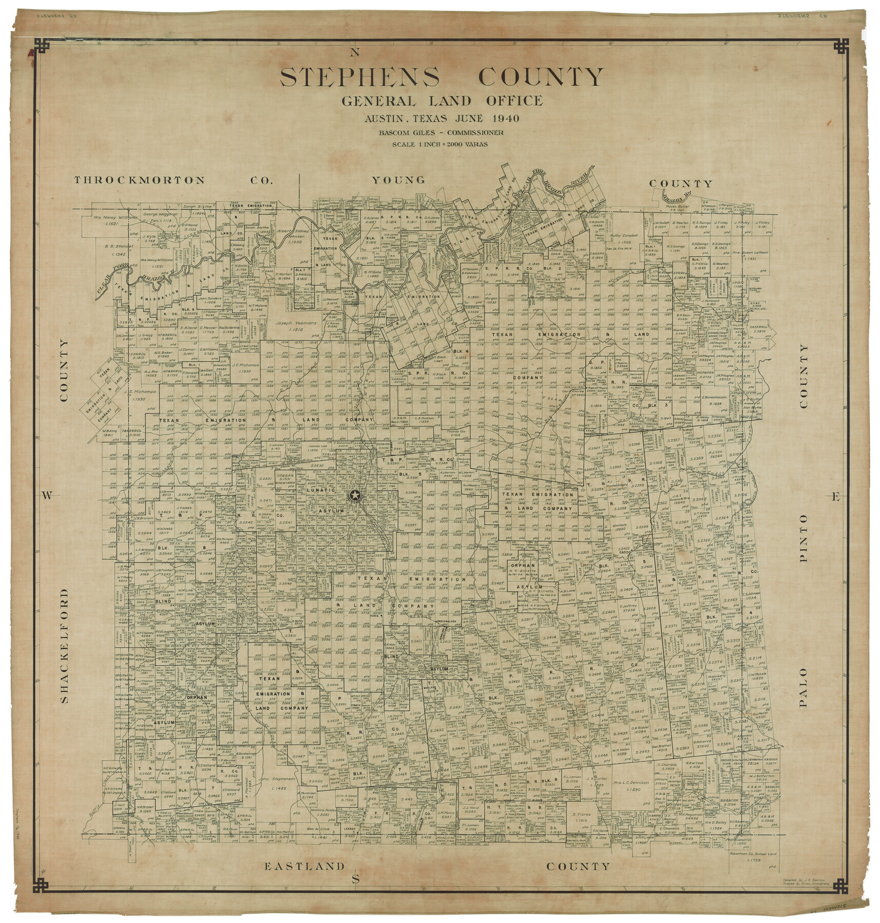
Stephens County
-
Map/Doc
63045
-
Collection
General Map Collection
-
Object Dates
1940 (Creation Date)
-
People and Organizations
Texas General Land Office (Publisher)
Bascom Giles (GLO Commissioner)
J.O. Barrow (Compiler)
-
Counties
Stephens
-
Subjects
County
-
Height x Width
42.9 x 41.0 inches
109.0 x 104.1 cm
-
Comments
Traced by Eltea Armstrong.
Part of: General Map Collection
Brewster County Sketch File N-25

Print $28.00
- Digital $50.00
Brewster County Sketch File N-25
1952
Size 24.4 x 9.1 inches
Map/Doc 15700
Morris County Rolled Sketch 2A

Print $20.00
- Digital $50.00
Morris County Rolled Sketch 2A
Size 24.0 x 18.7 inches
Map/Doc 10256
Tyler County Sketch File 8

Print $4.00
- Digital $50.00
Tyler County Sketch File 8
Size 8.6 x 6.8 inches
Map/Doc 38642
Frio County Working Sketch 27

Print $20.00
- Digital $50.00
Frio County Working Sketch 27
Size 25.3 x 36.8 inches
Map/Doc 78193
A Map of the British Empire in North America

Print $20.00
- Digital $50.00
A Map of the British Empire in North America
1774
Size 22.1 x 15.1 inches
Map/Doc 93733
Edwards County Working Sketch 61

Print $20.00
- Digital $50.00
Edwards County Working Sketch 61
1954
Size 21.0 x 40.3 inches
Map/Doc 68937
Tyler County Sketch File 3a

Print $4.00
- Digital $50.00
Tyler County Sketch File 3a
1857
Size 6.2 x 8.2 inches
Map/Doc 38626
Flight Mission No. DAH-9M, Frame 87, Orange County

Print $20.00
- Digital $50.00
Flight Mission No. DAH-9M, Frame 87, Orange County
1953
Size 18.5 x 22.3 inches
Map/Doc 86851
Cass County Sketch File 5 1/2

Print $4.00
- Digital $50.00
Cass County Sketch File 5 1/2
1851
Size 6.1 x 8.5 inches
Map/Doc 17404
Anderson County Sketch File 4

Print $6.00
- Digital $50.00
Anderson County Sketch File 4
Size 8.7 x 6.4 inches
Map/Doc 12743
Trinity County Working Sketch 15

Print $20.00
- Digital $50.00
Trinity County Working Sketch 15
1974
Size 30.5 x 32.5 inches
Map/Doc 69464
Brazos River Entrance

Print $20.00
- Digital $50.00
Brazos River Entrance
1925
Size 31.0 x 41.4 inches
Map/Doc 69974
You may also like
Brazos River, Washington Sheet

Print $6.00
- Digital $50.00
Brazos River, Washington Sheet
1936
Size 30.4 x 24.7 inches
Map/Doc 65277
Wharton County Sketch File 9

Print $4.00
- Digital $50.00
Wharton County Sketch File 9
1884
Size 9.1 x 11.7 inches
Map/Doc 39929
Travis County Appraisal District Plat Map 2_3013

Print $20.00
- Digital $50.00
Travis County Appraisal District Plat Map 2_3013
Size 21.5 x 26.4 inches
Map/Doc 94220
Flight Mission No. DQN-7K, Frame 14, Calhoun County

Print $20.00
- Digital $50.00
Flight Mission No. DQN-7K, Frame 14, Calhoun County
1953
Size 17.2 x 19.1 inches
Map/Doc 84465
Floyd County Rolled Sketch 11

Print $20.00
- Digital $50.00
Floyd County Rolled Sketch 11
2000
Size 15.5 x 20.9 inches
Map/Doc 5884
Brazoria County

Print $20.00
- Digital $50.00
Brazoria County
1873
Size 26.7 x 26.1 inches
Map/Doc 858
Flight Mission No. DAG-18K, Frame 184, Matagorda County

Print $20.00
- Digital $50.00
Flight Mission No. DAG-18K, Frame 184, Matagorda County
1952
Size 18.6 x 22.4 inches
Map/Doc 86376
Galveston The Year-'Round Resort

Galveston The Year-'Round Resort
1912
Size 7.8 x 10.2 inches
Map/Doc 97058
Atascosa County Rolled Sketch 4

Print $20.00
- Digital $50.00
Atascosa County Rolled Sketch 4
Size 21.0 x 15.8 inches
Map/Doc 5087
Garza County Sketch File 7

Print $4.00
- Digital $50.00
Garza County Sketch File 7
1900
Size 13.3 x 8.5 inches
Map/Doc 24060
Wichita County Rolled Sketch 13

Print $20.00
- Digital $50.00
Wichita County Rolled Sketch 13
Size 25.7 x 16.6 inches
Map/Doc 8250
Crockett County Sketch File 92

Print $21.00
- Digital $50.00
Crockett County Sketch File 92
1925
Size 11.4 x 8.8 inches
Map/Doc 19937