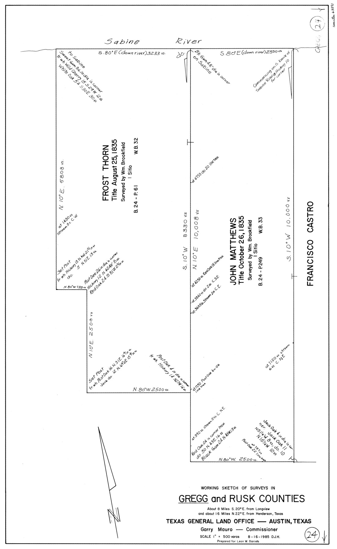
Gregg County Working Sketch 24
-
Map/Doc
63291
-
Collection
General Map Collection
-
Object Dates
8/16/1985 (Creation Date)
-
People and Organizations
Douglas Howard (Draftsman)
-
Counties
Gregg Rusk
-
Subjects
Surveying Working Sketch
-
Height x Width
26.6 x 16.3 inches
67.6 x 41.4 cm
-
Scale
1" = 500 varas
Part of: General Map Collection
Jeff Davis County Sketch File 48

Print $3.00
- Digital $50.00
Jeff Davis County Sketch File 48
2002
Size 14.0 x 8.5 inches
Map/Doc 82923
Coleman County Working Sketch 2

Print $20.00
- Digital $50.00
Coleman County Working Sketch 2
1917
Size 15.0 x 16.8 inches
Map/Doc 68068
Dallam County Sketch File 4

Print $20.00
- Digital $50.00
Dallam County Sketch File 4
Size 27.7 x 8.5 inches
Map/Doc 11279

Haskell County

Print $20.00
- Digital $50.00
Haskell County
1879
Size 21.0 x 20.4 inches
Map/Doc 1127
Jeff Davis County Working Sketch 15

Print $20.00
- Digital $50.00
Jeff Davis County Working Sketch 15
1950
Size 34.6 x 29.0 inches
Map/Doc 66510
Map of Wilbarger County Young Land District formerly Fannin Land District

Print $20.00
- Digital $50.00
Map of Wilbarger County Young Land District formerly Fannin Land District
1859
Size 22.7 x 20.6 inches
Map/Doc 4146
Madison County Working Sketch 10

Print $20.00
- Digital $50.00
Madison County Working Sketch 10
1960
Size 34.7 x 32.0 inches
Map/Doc 70772
McMullen County Working Sketch 61

Print $20.00
- Digital $50.00
McMullen County Working Sketch 61
1990
Size 25.2 x 19.8 inches
Map/Doc 70762
Sketches of Surveys in Montgomery Co.

Print $2.00
- Digital $50.00
Sketches of Surveys in Montgomery Co.
1845
Size 10.2 x 8.0 inches
Map/Doc 69731
Val Verde Co.

Print $20.00
- Digital $50.00
Val Verde Co.
1908
Size 40.5 x 38.4 inches
Map/Doc 63099
Coke County Sketch File 30

Print $40.00
- Digital $50.00
Coke County Sketch File 30
Size 12.2 x 17.6 inches
Map/Doc 18641
You may also like
Map Showing Lands Surveyed for Tom Pinkston, W. D. Twichell and H. Y. Quarles in Stephens County, Texas

Print $20.00
- Digital $50.00
Map Showing Lands Surveyed for Tom Pinkston, W. D. Twichell and H. Y. Quarles in Stephens County, Texas
1919
Size 19.7 x 21.2 inches
Map/Doc 91892
Bailey County Rolled Sketch 6

Print $20.00
- Digital $50.00
Bailey County Rolled Sketch 6
Size 17.4 x 12.9 inches
Map/Doc 5111
Flight Mission No. DQO-8K, Frame 72, Galveston County

Print $20.00
- Digital $50.00
Flight Mission No. DQO-8K, Frame 72, Galveston County
1952
Size 18.7 x 22.4 inches
Map/Doc 85176
Denton County Working Sketch 20

Print $20.00
- Digital $50.00
Denton County Working Sketch 20
1978
Size 31.6 x 33.2 inches
Map/Doc 68625
Flight Mission No. CGN-1G, Frame 26, San Patricio County

Print $20.00
- Digital $50.00
Flight Mission No. CGN-1G, Frame 26, San Patricio County
1950
Size 9.4 x 9.4 inches
Map/Doc 87113
The Beautiful Valley of the Lower Rio Grande

The Beautiful Valley of the Lower Rio Grande
1925
Map/Doc 96735
[Surveys in the vicinity of the Martina Olivares survey]
![90891, [Surveys in the vicinity of the Martina Olivares survey], Twichell Survey Records](https://historictexasmaps.com/wmedia_w700/maps/90891-1.tif.jpg)
Print $3.00
- Digital $50.00
[Surveys in the vicinity of the Martina Olivares survey]
1911
Size 10.3 x 16.9 inches
Map/Doc 90891
El Paso County State Real Property Sketch 3

Print $20.00
- Digital $50.00
El Paso County State Real Property Sketch 3
2012
Size 25.1 x 36.4 inches
Map/Doc 93700
Maverick County Sketch File 26

Print $14.00
- Digital $50.00
Maverick County Sketch File 26
1955
Size 11.3 x 8.7 inches
Map/Doc 31153
Texas-Oklahoma, Red River, Big Bend Area

Print $40.00
- Digital $50.00
Texas-Oklahoma, Red River, Big Bend Area
1921
Size 23.3 x 57.6 inches
Map/Doc 75251
Map of Caldwell County, Texas

Print $20.00
Map of Caldwell County, Texas
1879
Size 17.4 x 21.5 inches
Map/Doc 88914
Leon County Rolled Sketch 31A

Print $20.00
- Digital $50.00
Leon County Rolled Sketch 31A
1995
Size 38.9 x 15.4 inches
Map/Doc 6615