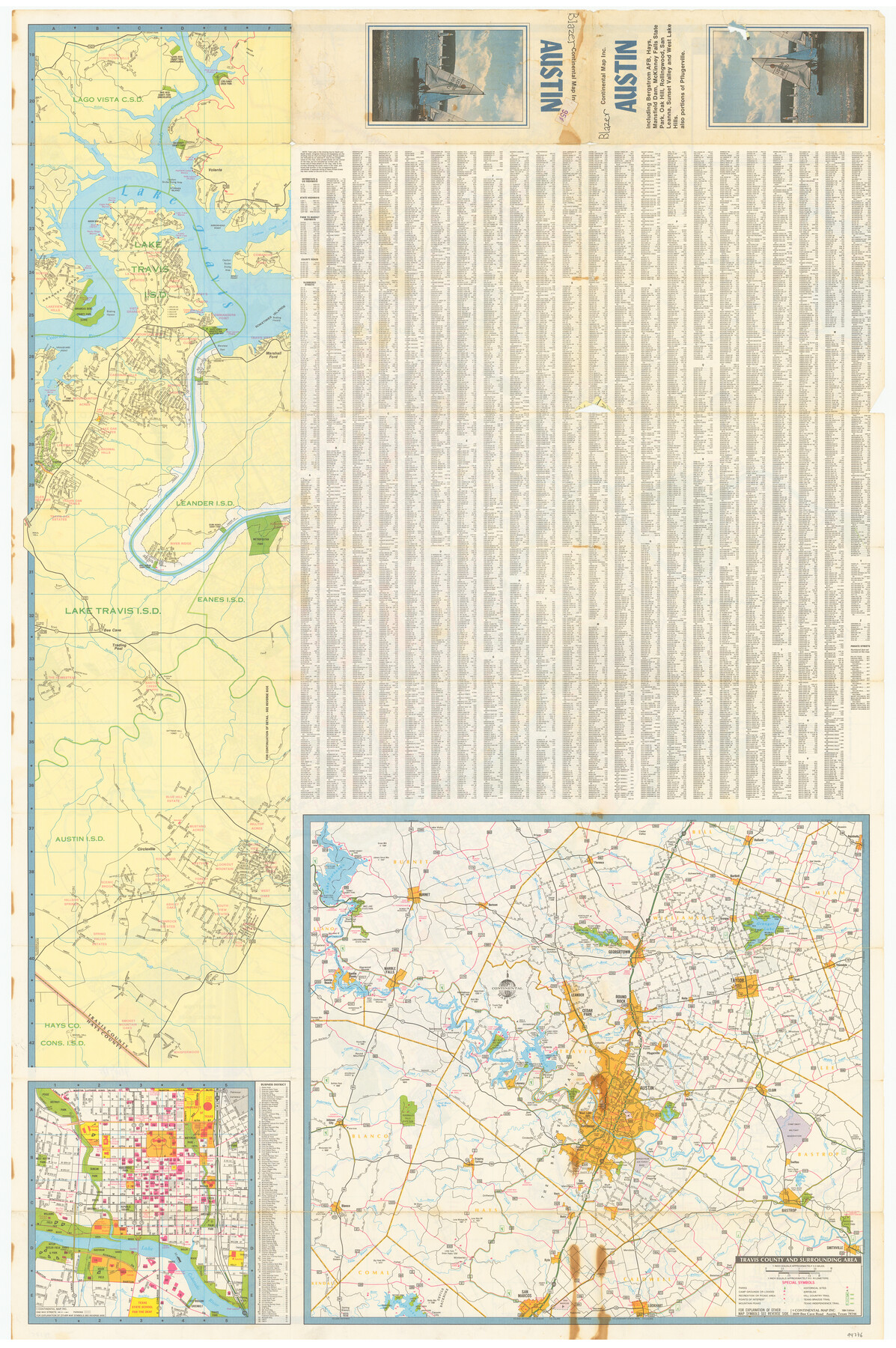
Austin including Bergstrom AFB, Hays, Mansfield Dam, McKinney Falls State Park, Oak Hill, Rollingwood, San Leanna, Sunset Valley and West Lake Hills - also portions of Pflugerville
[Verso - Map of Travis County and Surrounding Area]
-
Map/Doc
94376
-
Collection
General Map Collection
-
Object Dates
1980 (Copyright Date)
1984 (Edition Date)
-
People and Organizations
Continental Map Inc. (Publisher)
-
Counties
Travis
-
Subjects
City
-
Height x Width
38.5 x 25.6 inches
97.8 x 65.0 cm
-
Medium
paper, etching/engraving/lithograph
-
Comments
For map of Austin on recto, see 94375. For research only.
Related maps
Austin including Bergstrom AFB, Hays, Mansfield Dam, McKinney Falls State Park, Oak Hill, Rollingwood, San Leanna, Sunset Valley and West Lake Hills - also portions of Pflugerville

Austin including Bergstrom AFB, Hays, Mansfield Dam, McKinney Falls State Park, Oak Hill, Rollingwood, San Leanna, Sunset Valley and West Lake Hills - also portions of Pflugerville
Size 38.4 x 25.6 inches
Map/Doc 94375
Part of: General Map Collection
Shelby County Rolled Sketch 6

Print $20.00
- Digital $50.00
Shelby County Rolled Sketch 6
Size 26.7 x 20.9 inches
Map/Doc 7776
Right of Way and Track Map, Galveston, Harrisburg & San Antonio Ry. operated by the T. & N. O. R.R. Co., Victoria Division, Rosenberg to Beeville

Print $40.00
- Digital $50.00
Right of Way and Track Map, Galveston, Harrisburg & San Antonio Ry. operated by the T. & N. O. R.R. Co., Victoria Division, Rosenberg to Beeville
1918
Size 24.8 x 57.1 inches
Map/Doc 76159
Flight Mission No. DAG-24K, Frame 150, Matagorda County

Print $20.00
- Digital $50.00
Flight Mission No. DAG-24K, Frame 150, Matagorda County
1953
Size 18.5 x 22.2 inches
Map/Doc 86564
Bexar County Boundary File 3

Print $6.00
- Digital $50.00
Bexar County Boundary File 3
Size 8.2 x 3.6 inches
Map/Doc 50536
Brazoria County Rolled Sketch 47

Print $20.00
- Digital $50.00
Brazoria County Rolled Sketch 47
1951
Size 17.4 x 22.6 inches
Map/Doc 5180
Chambers County NRC Article 33.136 Sketch 10

Print $44.00
- Digital $50.00
Chambers County NRC Article 33.136 Sketch 10
2014
Size 24.0 x 36.0 inches
Map/Doc 94498
Webb County Boundary File 3a

Print $10.00
- Digital $50.00
Webb County Boundary File 3a
Size 14.2 x 8.7 inches
Map/Doc 59753
Bailey County Sketch File 16

Print $8.00
- Digital $50.00
Bailey County Sketch File 16
1941
Size 14.2 x 8.7 inches
Map/Doc 13977
Flight Mission No. DAG-22K, Frame 88, Matagorda County

Print $20.00
- Digital $50.00
Flight Mission No. DAG-22K, Frame 88, Matagorda County
1953
Size 18.6 x 22.4 inches
Map/Doc 86472
Houston County Working Sketch 13

Print $20.00
- Digital $50.00
Houston County Working Sketch 13
1956
Size 39.3 x 39.6 inches
Map/Doc 66243
Harris County NRC Article 33.136 Sketch 19

Print $50.00
- Digital $50.00
Harris County NRC Article 33.136 Sketch 19
2014
Size 24.6 x 36.6 inches
Map/Doc 95334
Travis County Boundary File 20

Print $6.00
- Digital $50.00
Travis County Boundary File 20
Size 14.4 x 9.2 inches
Map/Doc 59454
You may also like
Flight Mission No. DQN-1K, Frame 132, Calhoun County

Print $20.00
- Digital $50.00
Flight Mission No. DQN-1K, Frame 132, Calhoun County
1953
Size 18.4 x 22.1 inches
Map/Doc 84195
Denton County Sketch File 12

Print $4.00
- Digital $50.00
Denton County Sketch File 12
1856
Size 8.3 x 10.3 inches
Map/Doc 20711
Crockett County Working Sketch 14

Print $3.00
- Digital $50.00
Crockett County Working Sketch 14
1916
Size 12.1 x 9.1 inches
Map/Doc 68347
Parker County Sketch File 48

Print $20.00
- Digital $50.00
Parker County Sketch File 48
1858
Size 17.6 x 22.3 inches
Map/Doc 12152
From Citizens of Nacogdoches County to Redefine the Boundaries of Nacogdoches County, December 2, 1841

Print $20.00
From Citizens of Nacogdoches County to Redefine the Boundaries of Nacogdoches County, December 2, 1841
2020
Size 22.5 x 21.7 inches
Map/Doc 96395
Brazos County Working Sketch 4

Print $20.00
- Digital $50.00
Brazos County Working Sketch 4
1976
Size 22.5 x 20.6 inches
Map/Doc 67479
Hemphill County Rolled Sketch 17

Print $20.00
- Digital $50.00
Hemphill County Rolled Sketch 17
1965
Size 23.5 x 39.9 inches
Map/Doc 6199
Controlled Mosaic by Jack Amman Photogrammetric Engineers, Inc - Sheet 7

Print $20.00
- Digital $50.00
Controlled Mosaic by Jack Amman Photogrammetric Engineers, Inc - Sheet 7
1954
Size 20.0 x 24.0 inches
Map/Doc 83451
[Part of H. & G. N. Blocks 11 and 12]
![91565, [Part of H. & G. N. Blocks 11 and 12], Twichell Survey Records](https://historictexasmaps.com/wmedia_w700/maps/91565-1.tif.jpg)
Print $20.00
- Digital $50.00
[Part of H. & G. N. Blocks 11 and 12]
Size 21.5 x 16.7 inches
Map/Doc 91565
Orange County Sketch File 39

Print $20.00
- Digital $50.00
Orange County Sketch File 39
1964
Size 24.2 x 27.9 inches
Map/Doc 12127
Harris County Rolled Sketch R

Print $40.00
- Digital $50.00
Harris County Rolled Sketch R
1915
Size 20.3 x 93.8 inches
Map/Doc 9114
Map of Asia (Inset: Palestine)

Print $20.00
- Digital $50.00
Map of Asia (Inset: Palestine)
1844
Size 12.1 x 19.0 inches
Map/Doc 93548