Glasscock County Sketch File 1
Plat "OX" from Howard, Martin and Glasscock Counties Showing Resurvey of Blocks No. 34 Township 2 South and 35 Township 1 and 2, South Texas & Pacific Ry. Co. Reservation
-
Map/Doc
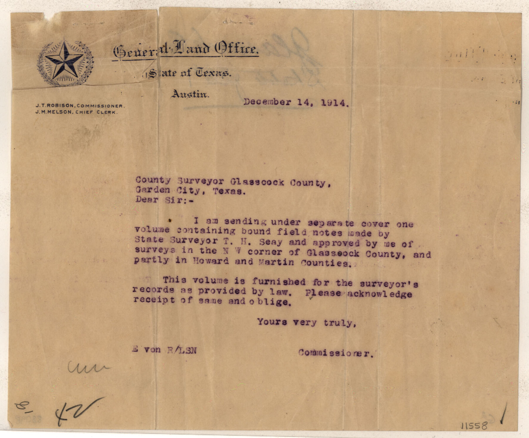
11558
-
Collection
General Map Collection
-
Object Dates
1913/8/14 (File Date)
-
People and Organizations
T.H. Seay (Surveyor/Engineer)
J.T. Robison (GLO Commissioner)
T.H. Seay (Draftsman)
-
Counties
Glasscock Howard Martin
-
Subjects
Surveying Sketch File
-
Height x Width
26.1 x 31.8 inches
66.3 x 80.8 cm
-
Medium
multi-page, multi-format
-
Scale
1" = 2000 varas
-
Features
Sulphur Spring Creek
T&P
Salt Lake
Morita
Part of: General Map Collection
Nolan County Working Sketch 1

Print $20.00
- Digital $50.00
Nolan County Working Sketch 1
1928
Size 17.9 x 17.5 inches
Map/Doc 71292
Flight Mission No. BRA-9M, Frame 73, Jefferson County

Print $20.00
- Digital $50.00
Flight Mission No. BRA-9M, Frame 73, Jefferson County
1953
Size 18.6 x 22.6 inches
Map/Doc 85656
Terrell County Working Sketch 55

Print $20.00
- Digital $50.00
Terrell County Working Sketch 55
1959
Size 25.9 x 43.4 inches
Map/Doc 62148
Montague County Working Sketch 25

Print $20.00
- Digital $50.00
Montague County Working Sketch 25
1955
Size 42.4 x 28.4 inches
Map/Doc 71091
McLennan County Sketch File 17

Print $4.00
- Digital $50.00
McLennan County Sketch File 17
1876
Size 7.9 x 12.7 inches
Map/Doc 31278
Young County Rolled Sketch 10

Print $20.00
- Digital $50.00
Young County Rolled Sketch 10
1921
Size 27.3 x 40.1 inches
Map/Doc 8298
Flight Mission No. CLL-3N, Frame 39, Willacy County

Print $20.00
- Digital $50.00
Flight Mission No. CLL-3N, Frame 39, Willacy County
1954
Size 18.3 x 22.0 inches
Map/Doc 87097
Topographical Map of the Rio Grande, Sheet No. 27

Print $20.00
- Digital $50.00
Topographical Map of the Rio Grande, Sheet No. 27
1912
Map/Doc 89551
Hudspeth County Rolled Sketch 66

Print $20.00
- Digital $50.00
Hudspeth County Rolled Sketch 66
1973
Size 12.1 x 19.9 inches
Map/Doc 6260
Upshur County Sketch File 11

Print $22.00
- Digital $50.00
Upshur County Sketch File 11
Size 8.4 x 10.4 inches
Map/Doc 38750
Sutton County Sketch File 49

Print $6.00
- Digital $50.00
Sutton County Sketch File 49
Size 13.6 x 8.9 inches
Map/Doc 37523
Sketch F No. 2 Showing the progress of the Survey of Cedar Keys, Bahia Honda, Key Biscayne, Key West & Dry Tortugas In Section No. VI

Print $20.00
- Digital $50.00
Sketch F No. 2 Showing the progress of the Survey of Cedar Keys, Bahia Honda, Key Biscayne, Key West & Dry Tortugas In Section No. VI
1849
Size 10.8 x 18.3 inches
Map/Doc 97217
You may also like
The Brownsville District of the Famous Lower Rio Grande Valley - The Texas Tropics

The Brownsville District of the Famous Lower Rio Grande Valley - The Texas Tropics
1920
Map/Doc 96732
Report on the Meridional Boundary between Louisiana and Texas, retracement by the Louisiana Geodetic Survey

Print $2.00
- Digital $50.00
Report on the Meridional Boundary between Louisiana and Texas, retracement by the Louisiana Geodetic Survey
Size 11.2 x 8.8 inches
Map/Doc 61174
Moore County Sketch File 2

Print $36.00
- Digital $50.00
Moore County Sketch File 2
Size 14.2 x 8.6 inches
Map/Doc 31929
Map of section no. 7 of a survey of Padre Island made for the Office of the Attorney General of the State of Texas

Print $40.00
- Digital $50.00
Map of section no. 7 of a survey of Padre Island made for the Office of the Attorney General of the State of Texas
1941
Size 56.3 x 41.2 inches
Map/Doc 2263

Kerr County Boundary File 5

Print $8.00
- Digital $50.00
Kerr County Boundary File 5
Size 14.2 x 8.7 inches
Map/Doc 64818
Brown County Working Sketch 12

Print $20.00
- Digital $50.00
Brown County Working Sketch 12
1984
Size 27.0 x 25.2 inches
Map/Doc 67777
Wilbarger County Sketch File 11

Print $4.00
- Digital $50.00
Wilbarger County Sketch File 11
1885
Size 14.2 x 8.6 inches
Map/Doc 40183
Culberson County Rolled Sketch 41

Print $88.00
- Digital $50.00
Culberson County Rolled Sketch 41
1944
Size 57.5 x 46.0 inches
Map/Doc 8752
Flight Mission No. DCL-7C, Frame 48, Kenedy County

Print $20.00
- Digital $50.00
Flight Mission No. DCL-7C, Frame 48, Kenedy County
1943
Size 16.6 x 16.5 inches
Map/Doc 86036
Galveston County Rolled Sketch 11

Print $40.00
- Digital $50.00
Galveston County Rolled Sketch 11
1928
Size 29.7 x 169.5 inches
Map/Doc 9089
Concho County Sketch File 23

Print $6.00
- Digital $50.00
Concho County Sketch File 23
Size 11.0 x 7.3 inches
Map/Doc 19146